 |
SEALEVEL STATION CATALOG (SSC) |
|
|
|
|
|
| Station catalog metadata [edit] | [station overview] |
|---|
| SSC ID | SSC-yapi | | Station Name | Yap Island | | Country | Micronesia | | Latitude | 9.5142 | | Longitude | 138.1246 | | DateLastModified | 2015-10-22 19:02:29 |
| Linked codes |
|---|
| Codes | Location | Latitude | Longitude | Sensors | IOC: yapi | Yap Island | 9.5142 | 138.1246 | rad, prs, ra2, bat, sw1, sw2, ras |
GLOSS: 119 | Yap, Caroline Is. | 9.51666 | 138.13333 | Float |
UHSLC: 8 | Yap | 9.508 | 138.128 | N/A |
PTWC: yapi | Yap_FM | 9.5142 | 138.1246 | prs, ra2, rad, ras |
PSMSL: 1251 | YAP B | 9.516667 | 138.133333 | N/A |
PSMSL: 678 | YAP A | 9.516667 | 138.133333 | N/A |
SONEL_TG: 2842 | YAP | 9.51420000 | 138.12460000 | N/A |
| Distributed metadata source: IOC Sea Level Station Monitoring Facility yapi |
|---|
| GTS station code | 300434066945690 |
| GTS message type | SZXX01 |
| Status | Operational |
| Local Contact | Yap Weather Service Office ( Federated States of Micronesia ) |
| Other Contact | University of Hawaii Sea Level Center ( USA ) |
| Connection | GTS message |
| Country | Micronesia |
| Sensor 1 | |
| Type of sensor | rad |
| Sampling rate (min) | 1 |
| Sensor 2 | |
| Type of sensor | prs |
| Sampling rate (min) | 1 |
| Sensor 3 | |
| Type of sensor | ra2 |
| Sampling rate (min) | 1 |
| Sensor 4 | |
| Type of sensor | bat |
| Sampling rate (min) | 5 |
| Sensor 5 | |
| Type of sensor | sw1 |
| Sampling rate (min) | 60 |
| Sensor 6 | |
| Type of sensor | sw2 |
| Sampling rate (min) | 60 |
| Sensor 7 | |
| Type of sensor | ras |
| Sampling rate (min) | 1 |
| Distributed metadata source: GLOSS Station Handbook |
|---|
| Time Zone | 135E, GMT + 9hrs | | Ocean | Pacific | | Operational | Yes | | Tide gauge benchmarks | UH 1: SS disk, no stamp, set in epoxy at SW end of the house near the entrance to the tide house (established Nov 1984) | | Auxiliary benchmarks | UH 2: SS disk, no stamp, set in epoxy at SSW corner of the bridge between Mobile fuel dump and the town (established Nov 1984)
UH 3: SS disk, no stamp, set in epoxy 15 ft from NW corner of the supply building (established Nov 1984)
USGS 7: standard disk stamped 'NO 7, 1951' set in NW corner of 13x25x4ft high concrete platform to gas pump shelter at N end of Mobile Gas Co. | | Other relevant information | Additional benchmarks:
USGS 5 standard disk, stamped 'NO 5, 1951' set in concrete porch to comm. Building, 120yd NW of DA office at Yaptown
USGS 3 standard disk, stamped 'NO 3, 1951' on 7th step from bottom on S set of steps on E side of raised ground of Yap Hospital
USGS 2 standard disk, stamped 'NO 2, 1951' on 5th step from bottom of former shinto shrine E of Yaptown | | Other relevant codes | UHSLC 008 |
| Distributed metadata source: PTWC COMP META file |
| DCP ID | 300434066945690 |
| WMO | SZXX01 |
| Samp Rate | 1 |
| Num# Samp | 5 |
| Unit | M |
| Scale | 1.0000 |
| Xmt Int. | 005 |
| Fst Min. | 0001 |
| HAR | 1 |
| Owner | UHSLC |
| Distributed metadata source: UHSLC |
| UHSLC id | 008 |
| SSC id | yapi |
| GLOSS id | 119 |
| UHSLC geojson | https://uhslc.soest.hawaii.edu/data/meta.geojson |
| Research quality data version a | 1951-03-01 - 1952-12-30 |
| Research quality data version b | 1969-05-11 - 2018-12-31 |
| RQ basin | pacific |
| Fast delivery | 1969-05-11 - 2026-02-28 |
| Distributed metadata source: PSMSL |
| Name | YAP B |
| GLOSS id | 119 |
| UHSLC ID | 8 |
| Is RLR | Y |
| Has RLR Diagram | Y link |
| QC Flag | Y |
| Old ID | 710/011 |
| Last Updated | 2023-03-07 |
| Supplier | UNIVERSITY OF HAWAII SEA LEVEL CENTER |
| Address | University of Hawaii Sea Level Center, Department of Oceanography Division of Natural Sciences, 1000 Pope Road, Honolulu, Hawaii 96822, UNITED STATES |
| Metric Start | 1969 |
| Metric End | 2018 |
| Metric Completeness | 90.8 |
| RLR Start | 1969 |
| RLR End | 2018 |
| RLR Completeness | 90.8 |
| Download metric sea level data. | Use only with extreme caution. |
| Name | YAP A |
| GLOSS id | 119 |
| UHSLC ID | 8 |
| Is RLR | N |
| Has RLR Diagram | N link |
| QC Flag | N |
| Old ID | 710/010 |
| Last Updated | 1996-10-30 |
| Supplier | SCRIPPS INSTITUTION OF OCEANOGRAPHY |
| Address | Scripps Institution of Oceanography, University of California, La Jolla, California 92093, UNITED STATES |
| Metric Start | 1951 |
| Metric End | 1952 |
| Metric Completeness | 91.7 |
| Download metric sea level data. | Use only with extreme caution. |
IOC Sea Level Station Monitoring Facility - realtime graph for 'yapi' 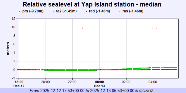 PSMSL Annual Mean Sea Level for '1251' 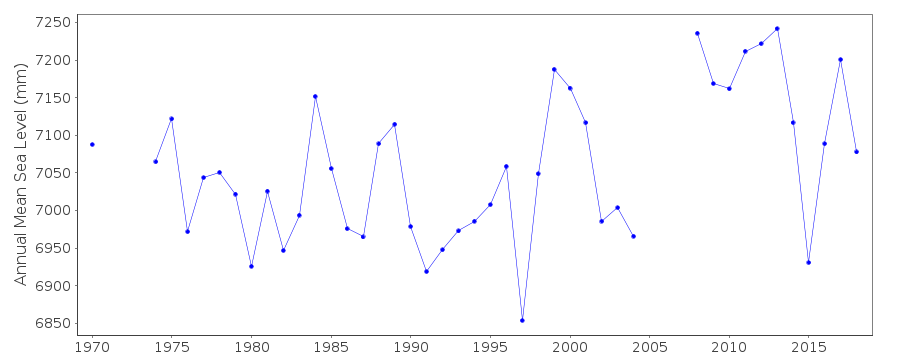 PSMSL Annual Mean Sea Level for '678'  PSMSL Monthly Mean Sea Level for '678' 
|
|
|