 |
SEALEVEL STATION CATALOG (SSC) |
|
|
|
|
|
| Station catalog metadata [edit] | [station overview] |
|---|
| SSC ID | SSC-walt | | Station Name | Walton On The Naze | | Country | United Kingdom | | Latitude | 51.85 | | Longitude | 1.266667 | | DateLastModified | 2015-10-22 19:02:29 |
| Linked codes |
|---|
| Codes | Location | Latitude | Longitude | Sensors | PSMSL: 1224 | WALTON ON THE NAZE | 51.85 | 1.266667 | N/A |
PSMSL: 666 | NORTH WOOLWICH | 51.498194444444444 | 0.04780555555555556 | N/A |
| Distributed metadata source: PSMSL |
| Name | WALTON ON THE NAZE |
| Is RLR | Y |
| Has RLR Diagram | Y link |
| QC Flag | N |
| Old ID | 170/074 |
| Last Updated | 1991-02-20 |
| Supplier | N.O.C. |
| Address | British Oceanographic Data Centre, National Oceanography Centre, Joseph Proudman Building, 6 Brownlow Street, Liverpool, L3 5DA, UNITED KINGDOM |
| Metric Start | 1968 |
| Metric End | 1978 |
| Metric Completeness | 87.1 |
| RLR Start | 1968 |
| RLR End | 1978 |
| RLR Completeness | 87.1 |
| Download metric sea level data. | Use only with extreme caution. |
| Name | NORTH WOOLWICH |
| Is RLR | N |
| Has RLR Diagram | N link |
| QC Flag | N |
| Old ID | 170/086 |
| Last Updated | 2019-02-27 |
| Supplier | N.O.C. |
| Address | British Oceanographic Data Centre, National Oceanography Centre, Joseph Proudman Building, 6 Brownlow Street, Liverpool, L3 5DA, UNITED KINGDOM |
| Metric Start | 1951 |
| Metric End | 1970 |
| Metric Completeness | 66.3 |
| Download metric sea level data. | Use only with extreme caution. |
PSMSL Annual Mean Sea Level for '1224' 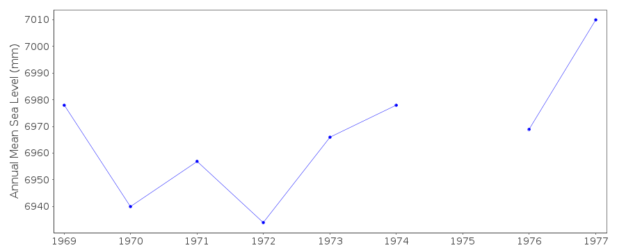 PSMSL Annual Mean Sea Level for '666'  PSMSL Monthly Mean Sea Level for '666' 
|
|
|