 |
SEALEVEL STATION CATALOG (SSC) |
|
|
|
|
|
| Station catalog metadata [edit] | [station overview] |
|---|
| SSC ID | SSC-wake | | Station Name | Wake Island | | Country | United States | | Latitude | 19.29 | | Longitude | 166.618 | | DateLastModified | 2015-10-22 19:02:29 |
| Linked codes |
|---|
| Codes | Location | Latitude | Longitude | Sensors | IOC: wake | Wake_US | 19.29 | 166.618 | wls |
IOC: wake2 | Wake_US | 19.29 | 166.618 | pwl |
GLOSS: 105 | Wake Is., Marshall Is. | 19.28333 | 166.61666 | Float, Pressure, Bubbler, Acoustic |
UHSLC: 51 | Wake | 19.283 | 166.617 | N/A |
PTWC: wake | Wake_US | 19.2907 | 166.6180 | pwc, pwl, bwl |
PTWC: wakx | Wake_US | 19.2907 | 166.6180 | pwc, pwl, bwl |
PSMSL: 595 | WAKE ISLAND | 19.29 | 166.616667 | N/A |
SONEL_TG: 2838 | WAKE ISLAND | 19.29061100 | 166.61771600 | N/A |
| Distributed metadata source: IOC Sea Level Station Monitoring Facility wake |
|---|
| Status | Operational |
| Local Contact | National Ocean Service-NOAA ( USA ) |
| Connection | WEB service |
| Country | USA |
| Sensor 1 | |
| Type of sensor | wls |
| Sampling rate (min) | 1 |
| Distributed metadata source: IOC Sea Level Station Monitoring Facility wake2 |
|---|
| GTS station code | WAKP8 |
| GTS message type | SZPA37 |
| Status | Operational |
| Local Contact | National Ocean Service-NOAA ( USA ) |
| Connection | GTS message |
| Country | USA |
| Sensor 1 | |
| Type of sensor | pwl |
| Sampling rate (min) | 1 |
| Distributed metadata source: GLOSS Station Handbook |
|---|
| Time Zone | 180E, GMT + 12hrs | | Ocean | Pacific | | Operational | Yes | | Additional parameters | Surface temperature, density, barometric pressure | | Tide gauge benchmarks | Benchmark 12(1961) is the primary benchmark stamped 'NO 12 1961' set in the concrete apron at the east front corner of the Federal Aviation Administration Boat House | | Benchmark relationships | TGBM is 14.28ft above Tide Gauge Zero (Station Datum)
NOAA Chart Datum is 3.94ft above Station Datum
Mean Sea Level (1960-1978) is 5.11ft above Station Datum | | Auxiliary benchmarks | 8 additional benchmarks are levelled to the TGBM and to the Tide Stationon a yearly basis (BM P, BM L, BM J, BM 17, BM N, BM 13, BM H, BM K). Site inspection 1993 states 'levels agree with history'. BM Q destroyed in typhoon OMAR. | | Other relevant codes | UHSLC 051 |
| Distributed metadata source: PTWC COMP META file |
| DCP ID | 336AC2C6 |
| WMO | SXXX03 |
| Samp Rate | 6 |
| Num# Samp | 1 |
| Unit | M |
| Scale | 1.3040 |
| Xmt Int. | 006 |
| Fst Min. | 0004 |
| HAR | 1 |
| Owner | NOS |
| Distributed metadata source: UHSLC |
| UHSLC id | 051 |
| SSC id | wake |
| GLOSS id | 105 |
| UHSLC geojson | https://uhslc.soest.hawaii.edu/data/meta.geojson |
| Research quality data version a | 1950-05-31 - 2021-12-31 |
| RQ basin | pacific |
| Fast delivery | 1950-05-31 - 2026-02-28 |
| Distributed metadata source: PSMSL |
| Name | WAKE ISLAND |
| GLOSS id | 105 |
| UHSLC ID | 51 |
| SONEL id | 3706 |
| Is RLR | Y |
| Has RLR Diagram | Y link |
| QC Flag | N |
| Old ID | 720/021 |
| Last Updated | 2026-01-28 |
| Supplier | N.O.A.A. / N.O.S. |
| Address | N.O.A.A. / N.O.S., N/oes33, Ssmc4, Room 6531, 1305 East-West Highway, Silver Spring, , MD 20910, UNITED STATES |
| Metric Start | 1950 |
| Metric End | 2025 |
| Metric Completeness | 93.9 |
| RLR Start | 1950 |
| RLR End | 2025 |
| RLR Completeness | 93.9 |
| Download metric sea level data. | Use only with extreme caution. |
IOC Sea Level Station Monitoring Facility - realtime graph for 'wake' 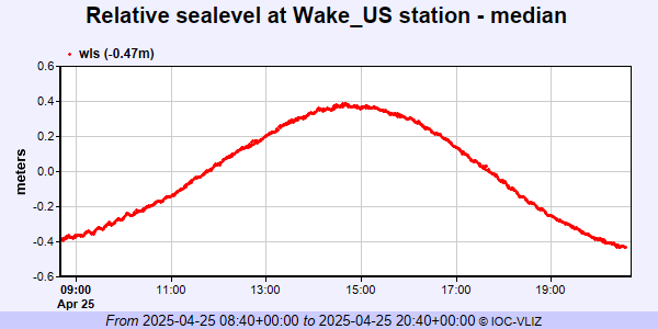 IOC Sea Level Station Monitoring Facility - realtime graph for 'wake2' 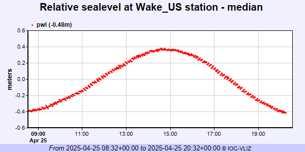 PSMSL Annual Mean Sea Level for '595' 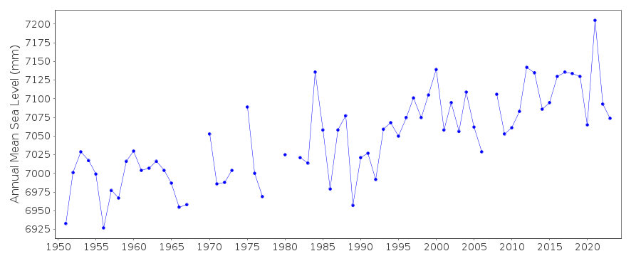 PSMSL Monthly Mean Sea Level for '595' 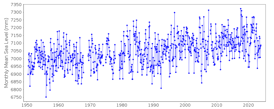
|
|
|