 |
SEALEVEL STATION CATALOG (SSC) |
|
|
|
|
|
| Station catalog metadata [edit] | [station overview] |
|---|
| SSC ID | SSC-wait | | Station Name | Waitangi | | Country | New Zealand | | Latitude | -43.9458 | | Longitude | -176.5608 | | DateLastModified | 2015-10-22 19:02:29 |
| Distributed metadata source: IOC Sea Level Station Monitoring Facility wait |
|---|
| GTS station code | 9321E2EC |
| GTS message type | SEPS40 |
| Status | Down |
| Local Contact | Pacific Tsunami Warning Center ( USA ) |
| Connection | GTS message |
| Country | New Zealand |
| Sensor 1 | |
| Type of sensor | prs |
| Sampling rate (min) | 2 |
| Sensor 2 | |
| Type of sensor | enc |
| Sampling rate (min) | 2 |
| Distributed metadata source: GLOSS Station Handbook |
|---|
| Time Zone | 180E, GMT + 12hr 45m | | Ocean | Pacific | | Operational | Yes | | Responsible country | New Zealand | | Tide gauge benchmarks | Upper of 3 brass pegs set in the sea wall near the root of the Waitangi wharf. | | Benchmark relationships | Tide Gauge Zero (TGZ) = 4.65m below upper of 3 brass pegs
TGZ = 4.08m below middle of 3 brass pegs
TGZ = 3.54m below bottom of 3 brass pegs
| | Auxiliary benchmarks | Aux 1. Middle of 3 brass pegs set in the sea wall near the root of the Waitangi wharf
Aux 2. Bottom of 3 brass pegs set in the sea wall near the root of the Waitangi wharf
| | Other relevant information | A gauge has recently been installed at this site for Tsunami Warning project. At this point in time it is not related to any datum. It is hoped to relate the gauge in the near future to datum. Data are transmitted to the Pacific Tsunami Warning Center in Hawaii. | | Other relevant codes | UHSLC 079 |
| Distributed metadata source: PTWC COMP META file |
| DCP ID | |
| WMO | |
| Samp Rate | |
| Num# Samp | |
| Unit | |
| Scale | |
| Xmt Int. | |
| Fst Min. | |
| HAR | |
| Owner | |
| Distributed metadata source: UHSLC |
| UHSLC id | 079 |
| SSC id | wait |
| GLOSS id | 128 |
| UHSLC geojson | https://uhslc.soest.hawaii.edu/data/meta.geojson |
| Research quality data version a | 2001-01-01 - 2010-09-30 |
| RQ basin | pacific |
| Fast delivery | 2001-01-01 - 2016-02-14 |
| Distributed metadata source: PSMSL |
| Name | CHATHAM ISLAND |
| GLOSS id | 128 |
| UHSLC ID | 79 |
| SONEL id | 1992 |
| Is RLR | Y |
| Has RLR Diagram | Y link |
| QC Flag | N |
| Old ID | 690/401 |
| Last Updated | 2010-11-17 |
| Supplier | UNIVERSITY OF HAWAII SEA LEVEL CENTER |
| Address | University of Hawaii Sea Level Center, Department of Oceanography Division of Natural Sciences, 1000 Pope Road, Honolulu, Hawaii 96822, UNITED STATES |
| Metric Start | 2001 |
| Metric End | 2010 |
| Metric Completeness | 76.7 |
| RLR Start | 2001 |
| RLR End | 2010 |
| RLR Completeness | 76.7 |
| Download metric sea level data. | Use only with extreme caution. |
IOC Sea Level Station Monitoring Facility - realtime graph for 'wait'  PSMSL Annual Mean Sea Level for '1920' 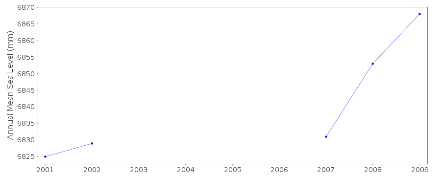 PSMSL Monthly Mean Sea Level for '1920' 
|
|
|