 |
SEALEVEL STATION CATALOG (SSC) |
|
|
|
|
|
| Station catalog metadata [edit] | [station overview] |
|---|
| SSC ID | SSC-vung | | Station Name | Vung Tau | | Country | Vietnam | | Latitude | 10.34 | | Longitude | 107.071 | | DateLastModified | 2015-10-22 19:02:29 |
| Linked codes |
|---|
| Codes | Location | Latitude | Longitude | Sensors | IOC: vung | Vung Tau | 10.34 | 107.071 | prs, rad, ra2, ra3, enc, bat, sw1 |
UHSLC: 383 | Vung Tau | 10.34 | 107.072 | N/A |
PTWC: vtau | Vung_Tau_VN | 10.3402 | 107.0711 | enc, prs, ra2, ra3, rad |
PSMSL: 1495 | VUNGTAU | 10.333333 | 107.066667 | N/A |
| Distributed metadata source: IOC Sea Level Station Monitoring Facility vung |
|---|
| GTS station code | 300434067059990 |
| GTS message type | SZXX01 |
| Status | Operational |
| Local Contact | Hydro-meteorological and Environmental Station Network Center ( Vietnam ) |
| Other Contact | University of Hawaii Sea Level Center ( USA ) |
| Connection | GTS message |
| Country | Viet Nam |
| Sensor 1 | |
| Type of sensor | prs |
| Sampling rate (min) | 1 |
| Sensor 2 | |
| Type of sensor | rad |
| Sampling rate (min) | 1 |
| Sensor 3 | |
| Type of sensor | ra2 |
| Sampling rate (min) | 1 |
| Sensor 4 | |
| Type of sensor | ra3 |
| Sampling rate (min) | 1 |
| Sensor 5 | |
| Type of sensor | enc |
| Sampling rate (min) | 1 |
| Sensor 6 | |
| Type of sensor | bat |
| Sampling rate (min) | 5 |
| Sensor 7 | |
| Type of sensor | sw1 |
| Sampling rate (min) | 5 |
| Distributed metadata source: PTWC COMP META file |
| DCP ID | 300434067059990 |
| WMO | SZXX01 |
| Samp Rate | 1 |
| Num# Samp | 5 |
| Unit | M |
| Scale | 1.0000 |
| Xmt Int. | 005 |
| Fst Min. | 0001 |
| HAR | 1 |
| Owner | UHSLC |
| Distributed metadata source: UHSLC |
| UHSLC id | 383 |
| SSC id | vung |
| UHSLC geojson | https://uhslc.soest.hawaii.edu/data/meta.geojson |
| Research quality data version a | 1986-01-01 - 2002-12-30 |
| Research quality data version b | 2007-10-16 - 2018-12-31 |
| RQ basin | pacific |
| Fast delivery | 2007-10-16 - 2026-02-28 |
| Distributed metadata source: PSMSL |
| Name | VUNGTAU |
| UHSLC ID | 383 |
| Is RLR | Y |
| Has RLR Diagram | Y link |
| QC Flag | N |
| Old ID | 605/021 |
| Last Updated | 2015-11-17 |
| Supplier | MARINE HYDROMETEOROLOGICAL CENTRE |
| Address | Marine Hydrometeorological Centre, Hydro-meteorological and Environmental , Station Network Center, No. 62 Nguyen Chi Thanh Street, Dong Da, Hanoi, VIET NAM |
| Metric Start | 1979 |
| Metric End | 2013 |
| Metric Completeness | 99.0 |
| RLR Start | 1979 |
| RLR End | 2013 |
| RLR Completeness | 99.0 |
| Download metric sea level data. | Use only with extreme caution. |
IOC Sea Level Station Monitoring Facility - realtime graph for 'vung' 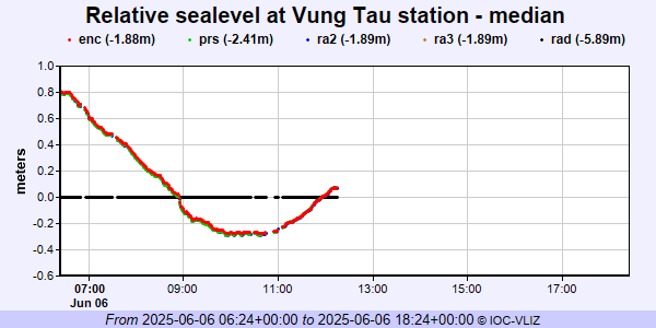 PSMSL Annual Mean Sea Level for '1495' 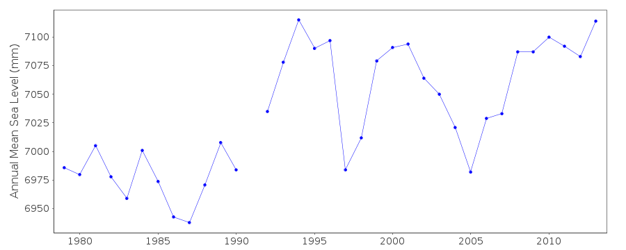 PSMSL Monthly Mean Sea Level for '1495' 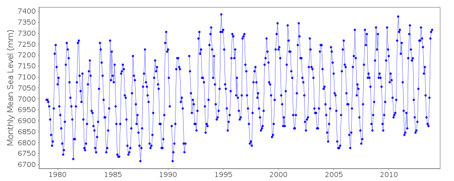
|
|
|