 |
SEALEVEL STATION CATALOG (SSC) |
|
|
|
|
|
| Station catalog metadata [edit] | [station overview] |
|---|
| SSC ID | SSC-vanc | | Station Name | Vancouver | | Country | Canada | | Latitude | 49.283333 | | Longitude | -123.116667 | | DateLastModified | 2015-10-22 19:02:29 |
| Linked codes |
|---|
| Codes | Location | Latitude | Longitude | Sensors | IOC: vhbc | Vancouver Harbor | 49.283333 | -123.116667 | pwl |
PTWC: vhbc | | | | |
PSMSL: 175 | VANCOUVER | 49.283333 | -123.116667 | N/A |
| Distributed metadata source: IOC Sea Level Station Monitoring Facility vhbc |
|---|
| GTS station code | CD400D3A |
| GTS message type | SXAK50 |
| Status | Operational |
| Local Contact | Fisheries and Oceans Canada ( Canada ) |
| Connection | GTS message |
| Country | Canada |
| Sensor 1 | |
| Type of sensor | pwl |
| Sampling rate (min) | 1 |
| Distributed metadata source: PTWC COMP META file |
| DCP ID | |
| WMO | |
| Samp Rate | |
| Num# Samp | |
| Unit | |
| Scale | |
| Xmt Int. | |
| Fst Min. | |
| HAR | |
| Owner | |
| Distributed metadata source: PSMSL |
| Name | VANCOUVER |
| Is RLR | Y |
| Has RLR Diagram | Y link |
| QC Flag | Y |
| Old ID | 822/071 |
| Last Updated | 2025-06-19 |
| Supplier | CANADIAN HYDROGRAPHIC SERVICE |
| Address | Canadian Hydrographic Service, 615 Booth Street, Ottawa , Ontario K1A 0E6, CANADA |
| Metric Start | 1909 |
| Metric End | 2024 |
| Metric Completeness | 83.5 |
| RLR Start | 1909 |
| RLR End | 2024 |
| RLR Completeness | 83.5 |
| Download metric sea level data. | Use only with extreme caution. |
IOC Sea Level Station Monitoring Facility - realtime graph for 'vhbc' 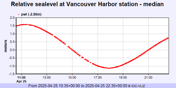 PSMSL Annual Mean Sea Level for '175' 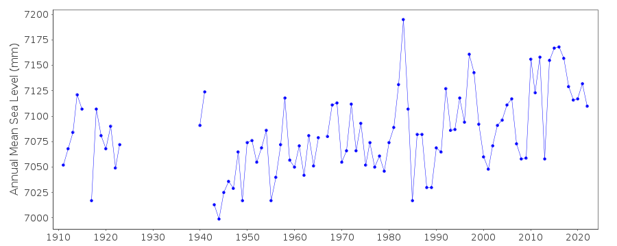 PSMSL Monthly Mean Sea Level for '175' 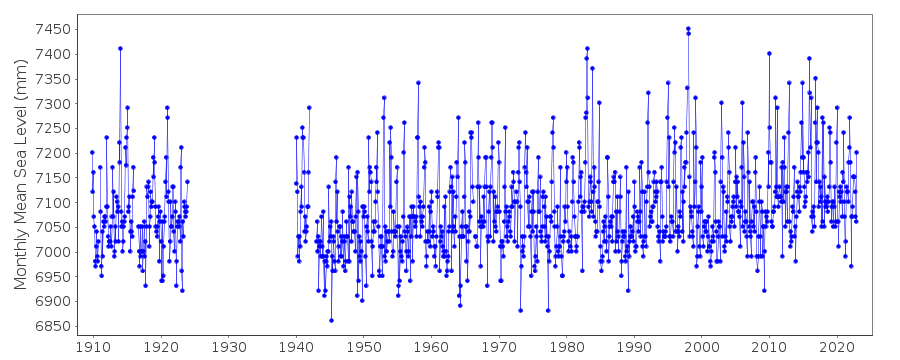
|
|
|