| Station catalog metadata [edit] | [station overview] |
|---|
| SSC ID | SSC-vair |
| Station Name | Vairao |
| Country | France |
| Latitude | -17.805923 |
| Longitude | -149.295298 |
| DateLastModified | 2025-05-08 22:04:01 |
| Linked codes |
|---|
| Codes | Location | Latitude | Longitude | Sensors |
IOC: vair | Vairao (Tahiti Island - French Polynesia) | -17.805923 | -149.295298 | prs, rad, bat |
PTWC: vair | Vairao_FP_FR | -17.8059 | -149.2953 | prs, rad |
PSMSL: 2242 | VAIRAO | -17.8059 | -149.295 | N/A |
SONEL_GPS: 3243 | VAIRAO | -17.80590000 | -149.29500000 | N/A |
SONEL_TG: 3171 | VAIRAO | -17.80590000 | -149.29500000 | N/A |
| Distributed metadata source: IOC Sea Level Station Monitoring Facility vair |
|---|
| GTS station code | FAA022BE |
| GTS message type | SEHI40 |
| Status | Operational |
| Local Contact | University of French Polynesia ( France ) |
| Other Contact | Service hydrographique et océanographique de la marine ( France ) |
| Other Contact | Commissariat à l'Energie Atomique ( France ) |
| Connection | GTS message |
| Country | France |
| Sensor 1 | |
| Type of sensor | prs |
| Sampling rate (min) | 1 |
| Sensor 2 | |
| Type of sensor | rad |
| Sampling rate (min) | 1 |
| Sensor 3 | |
| Type of sensor | bat |
| Sampling rate (min) | 15 |
| Distributed metadata source: PTWC COMP META file |
| DCP ID | FAA022BE |
| WMO | SEHI40 |
| Samp Rate | 1 |
| Num# Samp | 15 |
| Unit | M |
| Scale | 1.0000 |
| Xmt Int. | 015 |
| Fst Min. | 0009 |
| HAR | 1 |
| Owner | SHOM |
| Distributed metadata source: PSMSL |
| Name | VAIRAO |
| SONEL id | 3243 |
| Is RLR | Y |
| Has RLR Diagram | Y link |
| QC Flag | N |
| Old ID | 780/012 |
| Last Updated | 2026-02-20 |
| Supplier | SERVICE HYD. ET OCEAN. DE LA MARINE |
| Address | SHOM, 13 rue de Chatelier, 29200 BREST , FRANCE |
| Metric Start | 1973 |
| Metric End | 2024 |
| Metric Completeness | 22.4 |
| RLR Start | 1973 |
| RLR End | 2024 |
| RLR Completeness | 22.0 |
| Download metric sea level data. | Use only with extreme caution. |
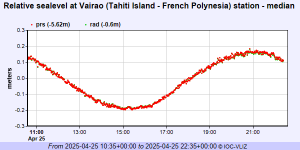
IOC Sea Level Station Monitoring Facility - realtime graph for 'vair'
PSMSL Annual Mean Sea Level for '2242'

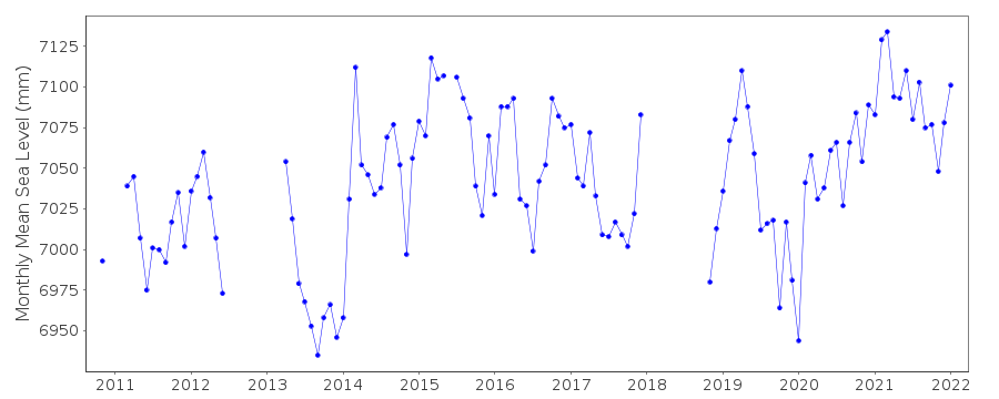
PSMSL Monthly Mean Sea Level for '2242'