 |
SEALEVEL STATION CATALOG (SSC) |
|
|
|
|
|
| Station catalog metadata [edit] | [station overview] |
|---|
| SSC ID | SSC-ushu | | Station Name | Ushuaia | | Country | Argentina | | Latitude | -54.817 | | Longitude | -68.217 | | DateLastModified | 2015-10-22 19:02:29 |
| Distributed metadata source: IOC Sea Level Station Monitoring Facility ushu |
|---|
| GTS station code | 300434064784550 |
| GTS message type | SZXX01 |
| Status | Operational |
| Local Contact | Armada Argentina Servicio de Hidrografía Naval ( Argentina ) |
| Other Contact | University of Hawaii Sea Level Center ( USA ) |
| Connection | GTS message |
| Country | Argentina |
| Sensor 1 | |
| Type of sensor | rad |
| Sampling rate (min) | 1 |
| Sensor 2 | |
| Type of sensor | ra2 |
| Sampling rate (min) | 1 |
| Sensor 3 | |
| Type of sensor | bat |
| Sampling rate (min) | 5 |
| Sensor 4 | |
| Type of sensor | sw1 |
| Sampling rate (min) | 60 |
| Sensor 5 | |
| Type of sensor | sw2 |
| Sampling rate (min) | 60 |
| Distributed metadata source: GLOSS Station Handbook |
|---|
| Time Zone | 045W, GMT - 3hrs | | Ocean | Atlantic | | Operational | Yes | | Responsible country | Argentina | | Additional parameters | wind speed/direction/gust, air & water temp., air pressure | | Tide gauge benchmarks | Benchmark bolt inside tide gauge hut adjacent to stilling well. Acoustic gauge is referred to the same benchmarks as the float gauge. Aquatrack levelling point is 10.000m above an arbitrary 'zero'. | | Benchmark relationships | Tide gauge zero (TGZ) = local chart datum
TGZ = 5.52m below TGBM (from 1951 onwards)
NOAA Gage 0 is designated as 2.0000m below chart zero. Chart zero refers to MLLW, indicated on the Plano de Reduccion de la Carta Argentina.
| | Auxiliary benchmarks | AUX 1: Punto fijo ubicado frente la Base Naval Ushuaia, en las adyacencias de la Comandancia
Other benchmarks include: 1000 A 1991, 1000 B 1991, Unstamped 1, Unstamped 2, II, MOJON X1 1978.
| | Other relevant information | Gauge was moved 900m in May 1970. PSMSL hold data collected prior to move (PSMSL Code 860/001, 1957-1969). | | Other relevant codes | UHSLC 600 |
| Distributed metadata source: PTWC COMP META file |
| DCP ID | 300434064784550 |
| WMO | SZXX01 |
| Samp Rate | 1 |
| Num# Samp | 5 |
| Unit | M |
| Scale | 1.0000 |
| Xmt Int. | 005 |
| Fst Min. | 0001 |
| HAR | 1 |
| Owner | SHN |
| Distributed metadata source: UHSLC |
| UHSLC id | 600 |
| SSC id | ushu2 |
| GLOSS id | 181 |
| UHSLC geojson | https://uhslc.soest.hawaii.edu/data/meta.geojson |
| Research quality data version a | 1996-01-01 - 2024-12-31 |
| RQ basin | atlantic |
| Fast delivery | 1996-01-01 - 2026-04-23 |
| Distributed metadata source: PSMSL |
| Name | USHUAIA II |
| GLOSS id | 181 |
| UHSLC ID | 600 |
| SONEL id | 2506 |
| Is RLR | Y |
| Has RLR Diagram | Y link |
| QC Flag | Y |
| Old ID | 860/002 |
| Last Updated | 2007-11-12 |
| Supplier | SERVICIO DE HIDROGRAFIA NAVAL, ARGENTINA |
| Address | Servicio de Hidrografia Naval, Departmento Oceanografia, Av. Montes de Oca 2124, 1271 Buenos Aires, ARGENTINA |
| Metric Start | 1970 |
| Metric End | 2006 |
| Metric Completeness | 80.9 |
| RLR Start | 1970 |
| RLR End | 2006 |
| RLR Completeness | 80.9 |
| Download metric sea level data. | Use only with extreme caution. |
| Name | USHUAIA III |
| GLOSS id | 181 |
| UHSLC ID | 600 |
| Is RLR | Y |
| Has RLR Diagram | Y link |
| QC Flag | N |
| Old ID | 860/003 |
| Last Updated | 2023-03-02 |
| Supplier | UNIVERSITY OF HAWAII SEA LEVEL CENTER |
| Address | University of Hawaii Sea Level Center, Department of Oceanography Division of Natural Sciences, 1000 Pope Road, Honolulu, Hawaii 96822, UNITED STATES |
| Metric Start | 1993 |
| Metric End | 2018 |
| Metric Completeness | 67.9 |
| RLR Start | 1993 |
| RLR End | 2018 |
| RLR Completeness | 67.9 |
| Download metric sea level data. | Use only with extreme caution. |
| Name | USHUAIA I |
| GLOSS id | 181 |
| UHSLC ID | 600 |
| SONEL id | 2506 |
| Is RLR | Y |
| Has RLR Diagram | Y link |
| QC Flag | N |
| Old ID | 860/001 |
| Last Updated | 2024-01-04 |
| Supplier | SERVICIO DE HIDROGRAFIA NAVAL, ARGENTINA |
| Address | Servicio de Hidrografia Naval, Departmento Oceanografia, Av. Montes de Oca 2124, 1271 Buenos Aires, ARGENTINA |
| Metric Start | 1957 |
| Metric End | 2022 |
| Metric Completeness | 23.0 |
| RLR Start | 1957 |
| RLR End | 2022 |
| RLR Completeness | 23.0 |
| Download metric sea level data. | Use only with extreme caution. |
IOC Sea Level Station Monitoring Facility - realtime graph for 'ushu' 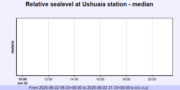 PSMSL Annual Mean Sea Level for '1271'  PSMSL Annual Mean Sea Level for '1850' 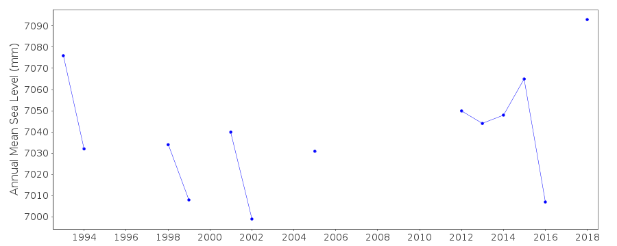 PSMSL Annual Mean Sea Level for '874' 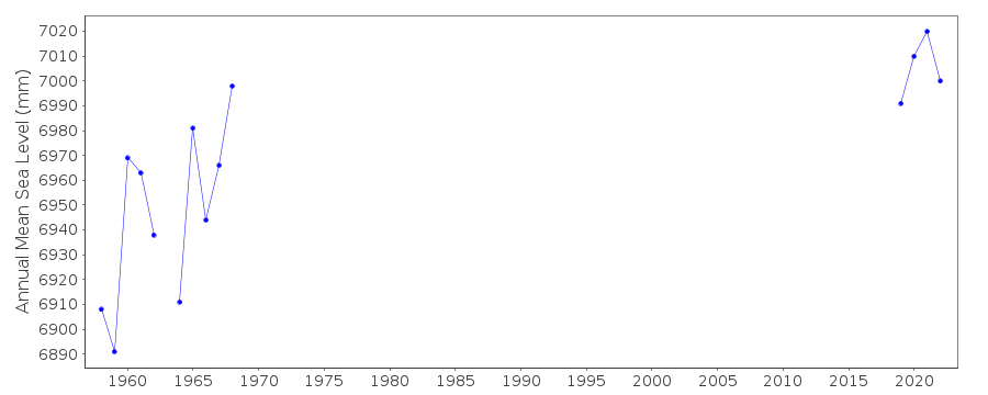 PSMSL Monthly Mean Sea Level for '874' 
|
|
|