 |
SEALEVEL STATION CATALOG (SSC) |
|
|
|
|
|
| Station catalog metadata [edit] | [station overview] |
|---|
| SSC ID | SSC-thev | | Station Name | Thevenard | | Country | Australia | | Latitude | -32.1489 | | Longitude | 133.6413 | | DateLastModified | 2015-10-22 19:02:29 |
| Distributed metadata source: IOC Sea Level Station Monitoring Facility thev |
|---|
| GTS station code | 62000 |
| GTS message type | SZAU01 |
| Status | Operational |
| Local Contact | National Tidal Centre/Australian Bureau of Meteorology ( Australia ) |
| Connection | GTS message |
| Country | Australia |
| Sensor 1 | |
| Type of sensor | prs |
| Sampling rate (min) | 1 |
| Distributed metadata source: GLOSS Station Handbook |
|---|
| Ocean | Southern | | Operational | Yes | | Responsible country | Australia | | Data acquisition rate | 6 minute interval | | Additional parameters | barometric pressure, water/air temperature, wind speed and direction | | Tide gauge benchmarks | BM 1476 = Coastal array primary deep Bench Mark near Harbour Master's Office 3D 4.478m above Australian Height Datum (AHD) | | Benchmark relationships | Chart Datum = 0.993m below Australian Height Datum (AHD) | | Auxiliary benchmarks | Tie bolt BM
BM 1476
NMV/E/64
NMV/E/18
NMV/E/19
5633/1591 3D SEAFRAME Sensor BM = 4.497m AHD
BM 1477 3D Coastal Array BM = 4.644m AHD
BM 1153 3D Datum for AHD Heights = 2.935m AHD
| | Other relevant information | PSMSL also hold data from another gauge at Thevenard (PSMSL Code 680/440 1966-1990). | | Other relevant codes | NTF port no. 62000 |
| Distributed metadata source: PTWC COMP META file |
| DCP ID | 62000 |
| WMO | SZAU01 |
| Samp Rate | 1 |
| Num# Samp | 6 |
| Unit | M |
| Scale | 1.0000 |
| Xmt Int. | 003 |
| Fst Min. | 0000 |
| HAR | 1 |
| Owner | ABM |
| Distributed metadata source: UHSLC |
| UHSLC id | 128 |
| SSC id | thev |
| GLOSS id | 308 |
| UHSLC geojson | https://uhslc.soest.hawaii.edu/data/meta.geojson |
| Research quality data version a | 1992-03-19 - 2021-12-31 |
| RQ basin | indian |
| Fast delivery | 1992-03-19 - 2026-05-31 |
| Distributed metadata source: PSMSL |
| Name | THEVENARD II |
| GLOSS id | 308 |
| UHSLC ID | 128 |
| Is RLR | N |
| Has RLR Diagram | N link |
| QC Flag | N |
| Old ID | 680/440 |
| Last Updated | 1993-05-24 |
| Supplier | NATIONAL TIDAL FACILITY |
| Address | National Tidal Facility, G.P.O. Box 2100, S.A. 5001, Adelaide , AUSTRALIA |
| Metric Start | 1966 |
| Metric End | 1990 |
| Metric Completeness | 97.7 |
| Download metric sea level data. | Use only with extreme caution. |
| Name | THEVENARD |
| GLOSS id | 308 |
| UHSLC ID | 128 |
| SONEL id | 3624 |
| Is RLR | Y |
| Has RLR Diagram | Y link |
| QC Flag | N |
| Old ID | 680/441 |
| Last Updated | 2025-03-20 |
| Supplier | NATIONAL TIDAL CENTRE |
| Address | National Tidal Centre, Bureau of Meteorology, PO Box 421, Kent Town 5071, South Australia, AUSTRALIA |
| Metric Start | 1934 |
| Metric End | 2025 |
| Metric Completeness | 70.4 |
| RLR Start | 1993 |
| RLR End | 2025 |
| RLR Completeness | 92.4 |
| Download metric sea level data. | Use only with extreme caution. |
IOC Sea Level Station Monitoring Facility - realtime graph for 'thev' 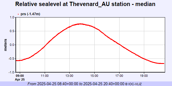 PSMSL Annual Mean Sea Level for '1169'  PSMSL Annual Mean Sea Level for '386' 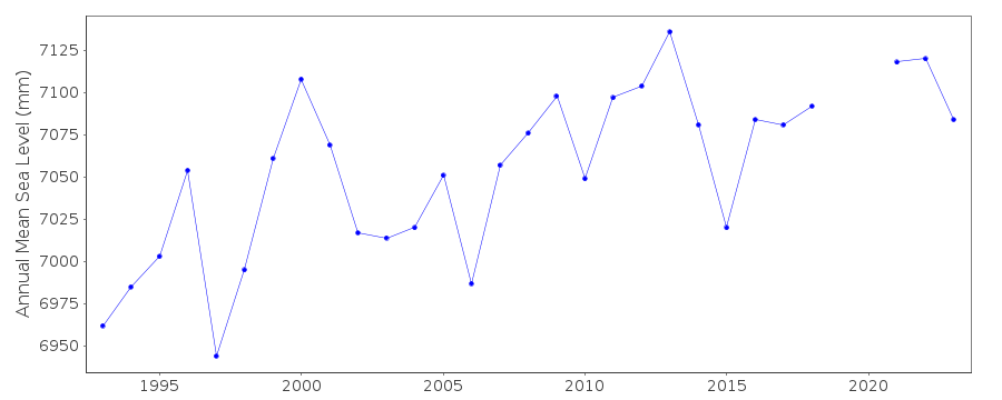 PSMSL Monthly Mean Sea Level for '386' 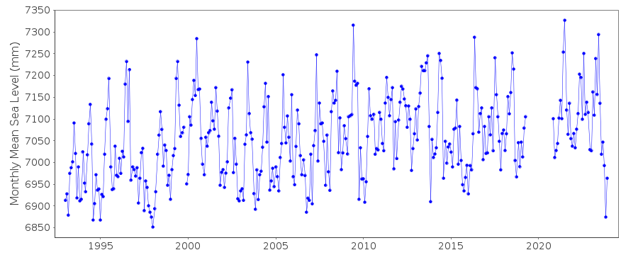
|
|
|