 |
SEALEVEL STATION CATALOG (SSC) |
|
|
|
|
|
| Station catalog metadata [edit] | [station overview] |
|---|
| SSC ID | SSC-tanjo | | Station Name | Tanjong Pagar | | Country | Singapore | | Latitude | 1.2616 | | Longitude | 103.8516 | | DateLastModified | 2015-10-22 19:02:29 |
| Distributed metadata source: IOC Sea Level Station Monitoring Facility tanjo |
|---|
| GTS station code | 00044 |
| GTS message type | SZSR01 |
| Status | Down |
| Local Contact | Maritime and Port Authority of Singapore - The Hydrographic Office ( Singapore ) |
| Other Contact | National Tidal Centre/Australian Bureau of Meteorology ( Australia ) |
| Connection | GTS message |
| Country | Singapore |
| Sensor 1 | |
| Type of sensor | prs |
| Sampling rate (min) | 6 |
| Distributed metadata source: GLOSS Station Handbook |
|---|
| Time Zone | 120E, GMT + 8hrs | | Ocean | Indian | | Operational | Yes | | Responsible country | Singapore | | Benchmark relationships | Tide Gauge Zero = 1.637m below Precise Levelling Datum (PLD) (from 1982 onwards) | | Other relevant codes | UHSLC 327 |
| Distributed metadata source: PTWC COMP META file |
| DCP ID | |
| WMO | |
| Samp Rate | |
| Num# Samp | |
| Unit | |
| Scale | |
| Xmt Int. | |
| Fst Min. | |
| HAR | |
| Owner | |
| Distributed metadata source: UHSLC |
| UHSLC id | 327 |
| SSC id | kepp |
| GLOSS id | 44 |
| UHSLC geojson | https://uhslc.soest.hawaii.edu/data/meta.geojson |
| Research quality data version a | 1981-08-13 - 1990-01-31 |
| RQ basin | pacific |
| UHSLC id | 337 |
| SSC id | vict |
| GLOSS id | 44 |
| UHSLC geojson | https://uhslc.soest.hawaii.edu/data/meta.geojson |
| Research quality data version a | 1972-01-01 - 1981-12-31 |
| RQ basin | pacific |
| UHSLC id | 699 |
| SSC id | tanjo |
| GLOSS id | 44 |
| UHSLC geojson | https://uhslc.soest.hawaii.edu/data/meta.geojson |
| Research quality data version a | 1984-01-01 - 2023-12-31 |
| RQ basin | pacific |
| Fast delivery | 1984-01-01 - 2023-12-31 |
| Distributed metadata source: PSMSL |
| Name | VICTORIA DOCK |
| GLOSS id | 44 |
| UHSLC ID | 327 |
| Is RLR | Y |
| Has RLR Diagram | Y link |
| QC Flag | N |
| Old ID | 555/001 |
| Last Updated | 1988-05-26 |
| Supplier | MARITIME PORT AUTHORITY OF SINGAPORE |
| Address | Maritime Port Authority of Singapore, Hydrographic Department, 460 Alexandra Road, PSA Building, #20-00 Singapore 119963, SINGAPORE |
| Metric Start | 1966 |
| Metric End | 1981 |
| Metric Completeness | 91.7 |
| RLR Start | 1966 |
| RLR End | 1981 |
| RLR Completeness | 91.7 |
| Download metric sea level data. | Use only with extreme caution. |
| Name | KEPPEL HARBOUR |
| GLOSS id | 44 |
| UHSLC ID | 327 |
| Is RLR | Y |
| Has RLR Diagram | Y link |
| QC Flag | N |
| Old ID | 555/003 |
| Last Updated | 1992-06-09 |
| Supplier | MARITIME PORT AUTHORITY OF SINGAPORE |
| Address | Maritime Port Authority of Singapore, Hydrographic Department, 460 Alexandra Road, PSA Building, #20-00 Singapore 119963, SINGAPORE |
| Metric Start | 1981 |
| Metric End | 1989 |
| Metric Completeness | 92.6 |
| RLR Start | 1981 |
| RLR End | 1989 |
| RLR Completeness | 92.6 |
| Download metric sea level data. | Use only with extreme caution. |
| Name | TANJONG PAGAR |
| GLOSS id | 44 |
| UHSLC ID | 327 |
| Is RLR | Y |
| Has RLR Diagram | Y link |
| QC Flag | N |
| Old ID | 555/002 |
| Last Updated | 2025-05-07 |
| Supplier | MARITIME PORT AUTHORITY OF SINGAPORE |
| Address | Maritime Port Authority of Singapore, Hydrographic Department, 460 Alexandra Road, PSA Building, #20-00 Singapore 119963, SINGAPORE |
| Metric Start | 1989 |
| Metric End | 2024 |
| Metric Completeness | 98.6 |
| RLR Start | 1989 |
| RLR End | 2024 |
| RLR Completeness | 98.6 |
| Download metric sea level data. | Use only with extreme caution. |
| Name | JOHOR BAHRU |
| UHSLC ID | 321 |
| Is RLR | Y |
| Has RLR Diagram | Y link |
| QC Flag | N |
| Old ID | 550/011 |
| Last Updated | 2017-05-04 |
| Supplier | DEPARTMENT OF SURVEY AND MAPPING |
| Address | Department of Survey and Mapping, Wisma JUPEM, Jalan Semarak, 50578 Kuala Lumpur, MALAYSIA |
| Metric Start | 1923 |
| Metric End | 2014 |
| Metric Completeness | 32.9 |
| RLR Start | 1984 |
| RLR End | 2014 |
| RLR Completeness | 91.1 |
| Download metric sea level data. | Use only with extreme caution. |
| Name | SEMBAWANG |
| UHSLC ID | 321 |
| Is RLR | Y |
| Has RLR Diagram | Y link |
| QC Flag | N |
| Old ID | 555/051 |
| Last Updated | 2023-04-24 |
| Supplier | MARITIME PORT AUTHORITY OF SINGAPORE |
| Address | Maritime Port Authority of Singapore, Hydrographic Department, 460 Alexandra Road, PSA Building, #20-00 Singapore 119963, SINGAPORE |
| Metric Start | 1954 |
| Metric End | 2022 |
| Metric Completeness | 83.0 |
| RLR Start | 1954 |
| RLR End | 2022 |
| RLR Completeness | 83.0 |
| Download metric sea level data. | Use only with extreme caution. |
IOC Sea Level Station Monitoring Facility - realtime graph for 'tanjo'  PSMSL Annual Mean Sea Level for '1183' 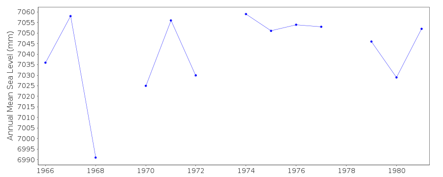 PSMSL Annual Mean Sea Level for '1534'  PSMSL Annual Mean Sea Level for '1746' 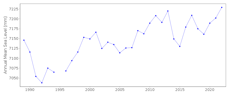 PSMSL Annual Mean Sea Level for '248'  PSMSL Annual Mean Sea Level for '724' 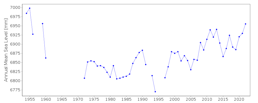 PSMSL Monthly Mean Sea Level for '724' 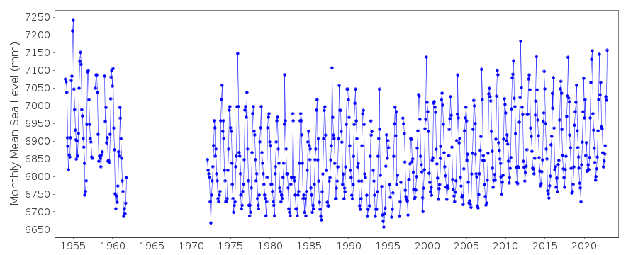
|
|
|