 |
SEALEVEL STATION CATALOG (SSC) |
|
|
|
|
|
| Station catalog metadata [edit] | [station overview] |
|---|
| SSC ID | SSC-tangi | | Station Name | Tangachchimadam | | Country | India | | Latitude | 9.283333 | | Longitude | 79.25 | | DateLastModified | 2015-10-22 19:02:29 |
| Linked codes |
|---|
| Codes | Location | Latitude | Longitude | Sensors | PSMSL: 1258 | TANGACHCHIMADAM | 9.283333 | 79.25 | N/A |
| Distributed metadata source: PSMSL |
| Name | TANGACHCHIMADAM |
| Is RLR | Y |
| Has RLR Diagram | Y link |
| QC Flag | N |
| Old ID | 500/085 |
| Last Updated | 1990-03-21 |
| Supplier | SURVEY OF INDIA |
| Address | Survey of India, Geodetic and Research Branch, 17 E.C. Road, Dehra Dun , PIN 248 001, INDIA |
| Metric Start | 1969 |
| Metric End | 1983 |
| Metric Completeness | 81.7 |
| RLR Start | 1969 |
| RLR End | 1983 |
| RLR Completeness | 81.7 |
| Download metric sea level data. | Use only with extreme caution. |
PSMSL Annual Mean Sea Level for '1258' 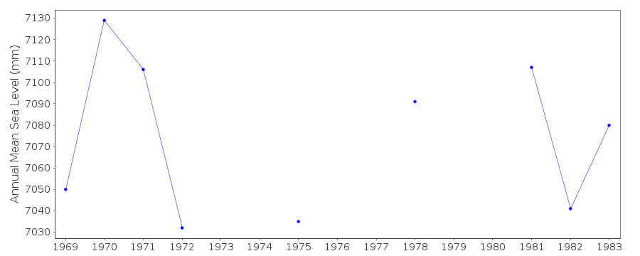 PSMSL Monthly Mean Sea Level for '1258' 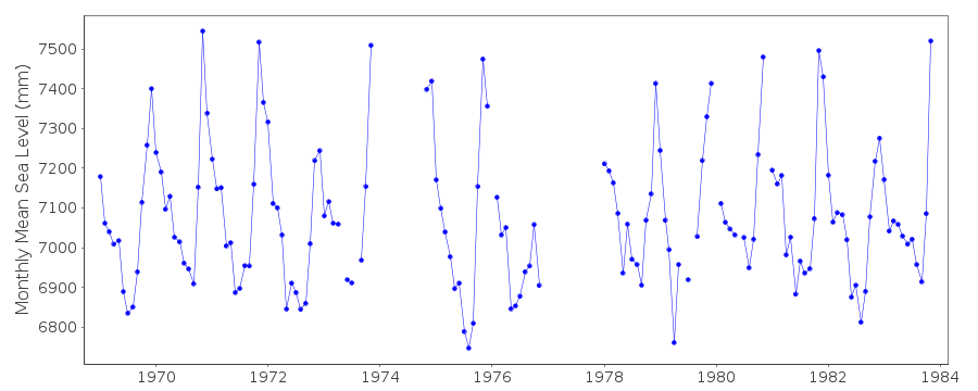
|
|
|