 |
SEALEVEL STATION CATALOG (SSC) |
|
|
|
|
|
| Station catalog metadata [edit] | [station overview] |
|---|
| SSC ID | SSC-stpt | | Station Name | Settlement Point | | Country | Bahamas | | Latitude | 26.6833324 | | Longitude | -78.98333 | | DateLastModified | 2016-10-07 08:54:29 |
| Linked codes |
|---|
| Codes | Location | Latitude | Longitude | Sensors | IOC: setp1 | Settlement pt | 26.6833324 | -78.98333 | prs, rad, ra2, ra3, bat, atm, sw1, sw2 |
GLOSS: 211 | Settlement Point | 26.71666 | -78.98333 | Float, Bubbler, Acoustic |
UHSLC: 257 | Settlement Point | 26.6899 | -78.96698 | N/A |
PTWC: stpt | Settlement_PT_BS | 26.6833 | -78.9833 | prs, ra2, ra3, rad |
PSMSL: 1646 | SETTLEMENT POINT | 26.71 | -78.996667 | N/A |
PSMSL: 1928 | SETTLEMENT POINT A | 26.683333 | -78.983333 | N/A |
SONEL_GPS: 2981 | FREEPORT | 26.68990000 | -78.96700000 | N/A |
SONEL_GPS: 674 | FREEPORT | 26.70249939 | -78.99259949 | N/A |
SONEL_TG: 2155 | FREEPORT | 26.71700000 | -78.98300000 | N/A |
| Distributed metadata source: IOC Sea Level Station Monitoring Facility setp1 |
|---|
| GTS station code | 300434068599910 |
| GTS message type | SZXX01 |
| Status | Operational |
| Local Contact | Bahamas Department of Meteorology ( Bahamas ) |
| Other Contact | University of Hawaii Sea Level Center ( USA ) |
| Other Contact | International Tsunami Information Center Caribbean Office ( USA ) |
| Connection | GTS message |
| Country | Bahamas/Bahama Islands |
| Sensor 1 | |
| Type of sensor | prs |
| Sampling rate (min) | 1 |
| Sensor 2 | |
| Type of sensor | rad |
| Sampling rate (min) | 1 |
| Sensor 3 | |
| Type of sensor | ra2 |
| Sampling rate (min) | 1 |
| Sensor 4 | |
| Type of sensor | ra3 |
| Sampling rate (min) | 1 |
| Sensor 5 | |
| Type of sensor | bat |
| Sampling rate (min) | 5 |
| Sensor 6 | |
| Type of sensor | atm |
| Sampling rate (min) | 5 |
| Sensor 7 | |
| Type of sensor | sw1 |
| Sampling rate (min) | 60 |
| Sensor 8 | |
| Type of sensor | sw2 |
| Sampling rate (min) | 60 |
| Distributed metadata source: GLOSS Station Handbook |
|---|
| Time Zone | 075W, GMT - 5hrs | | Ocean | Atlantic | | Operational | Yes | | Additional parameters | Wind, air temp., sea surface temp., barometric pressure | | Tide gauge benchmarks | 5 local benchmarks used to determine site stability | | Benchmark relationships | Local levelling with respect to station datum.
Station datum is the zero of the original staff established on 18 October 1985.
| | Other relevant information | Two tide gauges here, A and B. Both have GPS | | Other relevant codes | UHSLC 257 |
| Distributed metadata source: PTWC COMP META file |
| DCP ID | 300434068599910 |
| WMO | SZXX01 |
| Samp Rate | 1 |
| Num# Samp | 5 |
| Unit | M |
| Scale | 1.0000 |
| Xmt Int. | 005 |
| Fst Min. | 0001 |
| HAR | 1 |
| Owner | UHSLC |
| Distributed metadata source: UHSLC |
| UHSLC id | 257 |
| SSC id | setp1 |
| GLOSS id | 211 |
| UHSLC geojson | https://uhslc.soest.hawaii.edu/data/meta.geojson |
| Research quality data version a | 1985-10-19 - 2002-05-31 |
| Research quality data version b | 2002-06-04 - 2018-12-31 |
| RQ basin | atlantic |
| Fast delivery | 2002-06-04 - 2026-05-31 |
| Distributed metadata source: PSMSL |
| Name | SETTLEMENT POINT |
| GLOSS id | 211 |
| UHSLC ID | 257 |
| SONEL id | 2981 |
| Is RLR | Y |
| Has RLR Diagram | Y link |
| QC Flag | N |
| Old ID | 941/001 |
| Last Updated | 2002-07-10 |
| Supplier | N.O.A.A. / N.O.S. |
| Address | N.O.A.A. / N.O.S., N/oes33, Ssmc4, Room 6531, 1305 East-West Highway, Silver Spring, , MD 20910, UNITED STATES |
| Metric Start | 1985 |
| Metric End | 2001 |
| Metric Completeness | 83.3 |
| RLR Start | 1985 |
| RLR End | 2001 |
| RLR Completeness | 83.3 |
| Download metric sea level data. | Use only with extreme caution. |
| Name | SETTLEMENT POINT A |
| GLOSS id | 211 |
| UHSLC ID | 257 |
| SONEL id | 2981 |
| Is RLR | Y |
| Has RLR Diagram | Y link |
| QC Flag | N |
| Old ID | 941/002 |
| Last Updated | 2020-01-29 |
| Supplier | UNIVERSITY OF HAWAII SEA LEVEL CENTER |
| Address | University of Hawaii Sea Level Center, Department of Oceanography Division of Natural Sciences, 1000 Pope Road, Honolulu, Hawaii 96822, UNITED STATES |
| Metric Start | 2002 |
| Metric End | 2018 |
| Metric Completeness | 89.7 |
| RLR Start | 2002 |
| RLR End | 2018 |
| RLR Completeness | 89.7 |
| Download metric sea level data. | Use only with extreme caution. |
IOC Sea Level Station Monitoring Facility - realtime graph for 'setp1' 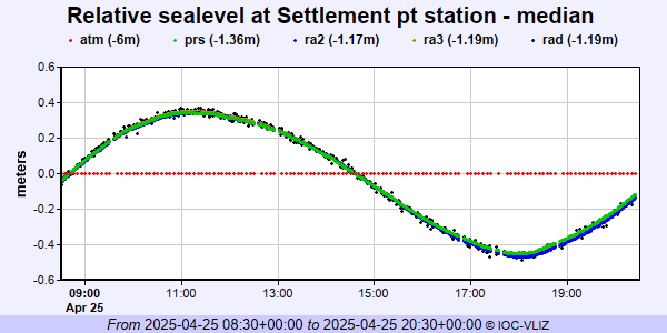 PSMSL Annual Mean Sea Level for '1646' 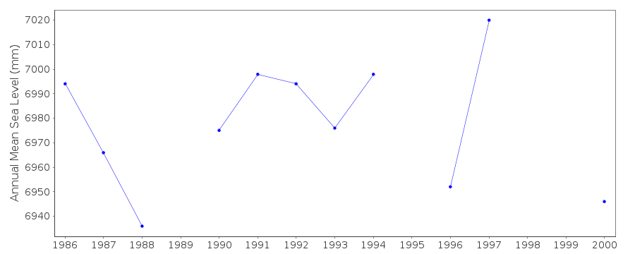 PSMSL Annual Mean Sea Level for '1928'  PSMSL Monthly Mean Sea Level for '1928' 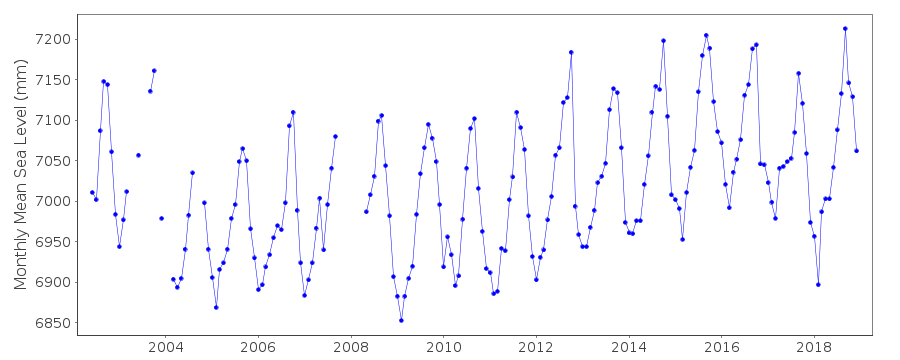
|
|
|