 |
SEALEVEL STATION CATALOG (SSC) |
|
|
|
|
|
| Station catalog metadata [edit] | [station overview] |
|---|
| SSC ID | SSC-stor | | Station Name | Stornoway | | Country | United Kingdom | | Latitude | 58.2 | | Longitude | -6.38 | | DateLastModified | 2015-10-22 19:02:29 |
| Distributed metadata source: IOC Sea Level Station Monitoring Facility stor |
|---|
| Status | Operational |
| Local Contact | National Oceanography Centre ( UK ) |
| Connection | FTP box |
| Country | UK |
| Sensor 1 | |
| Type of sensor | bub |
| Sampling rate (min) | 15 |
| Distributed metadata source: IOC Sea Level Station Monitoring Facility stor2 |
|---|
| Status | Down |
| Local Contact | National Oceanography Centre ( UK ) |
| Connection | SOCKET |
| Country | UK |
| Sensor 1 | |
| Type of sensor | bub |
| Sampling rate (min) | 0.1667 |
| Sensor 2 | |
| Type of sensor | bub1 |
| Sampling rate (min) | 0.1667 |
| Distributed metadata source: GLOSS Station Handbook |
|---|
| Time Zone | 000E, GMT | | Ocean | Atlantic | | Operational | Yes | | Additional parameters | Mid-tide datum | | Tide gauge benchmarks | Ordnance Survey Benchmark bolt E side of No. 2 Wharf (Bank Street Wharf) Ordnance Survey grid reference NB 4228 3264 | | Benchmark relationships | Tide gauge zero (TGZ) = Admiralty Chart Datum (ACD)
TGZ = 2.71m below Local Ordnance Datum
TGZ = 6.368m below TGBM (from 1988 onwards)
| | Auxiliary benchmarks | AUX 1: Ordnance Survey Benchmark bolt in steps NE angle of King Edward Wharf. Ordnance Survey grid reference NB 4215 3271.
AUX 2: Amity House, E side of Esplanade Road, N face, NW angle. Ordnance Survey grid reference NB 4212 3275.
AUX 3: Bank S side of Worth Beach, NW angle, N face. Ordnance Survey grid reference NB 4223 3280.
| | Other relevant codes | UHSLC 295 | | Nearest Met. station | Stornoway airport |
| Distributed metadata source: UHSLC |
| UHSLC id | 295 |
| SSC id | stor |
| GLOSS id | 238 |
| UHSLC geojson | https://uhslc.soest.hawaii.edu/data/meta.geojson |
| Research quality data version a | 1976-01-01 - 2016-12-31 |
| RQ basin | atlantic |
| Fast delivery | 1976-01-01 - 2016-12-31 |
| Distributed metadata source: PSMSL |
| Name | STORNOWAY |
| GLOSS id | 238 |
| UHSLC ID | 295 |
| SONEL id | 1908 |
| Is RLR | Y |
| Has RLR Diagram | Y link |
| QC Flag | N |
| Old ID | 170/251 |
| Last Updated | 2026-02-19 |
| Supplier | ENVIRONMENT AGENCY |
| Address | Environment Agency, Horizon House, Deanery Road, BS1 5AH, Bristol, UNITED KINGDOM |
| Metric Start | 1928 |
| Metric End | 2025 |
| Metric Completeness | 59.6 |
| RLR Start | 1977 |
| RLR End | 2025 |
| RLR Completeness | 85.0 |
| Download metric sea level data. | Use only with extreme caution. |
IOC Sea Level Station Monitoring Facility - realtime graph for 'stor'  IOC Sea Level Station Monitoring Facility - realtime graph for 'stor2'  PSMSL Annual Mean Sea Level for '314' 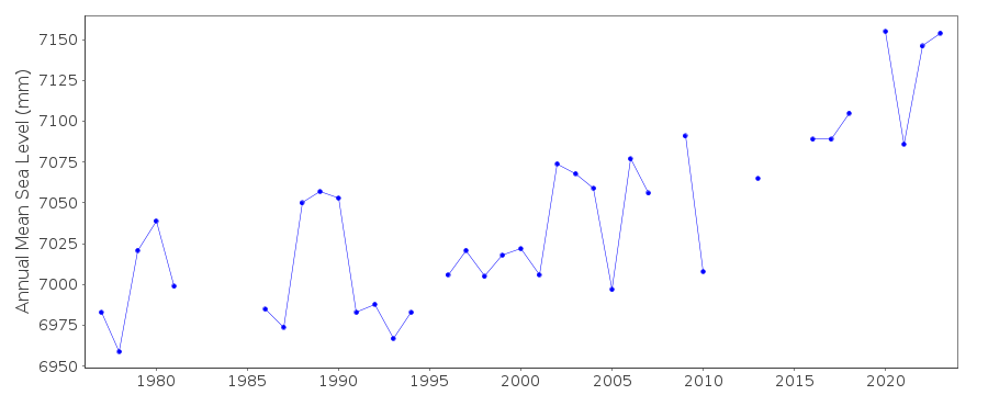 PSMSL Monthly Mean Sea Level for '314' 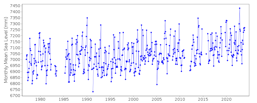
|
|
|