 |
SEALEVEL STATION CATALOG (SSC) |
|
|
|
|
|
| Station catalog metadata [edit] | [station overview] |
|---|
| SSC ID | SSC-sthl | | Station Name | Saint Helena | | Country | Saint Helena | | Latitude | -15.916667 | | Longitude | -5.716667 | | DateLastModified | 2015-10-22 19:02:29 |
| Linked codes |
|---|
| Codes | Location | Latitude | Longitude | Sensors | IOC: sthl | Saint Helena_UK | -15.916667 | -5.716667 | rad, pr1, pr2, bat |
IOC: sthl2 | Saint Helena_UK Ruperts Bay | -15.917918 | -5.714394 | rad, ra2, bat, atm |
GLOSS: 264 | St. Helena | -15.96666 | -5.7 | Pressure |
UHSLC: 292 | St. Helena | -15.9167 | -5.7167 | N/A |
PTWC: sthl | | | | |
PSMSL: 1845 | JAMESTOWN LANDING STEPS | -15.920864 | -5.717961 | N/A |
SONEL_GPS: 2576 | SAINTE-HELENE | -15.94254722 | -5.66733888 | N/A |
SONEL_TG: 1986 | SAINTE-HELENE | -15.92086400 | -5.71796100 | N/A |
| Distributed metadata source: IOC Sea Level Station Monitoring Facility sthl |
|---|
| GTS station code | 26F364EA |
| GTS message type | SXXX32 |
| Status | Down |
| Local Contact | National Oceanography Centre ( UK ) |
| Connection | GTS message |
| Country | Saint-Helena, isles of |
| Sensor 1 | |
| Type of sensor | rad |
| Sampling rate (min) | 1 |
| Sensor 2 | |
| Type of sensor | bat |
| Sampling rate (min) | 15 |
| Sensor 3 | |
| Type of sensor | pr1 |
| Sampling rate (min) | 1 |
| Sensor 4 | |
| Type of sensor | pr2 |
| Sampling rate (min) | 1 |
| Distributed metadata source: IOC Sea Level Station Monitoring Facility sthl2 |
|---|
| GTS station code | 18BC4718 |
| GTS message type | SXXX32 |
| Status | Operational |
| Local Contact | National Oceanography Centre ( UK ) |
| Connection | GTS message |
| Country | Saint-Helena, isles of |
| Sensor 1 | |
| Type of sensor | rad |
| Sampling rate (min) | 1 |
| Sensor 2 | |
| Type of sensor | ra2 |
| Sampling rate (min) | 1 |
| Sensor 3 | |
| Type of sensor | bat |
| Sampling rate (min) | 15 |
| Sensor 4 | |
| Type of sensor | atm |
| Sampling rate (min) | 15 |
| Distributed metadata source: GLOSS Station Handbook |
|---|
| Time Zone | 000E, GMT | | Ocean | Atlantic | | Operational | Yes | | Additional parameters | Atmospheric pressure, sea temperature | | Tide gauge benchmarks | None | | Auxiliary benchmarks | Historic benchmarks only, last levelled in 1986. | | Other relevant information | One year of data from Jamestown, St. Helena (15 55S, 005 42W), 1986-1987. DORIS station on island providing meteorological data for IGN, Paris, France. | | Other relevant codes | UHSLC 292 | | Nearest Met. station | Bottom Wood, St. Helena |
| Distributed metadata source: PTWC COMP META file |
| DCP ID | |
| WMO | |
| Samp Rate | |
| Num# Samp | |
| Unit | |
| Scale | |
| Xmt Int. | |
| Fst Min. | |
| HAR | |
| Owner | |
| Distributed metadata source: UHSLC |
| UHSLC id | 292 |
| SSC id | sthl |
| GLOSS id | 264 |
| UHSLC geojson | https://uhslc.soest.hawaii.edu/data/meta.geojson |
| Research quality data version a | 1993-06-05 - 2006-12-14 |
| Research quality data version b | 2011-01-24 - 2013-02-26 |
| RQ basin | atlantic |
| Fast delivery | 2011-01-24 - 2013-02-26 |
| Distributed metadata source: PSMSL |
| Name | JAMESTOWN LANDING STEPS |
| GLOSS id | 264 |
| UHSLC ID | 292 |
| SONEL id | 2576 |
| Is RLR | Y |
| Has RLR Diagram | Y link |
| QC Flag | N |
| Old ID | 425/001 |
| Last Updated | 2014-06-03 |
| Supplier | N.O.C. |
| Address | British Oceanographic Data Centre, National Oceanography Centre, Joseph Proudman Building, 6 Brownlow Street, Liverpool, L3 5DA, UNITED KINGDOM |
| Metric Start | 1993 |
| Metric End | 2013 |
| Metric Completeness | 57.5 |
| RLR Start | 1993 |
| RLR End | 2006 |
| RLR Completeness | 71.4 |
| Download metric sea level data. | Use only with extreme caution. |
IOC Sea Level Station Monitoring Facility - realtime graph for 'sthl'  IOC Sea Level Station Monitoring Facility - realtime graph for 'sthl2' 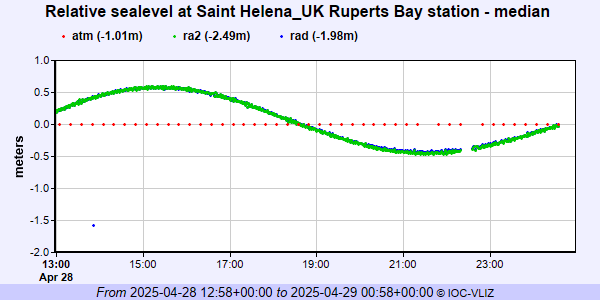 PSMSL Annual Mean Sea Level for '1845' 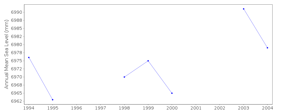 PSMSL Monthly Mean Sea Level for '1845' 
|
|
|