 |
SEALEVEL STATION CATALOG (SSC) |
|
|
|
|
|
| Station catalog metadata [edit] | [station overview] |
|---|
| SSC ID | SSC-sprg | | Station Name | Spring Bay | | Country | Australia | | Latitude | -42.5459 | | Longitude | 147.9327 | | DateLastModified | 2015-10-22 19:02:29 |
| Linked codes |
|---|
| Codes | Location | Latitude | Longitude | Sensors | IOC: sprg | Spring_Bay_AU | -42.5459 | 147.9327 | aqu |
GLOSS: 56 | Spring Bay | -42.55 | 147.93333 | Float, Acoustic |
UHSLC: 335 | Spring Bay | -42.5467 | 147.9317 | N/A |
PTWC: sprg | Spring_Bay_AU | -42.5459 | 147.9327 | prs |
PSMSL: 1216 | SPRING BAY | -42.545861 | 147.932722 | N/A |
PSMSL: 1220 | SPRING BAY II | -42.55 | 147.933333 | N/A |
SONEL_GPS: 2058 | SPRING BAY | -42.54644608 | 147.93084719 | N/A |
SONEL_TG: 2116 | SPRING BAY | -42.54644608 | 147.93084719 | N/A |
| Distributed metadata source: IOC Sea Level Station Monitoring Facility sprg |
|---|
| GTS station code | 61170 |
| GTS message type | SZAU01 |
| Status | Operational |
| Local Contact | National Tidal Centre/Australian Bureau of Meteorology ( Australia ) |
| Connection | GTS message |
| Country | Australia |
| Sensor 1 | |
| Type of sensor | aqu |
| Sampling rate (min) | 1 |
| Distributed metadata source: GLOSS Station Handbook |
|---|
| Time Zone | 150E, GMT + 10hrs | | Ocean | Southern | | Operational | Yes | | Responsible country | Australia | | Data acquisition rate | 6 minute interval | | Additional parameters | Barometric pressure, wind speed and direction, air temperature, water temperature | | Tide gauge benchmarks | Set in the top of a sandstone cliff just N of the gravel road leading to the mill wharf, 21.0m NE of the NE corner of the concrete foundation to a catwalk spanning the conveyors & pipes on the S of the gravel road. | | Benchmark relationships | TGBM (SPM 8521) is 7.236m above AHD and 8.389m above chart datum.
SPM 9258 is 2.529m above AHD and 3.682m above chart datum.
SPM 9257 is 5.843m above AHD and 6.976m above chart datum.
SPM 8522 is 6.919m above AHD and 8.072m above chart datum.
| | Auxiliary benchmarks | SPM9258: on concrete deck of the tide station platform, 0.7m W of the E edge of the platform, 0.2m ESE of SE corner of the tide gauge shelter.
SPM9257: in 1x2m concrete slab near saltwater pump station at the NE end of Freestone Cove, 7.3m SSW of SE corner of the pump shed.
SPM8522: in N side of concrete foundation for a catwalk spanning the conveyors & pipes on S side of gravel road leading to mill wharf.
SPM9258 RM1 3D SEAFRAME Sensor BM is 3.500m above AHD and 4.653m above Chart Datum.
| | Other relevant information | Previous gauges have operated in Hobart since 1889.
Permanent VLBI/GPS station established at Mt. Pleasant Observatory, approx. 12km from the gauge - part of CIGNET.
PSMSL also hold data from another gauge at Spring Bay (PSMSL Code 680/200 1968-1969,1983-1985).
| | Other relevant codes | NTF port no. 61170, UHSLC 335 | | Nearest Met. station | Hobart Meteorogical Office |
| Distributed metadata source: PTWC COMP META file |
| DCP ID | 61170 |
| WMO | SZAU01 |
| Samp Rate | 1 |
| Num# Samp | 6 |
| Unit | M |
| Scale | 1.0000 |
| Xmt Int. | 003 |
| Fst Min. | 0000 |
| HAR | 1 |
| Owner | ABM |
| Distributed metadata source: UHSLC |
| UHSLC id | 335 |
| SSC id | sprg |
| GLOSS id | 56 |
| UHSLC geojson | https://uhslc.soest.hawaii.edu/data/meta.geojson |
| Research quality data version a | 1985-04-12 - 2021-12-31 |
| RQ basin | pacific |
| Fast delivery | 1985-04-12 - 2026-05-31 |
| Distributed metadata source: PSMSL |
| Name | SPRING BAY |
| GLOSS id | 56 |
| UHSLC ID | 335 |
| SONEL id | 2058 |
| Is RLR | Y |
| Has RLR Diagram | Y link |
| QC Flag | N |
| Old ID | 680/199 |
| Last Updated | 2025-03-20 |
| Supplier | NATIONAL TIDAL CENTRE |
| Address | National Tidal Centre, Bureau of Meteorology, PO Box 421, Kent Town 5071, South Australia, AUSTRALIA |
| Metric Start | 1968 |
| Metric End | 2025 |
| Metric Completeness | 69.5 |
| RLR Start | 1992 |
| RLR End | 2025 |
| RLR Completeness | 97.1 |
| Download metric sea level data. | Use only with extreme caution. |
| Name | SPRING BAY II |
| GLOSS id | 56 |
| UHSLC ID | 335 |
| Is RLR | N |
| Has RLR Diagram | N link |
| QC Flag | N |
| Old ID | 680/200 |
| Last Updated | 1993-05-24 |
| Supplier | NATIONAL TIDAL FACILITY |
| Address | National Tidal Facility, G.P.O. Box 2100, S.A. 5001, Adelaide , AUSTRALIA |
| Metric Start | 1968 |
| Metric End | 1989 |
| Metric Completeness | 25.4 |
| Download metric sea level data. | Use only with extreme caution. |
IOC Sea Level Station Monitoring Facility - realtime graph for 'sprg' 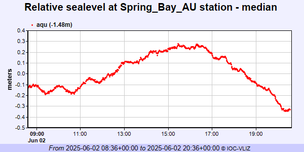 PSMSL Annual Mean Sea Level for '1216' 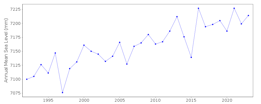 PSMSL Annual Mean Sea Level for '1220'  PSMSL Monthly Mean Sea Level for '1220' 
|
|
|