 |
SEALEVEL STATION CATALOG (SSC) |
|
|
|
|
|
| Station catalog metadata [edit] | [station overview] |
|---|
| SSC ID | SSC-sitk | | Station Name | Sitka | | Country | United States | | Latitude | 57.0517 | | Longitude | -135.3417 | | DateLastModified | 2015-10-22 19:02:29 |
| Distributed metadata source: IOC Sea Level Station Monitoring Facility sitk |
|---|
| Status | Operational |
| Local Contact | National Ocean Service-NOAA ( USA ) |
| Connection | WEB service |
| Country | USA |
| Sensor 1 | |
| Type of sensor | wls |
| Sampling rate (min) | 1 |
| Distributed metadata source: IOC Sea Level Station Monitoring Facility sitk2 |
|---|
| GTS station code | 33A4BA88 |
| GTS message type | SXXX03 |
| Status | Operational |
| Local Contact | National Ocean Service-NOAA ( USA ) |
| Connection | GTS message |
| Country | USA |
| Sensor 1 | |
| Type of sensor | pwl |
| Sampling rate (min) | 1 |
| Distributed metadata source: GLOSS Station Handbook |
|---|
| Time Zone | 135W, GMT - 9hrs | | Ocean | Pacific | | Operational | Yes | | Data acquisition rate | 6 minute intervals | | Tide gauge benchmarks | NOS tidal benchmark survey disk stamped 'TIDAL 26 1974' set in a rock outcrop south of the Russian Block House #1 off of Seward Street in Sitka, AK. | | Benchmark relationships | TGBM = 40.95 feet above mean lower low water (1960-1978 epoch)
TGBM = 35.70 feet above mean sea level (1960-1978 epoch)
TGBM = 31.81 feet above mean high water (1960-1978 epoch)
| | Auxiliary benchmarks | 8 1924 TIDAL BM
1600K 1978 1600 J 1977
16 1941 1600 L 1982
22 1965 No stamping 1
TIDAL 24 1974 TIDAL 25 1974
Site inspection 1993 states 'levels agree with history' and 'BM City continues to show movement over years'
| | Other relevant codes | UHSLC 559 |
| Distributed metadata source: PTWC COMP META file |
| DCP ID | 33A4BA88 |
| WMO | SXXX03 |
| Samp Rate | 6 |
| Num# Samp | 1 |
| Unit | M |
| Scale | 1.0000 |
| Xmt Int. | 006 |
| Fst Min. | 0004 |
| HAR | 1 |
| Owner | NOS |
| Distributed metadata source: UHSLC |
| UHSLC id | 559 |
| SSC id | sitk |
| GLOSS id | 154 |
| UHSLC geojson | https://uhslc.soest.hawaii.edu/data/meta.geojson |
| Research quality data version a | 1938-05-20 - 2021-12-31 |
| RQ basin | pacific |
| Fast delivery | 1938-05-20 - 2026-05-31 |
| Distributed metadata source: PSMSL |
| Name | SITKA |
| GLOSS id | 154 |
| UHSLC ID | 559 |
| SONEL id | 4331 |
| Is RLR | Y |
| Has RLR Diagram | Y link |
| QC Flag | N |
| Old ID | 821/031 |
| Last Updated | 2026-01-28 |
| Supplier | N.O.A.A. / N.O.S. |
| Address | N.O.A.A. / N.O.S., N/oes33, Ssmc4, Room 6531, 1305 East-West Highway, Silver Spring, , MD 20910, UNITED STATES |
| Metric Start | 1938 |
| Metric End | 2025 |
| Metric Completeness | 99.5 |
| RLR Start | 1938 |
| RLR End | 2025 |
| RLR Completeness | 99.5 |
| Download metric sea level data. | Use only with extreme caution. |
IOC Sea Level Station Monitoring Facility - realtime graph for 'sitk' 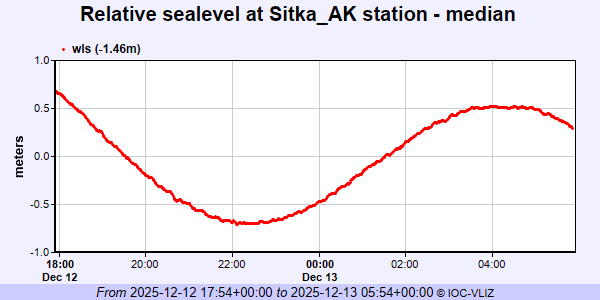 IOC Sea Level Station Monitoring Facility - realtime graph for 'sitk2' 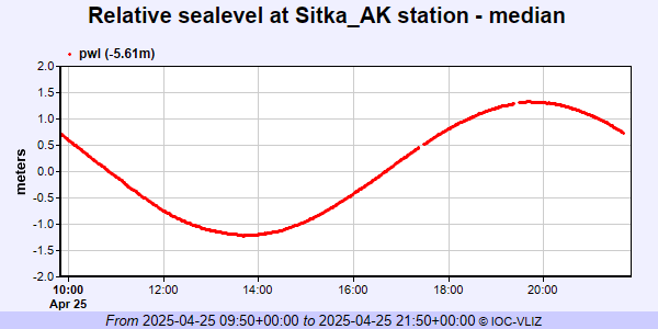 PSMSL Annual Mean Sea Level for '426' 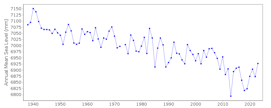 PSMSL Monthly Mean Sea Level for '426' 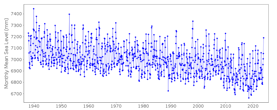
|
|
|