 |
SEALEVEL STATION CATALOG (SSC) |
|
|
|
|
|
| Station catalog metadata [edit] | [station overview] |
|---|
| SSC ID | SSC-scarl | | Station Name | Scarborough | | Country | United Kingdom | | Latitude | 54.283333 | | Longitude | -0.383333 | | DateLastModified | 2015-10-22 19:02:29 |
| Linked codes |
|---|
| Codes | Location | Latitude | Longitude | Sensors | PSMSL: 2417 | SCARBOROUGH | 54.28248 | -0.39027 | N/A |
PSMSL: 946 | SCARBOROUGH | 54.283333 | -0.383333 | N/A |
| Distributed metadata source: PSMSL |
| Name | SCARBOROUGH |
| Is RLR | Y |
| Has RLR Diagram | Y link |
| QC Flag | N |
| Last Updated | 2025-10-01 |
| Supplier | CHANNEL COASTAL OBSERVATORY |
| Address | National Oceanography Centre, Waterfront Campus, European Way, Southampton, UNITED KINGDOM |
| Metric Start | 2013 |
| Metric End | 2024 |
| Metric Completeness | 83.3 |
| RLR Start | 2013 |
| RLR End | 2024 |
| RLR Completeness | 83.3 |
| Download metric sea level data. | Use only with extreme caution. |
| Name | SCARBOROUGH |
| Is RLR | N |
| Has RLR Diagram | N link |
| QC Flag | N |
| Old ID | 170/057 |
| Last Updated | null |
| Supplier | N.O.C. |
| Address | British Oceanographic Data Centre, National Oceanography Centre, Joseph Proudman Building, 6 Brownlow Street, Liverpool, L3 5DA, UNITED KINGDOM |
| Metric Start | 1959 |
| Metric End | 1966 |
| Metric Completeness | 76.0 |
| Download metric sea level data. | Use only with extreme caution. |
PSMSL Annual Mean Sea Level for '2417' 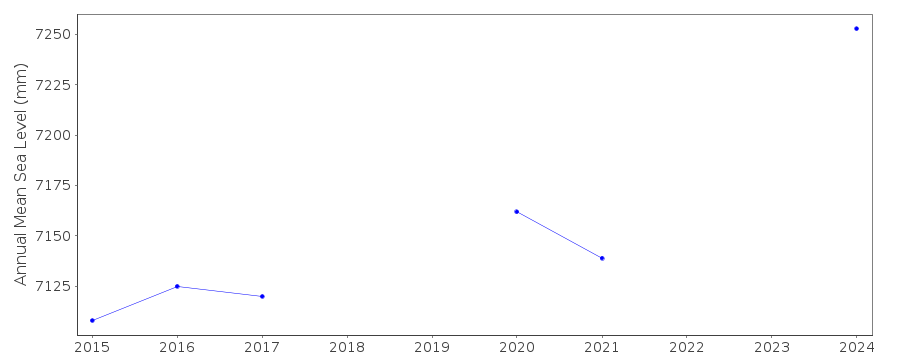 PSMSL Annual Mean Sea Level for '946'  PSMSL Monthly Mean Sea Level for '946' 
|
|
|