| Station catalog metadata [edit] | [station overview] |
|---|
| SSC ID | SSC-sant |
| Station Name | Santa Cruz |
| Country | Ecuador |
| Latitude | -0.752 |
| Longitude | -90.307 |
| DateLastModified | 2015-10-22 19:02:29 |
| Linked codes |
|---|
| Codes | Location | Latitude | Longitude | Sensors |
IOC: sant | SantaCruz,Galapagos | -0.752 | -90.307 | prs, rad, ras, bat, sw1, sw2 |
UHSLC: 30 | Santa Cruz | -0.75521 | -90.31265 | N/A |
PTWC: sant | SantaCruz_Galapagos | -0.7216 | -90.3133 | prs, rad, enc |
PSMSL: 1472 | SANTA CRUZ | -0.75 | -90.316667 | N/A |
SONEL_GPS: 677 | GALAPAGOS ISLAND | -0.74269535 | -90.30361978 | N/A |
SONEL_GPS: 679 | GALAPAGOS ISLAND | -0.74269535 | -90.30361978 | N/A |
SONEL_TG: 1996 | BALTRA | -0.43333301 | -90.28330231 | N/A |
SONEL_TG: 2776 | GALAPAGOS ISLAND | -0.75518200 | -90.31265100 | N/A |
| Distributed metadata source: IOC Sea Level Station Monitoring Facility sant |
|---|
| GTS station code | 932085F0 |
| GTS message type | SEEQ40 |
| Status | Operational |
| Local Contact | Instituto Oceanográfico de la Armada ( Ecuador ) |
| Other Contact | University of Hawaii Sea Level Center ( USA ) |
| Connection | GTS message |
| Country | Ecuador |
| Sensor 1 | |
| Type of sensor | prs |
| Sampling rate (min) | 1 |
| Sensor 2 | |
| Type of sensor | rad |
| Sampling rate (min) | 1 |
| Sensor 3 | |
| Type of sensor | ras |
| Sampling rate (min) | 1 |
| Sensor 4 | |
| Type of sensor | sw1 |
| Sampling rate (min) | 60 |
| Sensor 5 | |
| Type of sensor | sw2 |
| Sampling rate (min) | 60 |
| Sensor 6 | |
| Type of sensor | bat |
| Sampling rate (min) | 5 |
| Distributed metadata source: PTWC COMP META file |
| DCP ID | 932085F0 |
| WMO | SEEQ40 |
| Samp Rate | 5 |
| Num# Samp | 5 |
| Unit | M |
| Scale | 1.0000 |
| Xmt Int. | 060 |
| Fst Min. | 0001 |
| HAR | 1 |
| Owner | UHSLC |
| Distributed metadata source: UHSLC |
| UHSLC id | 030 |
| SSC id | sant |
| UHSLC geojson | https://uhslc.soest.hawaii.edu/data/meta.geojson |
| Research quality data version a | 1978-10-19 - 2024-12-31 |
| RQ basin | pacific |
| Fast delivery | 1978-10-19 - 2026-05-31 |
| Distributed metadata source: PSMSL |
| Name | SANTA CRUZ |
| UHSLC ID | 30 |
| SONEL id | 677 |
| Is RLR | Y |
| Has RLR Diagram | Y link |
| QC Flag | N |
| Old ID | 845/031 |
| Last Updated | 2023-03-07 |
| Supplier | UNIVERSITY OF HAWAII SEA LEVEL CENTER |
| Address | University of Hawaii Sea Level Center, Department of Oceanography Division of Natural Sciences, 1000 Pope Road, Honolulu, Hawaii 96822, UNITED STATES |
| Metric Start | 1978 |
| Metric End | 2018 |
| Metric Completeness | 94.7 |
| RLR Start | 1978 |
| RLR End | 2018 |
| RLR Completeness | 94.7 |
| Download metric sea level data. | Use only with extreme caution. |
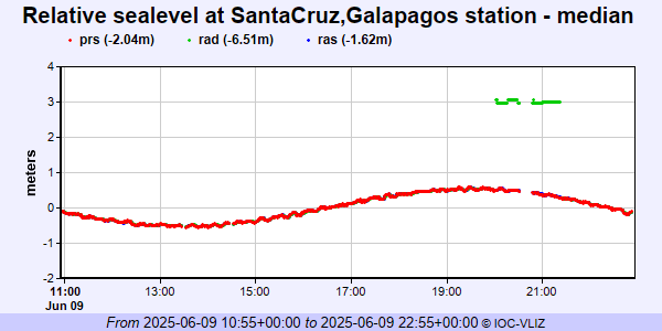
IOC Sea Level Station Monitoring Facility - realtime graph for 'sant'
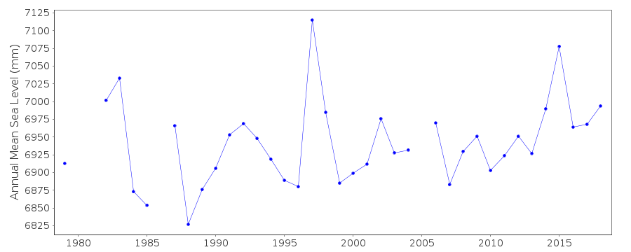
PSMSL Annual Mean Sea Level for '1472'
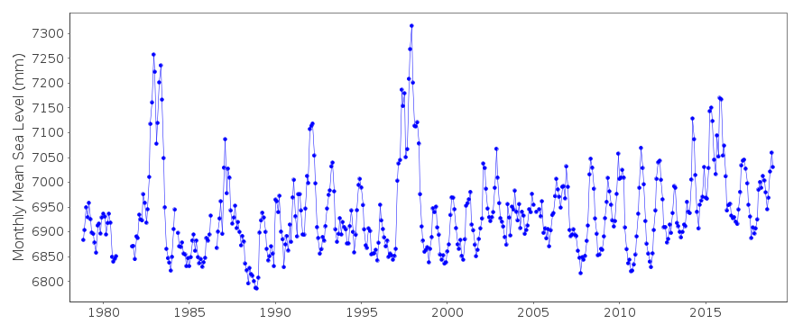
PSMSL Monthly Mean Sea Level for '1472'