 |
SEALEVEL STATION CATALOG (SSC) |
|
|
|
|
|
| Station catalog metadata [edit] | [station overview] |
|---|
| SSC ID | SSC-sanj | | Station Name | San Juan | | Country | United States | | Latitude | 18.4617 | | Longitude | -66.1167 | | DateLastModified | 2015-10-22 19:02:29 |
| Distributed metadata source: IOC Sea Level Station Monitoring Facility sanj |
|---|
| GTS station code | 335CA19E |
| GTS message type | SXXX03 |
| Status | Operational |
| Local Contact | National Ocean Service-NOAA ( USA ) |
| Other Contact | International Tsunami Information Center Caribbean Office ( USA ) |
| Connection | WEB service |
| Country | USA |
| Sensor 1 | |
| Type of sensor | wls |
| Sampling rate (min) | 1 |
| Distributed metadata source: IOC Sea Level Station Monitoring Facility sanj2 |
|---|
| GTS station code | 335CA19E |
| GTS message type | SXXX03 |
| Status | Operational |
| Local Contact | National Ocean Service-NOAA ( USA ) |
| Other Contact | International Tsunami Information Center Caribbean Office ( USA ) |
| Connection | GTS message |
| Country | USA |
| Sensor 1 | |
| Type of sensor | pwl |
| Sampling rate (min) | 1 |
| Distributed metadata source: GLOSS Station Handbook |
|---|
| Time Zone | 060W, GMT - 4hrs | | Ocean | Atlantic | | Operational | Yes | | Data acquisition rate | 6 minute intervals | | Tide gauge benchmarks | NOS tidal benchmark survey disk stamped '5371 A 1977' set in the top of a concrete sea wall at the U.S. Coastguard compound. | | Benchmark relationships | TGBM = 5.32 feet above mean lower low water (1960-1978 epoch)
TGBM = 4.54 feet above mean sea level (1960-1978 epoch)
TGBM = 3.99 feet above mean high water (1960-1978 epoch)
TGBM is 2.600 metres above tide staff zero
| | Auxiliary benchmarks | 5371 B 1977 NO 13 1962
5371 C 1977 NO 14 1962
5371 D 1977 (3.017m above tide staff zero)
5371 E 1977 (3.264m above tide staff zero)
5371 G 1977
5371 F 1977 (3.334m above tide staff zero - removed February 1993)
SJH 44 1991 (2.565m above tide staff zero)
| | Other relevant information | PSMSL hold data from prevoius gauge (PSMSL ref 938/021) from 1962-1974. | | Other relevant codes | UHSLC 245 |
| Distributed metadata source: PTWC COMP META file |
| DCP ID | 335CA19E |
| WMO | SXXX03 |
| Samp Rate | 6 |
| Num# Samp | 1 |
| Unit | M |
| Scale | 1.3401 |
| Xmt Int. | 006 |
| Fst Min. | 0003 |
| HAR | 1 |
| Owner | NOS |
| Distributed metadata source: UHSLC |
| UHSLC id | 245 |
| SSC id | sanj |
| GLOSS id | 206 |
| UHSLC geojson | https://uhslc.soest.hawaii.edu/data/meta.geojson |
| Research quality data version a | 1977-11-29 - 2021-12-31 |
| RQ basin | atlantic |
| Fast delivery | 1977-11-29 - 2026-05-31 |
| Distributed metadata source: PSMSL |
| Name | SAN JUAN |
| GLOSS id | 206 |
| UHSLC ID | 245 |
| SONEL id | 2662 |
| Is RLR | Y |
| Has RLR Diagram | Y link |
| QC Flag | N |
| Old ID | 938/021 |
| Last Updated | 2026-01-28 |
| Supplier | N.O.A.A. / N.O.S. |
| Address | N.O.A.A. / N.O.S., N/oes33, Ssmc4, Room 6531, 1305 East-West Highway, Silver Spring, , MD 20910, UNITED STATES |
| Metric Start | 1962 |
| Metric End | 2025 |
| Metric Completeness | 91.8 |
| RLR Start | 1962 |
| RLR End | 2025 |
| RLR Completeness | 91.8 |
| Download metric sea level data. | Use only with extreme caution. |
IOC Sea Level Station Monitoring Facility - realtime graph for 'sanj' 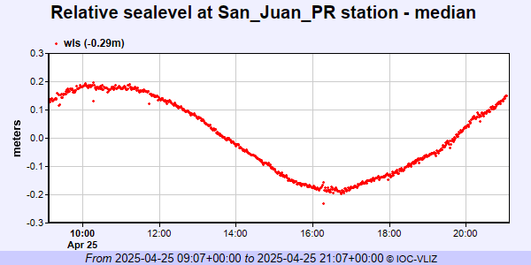 IOC Sea Level Station Monitoring Facility - realtime graph for 'sanj2' 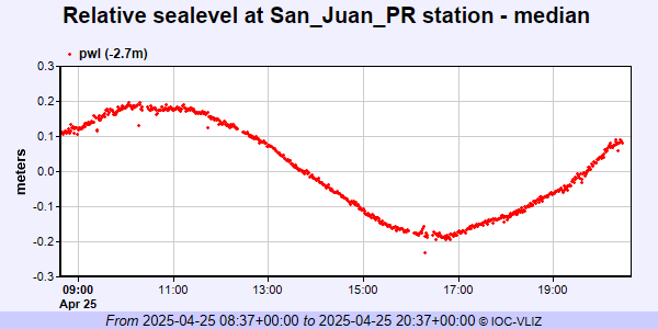 PSMSL Annual Mean Sea Level for '1001'  PSMSL Monthly Mean Sea Level for '1001' 
|
|
|