 |
SEALEVEL STATION CATALOG (SSC) |
|
|
|
|
|
| Station catalog metadata [edit] | [station overview] |
|---|
| SSC ID | SSC-sanf | | Station Name | San Felix | | Country | Chile | | Latitude | -26.258 | | Longitude | -80.124 | | DateLastModified | 2015-10-22 19:02:29 |
| Linked codes |
|---|
| Codes | Location | Latitude | Longitude | Sensors | IOC: sanf | San_Felix_CL | -26.292215 | -80.108548 | prs, rad |
IOC: sanf3 | San_Felix_CL | -26.292215 | -80.108548 | prs, rad |
GLOSS: 177 | San Felix | -26.17 | -80.07 | |
UHSLC: 35 | San Felix | -26.2917 | -80.1083 | N/A |
PTWC: sanf | San_Felix_CL | -26.2922 | -80.1068 | prs, rad |
PSMSL: 1751 | SAN FELIX | -26.292222 | -80.108611 | N/A |
SONEL_TG: 2857 | SAN FELIX | -26.29222200 | -80.10861100 | N/A |
| Distributed metadata source: IOC Sea Level Station Monitoring Facility sanf |
|---|
| GTS station code | ADC09D8E |
| GTS message type | SXCH40 |
| Status | Operational |
| Local Contact | Servicio Hidrográfico y Oceanográfico de la Armada ( Chile ) |
| Other Contact | Servicio Hidrográfico y Oceanográfico de la Armada ( Chile ) |
| Connection | GTS message |
| Country | Chile |
| Sensor 1 | |
| Type of sensor | prs |
| Sampling rate (min) | 1 |
| Sensor 2 | |
| Type of sensor | rad |
| Sampling rate (min) | 1 |
| Distributed metadata source: IOC Sea Level Station Monitoring Facility sanf3 |
|---|
| Status | Operational |
| Local Contact | Servicio Hidrográfico y Oceanográfico de la Armada ( Chile ) |
| Connection | WEB service |
| Country | Chile |
| Sensor 1 | |
| Type of sensor | prs |
| Sampling rate (min) | 1 |
| Sensor 2 | |
| Type of sensor | rad |
| Sampling rate (min) | 1 |
| Distributed metadata source: GLOSS Station Handbook |
|---|
| Time Zone | 060W, GMT - 4hrs | | Ocean | Pacific | | Operational | Yes | | Responsible country | Chile | | Data acquisition rate | 2 minute intervals | | Additional parameters | Sea temperature (hourly)
Air temperature (hourly)
Atmospheric pressure (hourly) | | Tide gauge benchmarks | BM No. 3: it is a bronze disk stamped CF III, set in cement in bedrock platform where the boat landing. | | Benchmark relationships | BM No. 3 (1987-2003)
BM Doppler (1984-1997) | | Other relevant information | Levelling twice a year
No GPS recording | | Other relevant codes | UHSLC 035 |
| Distributed metadata source: PTWC COMP META file |
| DCP ID | ADC09D8E |
| WMO | SXCH40 |
| Samp Rate | 1 |
| Num# Samp | 5 |
| Unit | M |
| Scale | 1.0000 |
| Xmt Int. | 005 |
| Fst Min. | 0000 |
| HAR | 1 |
| Owner | SHOA |
| Distributed metadata source: UHSLC |
| UHSLC id | 035 |
| SSC id | sanf |
| GLOSS id | 177 |
| UHSLC geojson | https://uhslc.soest.hawaii.edu/data/meta.geojson |
| Research quality data version a | 1987-11-06 - 2018-12-31 |
| RQ basin | pacific |
| Fast delivery | 1987-11-06 - 2026-05-31 |
| Distributed metadata source: PSMSL |
| Name | SAN FELIX |
| GLOSS id | 177 |
| UHSLC ID | 35 |
| Is RLR | Y |
| Has RLR Diagram | Y link |
| QC Flag | N |
| Old ID | 850/016 |
| Last Updated | 2025-06-09 |
| Supplier | HYDROGRAPHIC AND OCEANOGRAPHIC SERVICE OF THE CHILEAN NAVY |
| Address | Hydrographic and Oceanographic Service of the Chilean Navy, Errazuriz 254, Playa Ancha , Valparaiso, CHILE |
| Metric Start | 1989 |
| Metric End | 2024 |
| Metric Completeness | 82.2 |
| RLR Start | 1989 |
| RLR End | 2024 |
| RLR Completeness | 82.2 |
| Download metric sea level data. | Use only with extreme caution. |
IOC Sea Level Station Monitoring Facility - realtime graph for 'sanf' 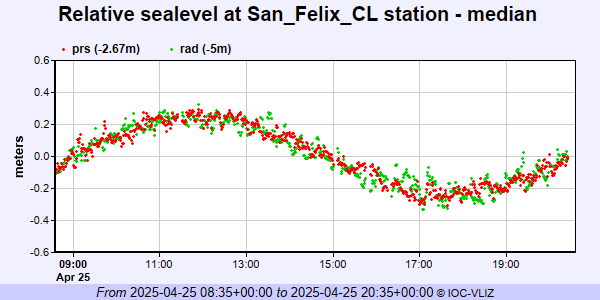 IOC Sea Level Station Monitoring Facility - realtime graph for 'sanf3' 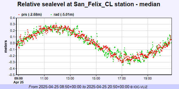 PSMSL Annual Mean Sea Level for '1751' 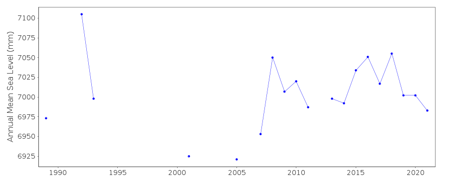 PSMSL Monthly Mean Sea Level for '1751' 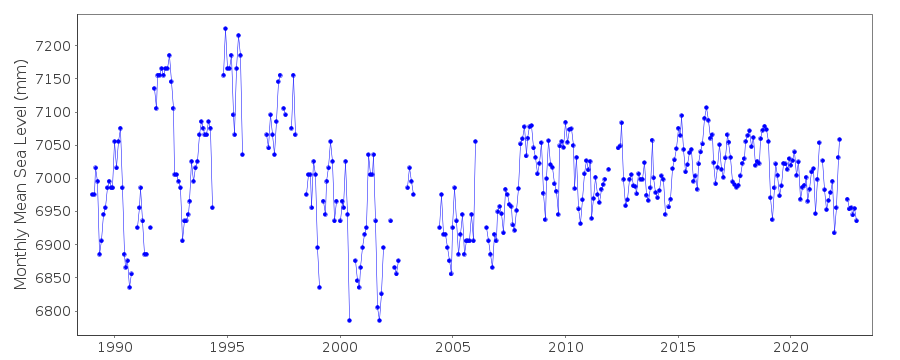
|
|
|