 |
SEALEVEL STATION CATALOG (SSC) |
|
|
|
|
|
| Station catalog metadata [edit] | [station overview] |
|---|
| SSC ID | SSC-sala | | Station Name | Salalah | | Country | Oman | | Latitude | 16.935 | | Longitude | 54.0067 | | DateLastModified | 2015-10-22 19:02:29 |
| Linked codes |
|---|
| Codes | Location | Latitude | Longitude | Sensors | IOC: sala | Salalah | 16.935 | 54.0067 | rad, prs, enc, bat, enb, sw1, sw2 |
GLOSS: 4 | Salalah | 17 | 54 | Float |
UHSLC: 114 | Salalah | 16.935 | 54.0067 | N/A |
PTWC: sala | Salalah_OM | 16.9354 | 54.0074 | prs, rad, enc |
PSMSL: 1754 | SALALAH | 16.933333 | 54.0 | N/A |
SONEL_TG: 2791 | SALALAH | 16.93536900 | 54.00741400 | N/A |
| Distributed metadata source: IOC Sea Level Station Monitoring Facility sala |
|---|
| GTS station code | 1605C096 |
| GTS message type | SXXX33 |
| Status | Operational |
| Local Contact | Directorate General Meteorology and Air Navigation ( Oman ) |
| Connection | GTS message |
| Country | Oman |
| Sensor 1 | |
| Type of sensor | prs |
| Sampling rate (min) | 1 |
| Sensor 2 | |
| Type of sensor | rad |
| Sampling rate (min) | 1 |
| Sensor 3 | |
| Type of sensor | bat |
| Sampling rate (min) | 6 |
| Sensor 4 | |
| Type of sensor | enb |
| Sampling rate (min) | 6 |
| Sensor 5 | |
| Type of sensor | enc |
| Sampling rate (min) | 6 |
| Sensor 6 | |
| Type of sensor | sw1 |
| Sampling rate (min) | 60 |
| Sensor 7 | |
| Type of sensor | sw2 |
| Sampling rate (min) | 60 |
| Distributed metadata source: GLOSS Station Handbook |
|---|
| Time Zone | 060E, GMT + 4hrs | | Ocean | Indian | | Operational | Yes | | Responsible country | Oman | | Additional parameters | Tide staff reading twice/day at 0645 and 1845 | | Tide gauge benchmarks | RP stainless steel 1 inch square plate glued with white epoxy to the centre of the tide gauge pedestal (formerly called the tide gauge reference plate) - 3.030m above Mean Sea Level (MSL) (10/12/96) | | Auxiliary benchmarks | UH1 - stainless steel 1 inch square plate set in white epoxy at the left corner of the bottom step of the Met. stairwell - 3.992m above MSL (10/12/96)
0907 - round brass survey plate, with Omani shield in Arabic, east front corner foundation step of Police Building with the marking 16932 0979 - 3.722m above MSL (10/12/96)
UH2 - stainless steel 1 inch square plate set in white epoxy on the east side of the second step of the bunker ruins east of the tide gauge and 21.3m east of UH1, near the oil line marker - 4.657m above MSL (10/12/96)
UH3 - stainless steel 1 inch square plate glued with epoxy, not stamped, in the north east corner of the cement base of the third lamp post to the west of the tide gauge - 3.420m above MSL (10/12/96)
| | Other relevant information | Tide gauge, float sensed electromechanical recorder, installed by the University of Hawaii.
Previous tide gauge was electronic pressority and was inefficient and unreliable. It was taken out of service when beyond economical repair.
| | Other relevant codes | UHSLC 114 | | Nearest Met. station | Raysut Met. Office |
| Distributed metadata source: PTWC COMP META file |
| DCP ID | 1605C096 |
| WMO | SXXX33 |
| Samp Rate | 6 |
| Num# Samp | 10 |
| Unit | M |
| Scale | 1.0000 |
| Xmt Int. | 006 |
| Fst Min. | 0001 |
| HAR | 1 |
| Owner | UHSLC |
| Distributed metadata source: UHSLC |
| UHSLC id | 114 |
| SSC id | sala |
| GLOSS id | 4 |
| UHSLC geojson | https://uhslc.soest.hawaii.edu/data/meta.geojson |
| Research quality data version a | 1989-10-01 - 2018-05-23 |
| RQ basin | indian |
| Fast delivery | 1989-10-01 - 2026-05-31 |
| Distributed metadata source: PSMSL |
| Name | SALALAH |
| GLOSS id | 4 |
| UHSLC ID | 114 |
| Is RLR | Y |
| Has RLR Diagram | Y link |
| QC Flag | N |
| Old ID | 487/001 |
| Last Updated | 2020-01-29 |
| Supplier | UNIVERSITY OF HAWAII SEA LEVEL CENTER |
| Address | University of Hawaii Sea Level Center, Department of Oceanography Division of Natural Sciences, 1000 Pope Road, Honolulu, Hawaii 96822, UNITED STATES |
| Metric Start | 1989 |
| Metric End | 2018 |
| Metric Completeness | 81.1 |
| RLR Start | 1994 |
| RLR End | 2018 |
| RLR Completeness | 59.7 |
| Download metric sea level data. | Use only with extreme caution. |
IOC Sea Level Station Monitoring Facility - realtime graph for 'sala' 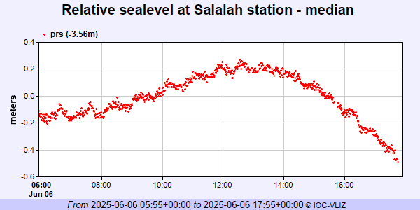 PSMSL Annual Mean Sea Level for '1754' 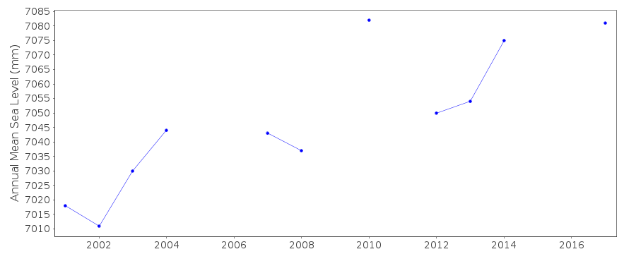 PSMSL Monthly Mean Sea Level for '1754' 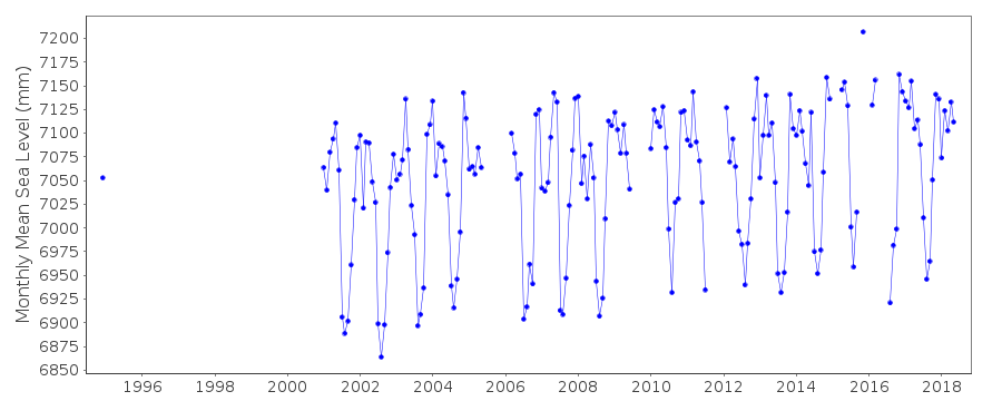
|
|
|