 |
SEALEVEL STATION CATALOG (SSC) |
|
|
|
|
|
| Station catalog metadata [edit] | [station overview] |
|---|
| SSC ID | SSC-roth | | Station Name | Rothera | | Country | United Kingdom | | Latitude | -67.56666 | | Longitude | -68.13333 | | DateLastModified | 2015-10-22 19:02:29 |
| Linked codes |
|---|
| Codes | Location | Latitude | Longitude | Sensors | IOC: rothe | Rothera | -67.5667 | -68.1333 | rad, pr1, pr2, atm, bat |
GLOSS: 342 | Rothera | -67.57166 | -68.12833 | |
UHSLC: 832 | Rothera | -67.5667 | -68.1333 | N/A |
PTWC: roth | Rothera_Antarctica | -67.5667 | -68.1333 | pr1, pr2, rad |
PSMSL: 1931 | ROTHERA | -67.571256 | -68.129797 | N/A |
SONEL_GPS: 2007 | ROTHERA | -67.57140350 | -68.12574768 | N/A |
SONEL_TG: 1991 | ROTHERA | -67.57144900 | -68.12855100 | N/A |
| Distributed metadata source: IOC Sea Level Station Monitoring Facility rothe |
|---|
| GTS station code | 6B000D98 |
| GTS message type | SEMS40 |
| Status | Operational |
| Local Contact | British Antartic Survey ( UK ) |
| Other Contact | National Oceanography Centre ( UK ) |
| Connection | GTS message |
| Country | Antarctica |
| Sensor 1 | |
| Type of sensor | rad |
| Sampling rate (min) | 1 |
| Sensor 2 | |
| Type of sensor | pr1 |
| Sampling rate (min) | 1 |
| Sensor 3 | |
| Type of sensor | pr2 |
| Sampling rate (min) | 1 |
| Sensor 4 | |
| Type of sensor | atm |
| Sampling rate (min) | 15 |
| Sensor 5 | |
| Type of sensor | bat |
| Sampling rate (min) | 15 |
| Distributed metadata source: GLOSS Station Handbook |
|---|
| Time Zone | GMT-3 hrs | | Additional parameters | Sea Temperature, Logger Temperature, Well Temperature, Atmospheric Pressure | | Benchmark relationships | RLR is 10.923 m below Well Head BM.
For data 2002- add 7.00m to refer to RLR (2002) |
| Distributed metadata source: PTWC COMP META file |
| DCP ID | 6B000D98 |
| WMO | SEMS40 |
| Samp Rate | 1 |
| Num# Samp | 15 |
| Unit | M |
| Scale | 1.0000 |
| Xmt Int. | 015 |
| Fst Min. | 0008 |
| HAR | 1 |
| Owner | NOC |
| Distributed metadata source: UHSLC |
| UHSLC id | 832 |
| SSC id | roth |
| GLOSS id | 342 |
| UHSLC geojson | https://uhslc.soest.hawaii.edu/data/meta.geojson |
| Research quality data version a | 2002-12-23 - 2018-09-06 |
| RQ basin | atlantic |
| Distributed metadata source: PSMSL |
| Name | ROTHERA |
| GLOSS id | 342 |
| UHSLC ID | 832 |
| SONEL id | 2007 |
| Is RLR | Y |
| Has RLR Diagram | Y link |
| QC Flag | N |
| Old ID | 999/103 |
| Last Updated | 2019-06-11 |
| Supplier | N.O.C. |
| Address | British Oceanographic Data Centre, National Oceanography Centre, Joseph Proudman Building, 6 Brownlow Street, Liverpool, L3 5DA, UNITED KINGDOM |
| Metric Start | 2003 |
| Metric End | 2018 |
| Metric Completeness | 89.1 |
| RLR Start | 2003 |
| RLR End | 2018 |
| RLR Completeness | 89.1 |
| Download metric sea level data. | Use only with extreme caution. |
IOC Sea Level Station Monitoring Facility - realtime graph for 'rothe' 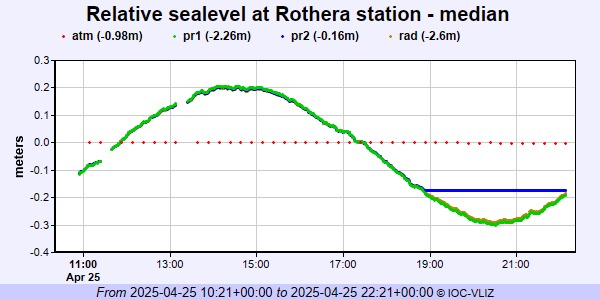 PSMSL Annual Mean Sea Level for '1931' 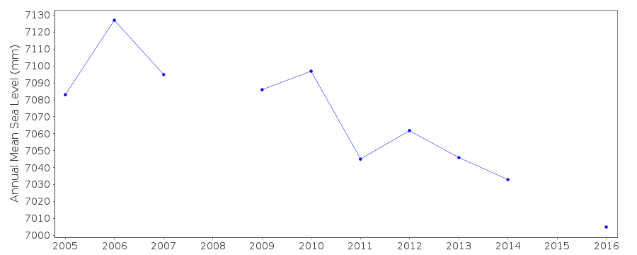 PSMSL Monthly Mean Sea Level for '1931' 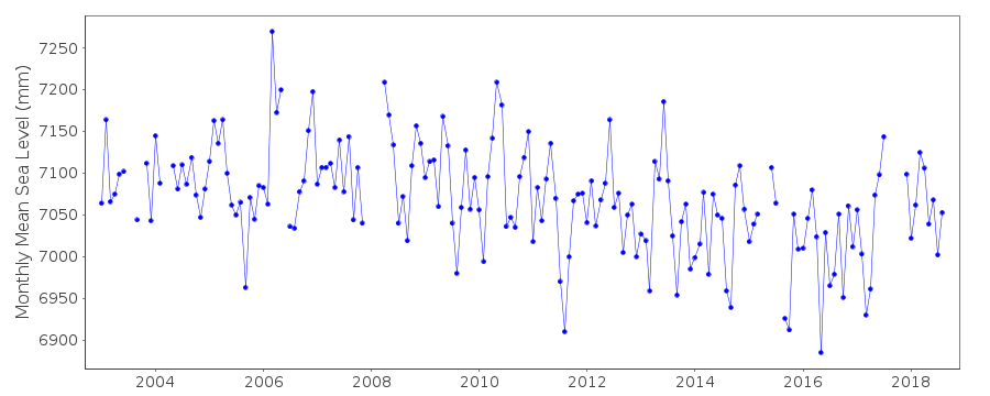
|
|
|