 |
SEALEVEL STATION CATALOG (SSC) |
|
|
|
|
|
| Station catalog metadata [edit] | [station overview] |
|---|
| SSC ID | SSC-rorv | | Station Name | Rørvik | | Country | Norway | | Latitude | 64.866667 | | Longitude | 11.25 | | DateLastModified | 2015-10-22 19:02:29 |
| Distributed metadata source: IOC Sea Level Station Monitoring Facility rorv |
|---|
| Status | Operational |
| Local Contact | Norwegian Hydrographic Service ( Norway ) |
| Connection | WEB service |
| Country | Norway |
| Sensor 1 | |
| Type of sensor | flt |
| Sampling rate (min) | 10 |
| Distributed metadata source: GLOSS Station Handbook |
|---|
| Time Zone | 015E, GMT + 1hr | | Ocean | Atlantic | | Operational | Yes | | Responsible country | Norway | | Additional parameters | Barometric pressure, water level control parameter | | Tide gauge benchmarks | TGBM: H20 N61 | | Benchmark relationships | TGZ: 7.077 m below TGBM | | Auxiliary benchmarks | Auxiliary BM: H20 N60: 3.100 m above TGBM
Normalnull 1954: 5.782 m below TGBM | | Nearest Met. station | Local Airport |
| Distributed metadata source: UHSLC |
| UHSLC id | 803 |
| SSC id | rorv |
| GLOSS id | 234 |
| UHSLC geojson | https://uhslc.soest.hawaii.edu/data/meta.geojson |
| Research quality data version a | 1969-08-18 - 2018-12-31 |
| RQ basin | atlantic |
| Fast delivery | 1969-08-18 - 2026-05-31 |
| Distributed metadata source: PSMSL |
| Name | RORVIK |
| GLOSS id | 234 |
| UHSLC ID | 803 |
| SONEL id | 3561 |
| Is RLR | Y |
| Has RLR Diagram | Y link |
| QC Flag | N |
| Old ID | 040/136 |
| Last Updated | 2026-01-30 |
| Supplier | NORWEGIAN MAPPING AUTHORITY |
| Address | Norwegian Mapping Authority, Hydrographic Service , Po. Box 60, 4001 Stavanger, NORWAY |
| Metric Start | 1969 |
| Metric End | 2025 |
| Metric Completeness | 98.1 |
| RLR Start | 1969 |
| RLR End | 2025 |
| RLR Completeness | 98.1 |
| Download metric sea level data. | Use only with extreme caution. |
IOC Sea Level Station Monitoring Facility - realtime graph for 'rorv' 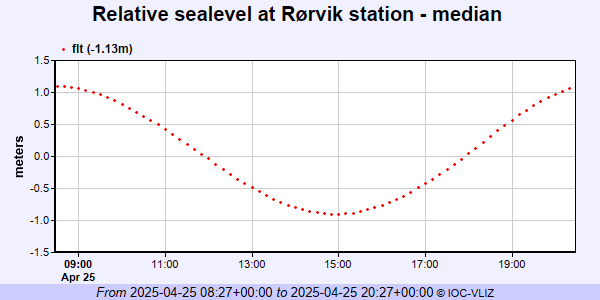 PSMSL Annual Mean Sea Level for '1241' 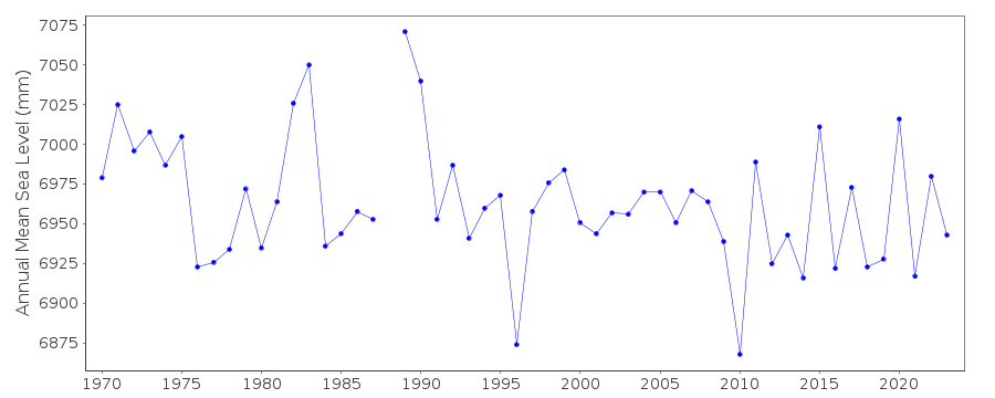 PSMSL Monthly Mean Sea Level for '1241' 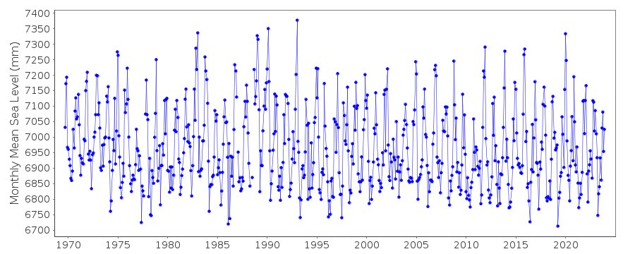
|
|
|