 |
SEALEVEL STATION CATALOG (SSC) |
|
|
|
|
|
| Station catalog metadata [edit] | [station overview] |
|---|
| SSC ID | SSC-rodr | | Station Name | Rodrigues Island | | Country | Mauritius | | Latitude | -19.68024 | | Longitude | 63.42119 | | DateLastModified | 2015-10-22 19:02:29 |
| Linked codes |
|---|
| Codes | Location | Latitude | Longitude | Sensors | IOC: rodr | Rodrigues | -19.68024 | 63.42119 | rad, prs, enc, bat, sw1, sw2, enb |
GLOSS: 19 | Rodrigues, Port Mathurin | -19.68333 | 63.41666 | Float |
UHSLC: 105 | Rodrigues | -19.68032 | 63.4212 | N/A |
PTWC: rodr | Rodrigue_MU | -19.6803 | 63.4215 | prs, rad, enb, enc |
PSMSL: 1672 | RODRIGUES IS | -19.666667 | 63.416667 | N/A |
SONEL_GPS: 2558 | RODRIGUES ISLAND | -19.68115003 | 63.42625054 | N/A |
SONEL_TG: 2557 | RODRIGUES ISLAND | -19.68026700 | 63.42148300 | N/A |
| Distributed metadata source: IOC Sea Level Station Monitoring Facility rodr |
|---|
| GTS station code | 16590056 |
| GTS message type | SXXX32 |
| Status | Operational |
| Local Contact | Mauritius Meteorological Services ( Mauritius ) |
| Other Contact | University of Hawaii Sea Level Center ( USA ) |
| Connection | GTS message |
| Country | Mauritius |
| Sensor 1 | |
| Type of sensor | prs |
| Sampling rate (min) | 1 |
| Sensor 2 | |
| Type of sensor | rad |
| Sampling rate (min) | 1 |
| Sensor 3 | |
| Type of sensor | enc |
| Sampling rate (min) | 6 |
| Sensor 4 | |
| Type of sensor | enb |
| Sampling rate (min) | 6 |
| Sensor 5 | |
| Type of sensor | sw1 |
| Sampling rate (min) | 60 |
| Sensor 6 | |
| Type of sensor | sw2 |
| Sampling rate (min) | 60 |
| Sensor 7 | |
| Type of sensor | bat |
| Sampling rate (min) | 6 |
| Distributed metadata source: GLOSS Station Handbook |
|---|
| Time Zone | 060E, GMT + 4hrs | | Ocean | Indian | | Operational | Yes | | Responsible country | Mauritius | | Additional parameters | Mean Sea Level pressure | | Tide gauge benchmarks | Zero of tide gauge: A bolt at the edge of the wharf of the tide gauge | | Benchmark relationships | Zero of tide staff tied to benchmark which is a point on Beam XII which is adjacent to tide gauge station. The height of the beam is 1.98m above mean sea level. | | Auxiliary benchmarks | 1. Brass tube fixed on a wall in marine service area about 200m from the tide gauge station
2. One benchmark located near the entrance of the Port.
| | Other relevant information | Daily values calculated using 119-point convolution filter (Bloomfield, 1976) centred on noon applied to the hourly data with respective periods of the 95, 50 and 5% amplitude points at 124.0, 60.2 and 40.2 hours. | | Other relevant codes | UHSLC 105 | | Nearest Met. station | Pointe Canon Met. Station |
| Distributed metadata source: PTWC COMP META file |
| DCP ID | 16590056 |
| WMO | SXXX32 |
| Samp Rate | 6 |
| Num# Samp | 10 |
| Unit | M |
| Scale | 1.0000 |
| Xmt Int. | 006 |
| Fst Min. | 0003 |
| HAR | 1 |
| Owner | UHSLC |
| Distributed metadata source: UHSLC |
| UHSLC id | 105 |
| SSC id | rodr |
| GLOSS id | 19 |
| UHSLC geojson | https://uhslc.soest.hawaii.edu/data/meta.geojson |
| Research quality data version a | 1986-11-08 - 2017-09-04 |
| RQ basin | indian |
| Fast delivery | 1986-11-08 - 2026-05-31 |
| Distributed metadata source: PSMSL |
| Name | RODRIGUES IS |
| GLOSS id | 19 |
| UHSLC ID | 105 |
| SONEL id | 2558 |
| Is RLR | Y |
| Has RLR Diagram | Y link |
| QC Flag | N |
| Old ID | 450/021 |
| Last Updated | 2026-01-23 |
| Supplier | METEOROLOGICAL SERVICES, MAURITIUS |
| Address | Meteorological Services, Meteorological Services Headquarters, St. Paul Road, Vacoas, MAURITIUS |
| Metric Start | 1986 |
| Metric End | 2025 |
| Metric Completeness | 92.3 |
| RLR Start | 1986 |
| RLR End | 2025 |
| RLR Completeness | 92.3 |
| Download metric sea level data. | Use only with extreme caution. |
IOC Sea Level Station Monitoring Facility - realtime graph for 'rodr' 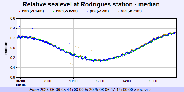 PSMSL Annual Mean Sea Level for '1672'  PSMSL Monthly Mean Sea Level for '1672' 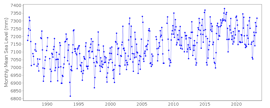
|
|
|