 |
SEALEVEL STATION CATALOG (SSC) |
|
|
|
|
|
| Station catalog metadata [edit] | [station overview] |
|---|
| SSC ID | SSC-raba | | Station Name | Rabaul | | Country | Papua New Guinea | | Latitude | -4.2 | | Longitude | 152.175 | | DateLastModified | 2015-10-22 19:02:29 |
| Distributed metadata source: IOC Sea Level Station Monitoring Facility raba |
|---|
| GTS station code | 354084BC |
| GTS message type | SRUS40 |
| Status | Down |
| Country | Papua New Guinea |
| Distributed metadata source: GLOSS Station Handbook |
|---|
| Time Zone | 150E, GMT + 10hrs | | Ocean | Pacific | | Operational | Yes | | Data acquisition rate | 15 minute intervals | | Tide gauge benchmarks | BM RL 303 A Department of Lands and Survey brass plate, with pin, stamped 'RL No 303' at the north east corner of the old copra, north of Wreck Wharf, 300 yards from tide gauge. | | Benchmark relationships | Tide Gauge Zero (TGZ) = 2.996m below TGBM (Apr 1978)
Chart Datum = 3.057m below US C&GS BM 1
Chart Datum = 1.503m below 'Moresby 1941' benchmark
| | Auxiliary benchmarks | BM RL 431 A Dept. of Lands & Survey brass plate with pin, stamped 'RL No 431', at the corner of Malaguna Road and Coastwatchers Road, north west side of centre island along top of curbing.
UH-1 A stainless steel disc 1.25 inches in diameter set in white epoxy, established by the Oceanography Dept., University of Hawaii, 4 foot north of tide staff, at centre of the curb, on Main Wharf.
| | Other relevant information | Other benchmarks:
US C&GS BM 1 A standard brass US C&GS benchmark, marked 'No.1 1948', set in the top of a low stone wall at the seaward end of Namanula Street.
Moresby BM 1941 The centre of a standard RAN hydrographic Branch circular brass triangulation plate marked 'HMAS Moresby 1941', set into a stone seawall by the swimming pool at the seaward end of Namanula St.
| | Other relevant codes | UHSLC 010, NTF port no. 56200 |
| Distributed metadata source: PTWC COMP META file |
| DCP ID | |
| WMO | |
| Samp Rate | |
| Num# Samp | |
| Unit | |
| Scale | |
| Xmt Int. | |
| Fst Min. | |
| HAR | |
| Owner | |
| Distributed metadata source: UHSLC |
| UHSLC id | 010 |
| SSC id | raba |
| GLOSS id | 65 |
| UHSLC geojson | https://uhslc.soest.hawaii.edu/data/meta.geojson |
| Research quality data version a | 1966-04-06 - 1997-12-31 |
| RQ basin | pacific |
| Distributed metadata source: PSMSL |
| Name | RABAUL |
| GLOSS id | 65 |
| UHSLC ID | 10 |
| SONEL id | 4149 |
| Is RLR | Y |
| Has RLR Diagram | Y link |
| QC Flag | Y |
| Old ID | 670/021 |
| Last Updated | 1998-12-08 |
| Supplier | UNIVERSITY OF HAWAII SEA LEVEL CENTER |
| Address | University of Hawaii Sea Level Center, Department of Oceanography Division of Natural Sciences, 1000 Pope Road, Honolulu, Hawaii 96822, UNITED STATES |
| Metric Start | 1966 |
| Metric End | 1997 |
| Metric Completeness | 82.6 |
| RLR Start | 1966 |
| RLR End | 1997 |
| RLR Completeness | 82.6 |
| Download metric sea level data. | Use only with extreme caution. |
| Name | RABAUL II |
| GLOSS id | 65 |
| UHSLC ID | 10 |
| Is RLR | N |
| Has RLR Diagram | N link |
| QC Flag | N |
| Old ID | 670/022 |
| Last Updated | 1993-05-24 |
| Supplier | NATIONAL TIDAL FACILITY |
| Address | National Tidal Facility, G.P.O. Box 2100, S.A. 5001, Adelaide , AUSTRALIA |
| Metric Start | 1966 |
| Metric End | 1978 |
| Metric Completeness | 51.3 |
| Download metric sea level data. | Use only with extreme caution. |
IOC Sea Level Station Monitoring Facility - realtime graph for 'raba'  PSMSL Annual Mean Sea Level for '1164' 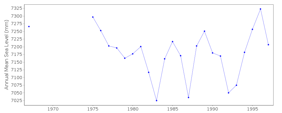 PSMSL Annual Mean Sea Level for '1185'  PSMSL Monthly Mean Sea Level for '1185' 
|
|
|