 |
SEALEVEL STATION CATALOG (SSC) |
|
|
|
|
|
| Station catalog metadata [edit] | [station overview] |
|---|
| SSC ID | SSC-quar | | Station Name | Quarry Bay | | Country | Hong Kong | | Latitude | 22.28333 | | Longitude | 114.21666 | | DateLastModified | 2015-10-22 19:02:29 |
| Distributed metadata source: IOC Sea Level Station Monitoring Facility quar |
|---|
| GTS station code | QUARYBAY |
| GTS message type | SEHK40 |
| Status | Operational |
| Local Contact | Hong Kong Observatory ( Hong Kong - China ) |
| Connection | GTS message |
| Country | Hong Kong - China |
| Sensor 1 | |
| Type of sensor | flt |
| Sampling rate (min) | 1 |
| Distributed metadata source: GLOSS Station Handbook |
|---|
| Time Zone | 120E, GMT + 8hrs | | Ocean | Pacific | | Operational | Yes | | Additional parameters | None | | Tide gauge benchmarks | Bench mark bolt next to tide gauge | | Benchmark relationships | Tide gauge zero (TGZ) = Admiralty chart datum.
TGZ = 5.58m below the fundamental benchmarks which are derived and established from the Rifleman Copper Bolt
| | Auxiliary benchmarks | Local benchmarks are installed near the tide stations. The local benchmarks are surveyed twice a year to check if there is any land settlement that may affect the tidal readings. | | Other relevant information | Quarry Bay tide station is relocated from North Point tide station.
North Point tide station, Location: 22deg 18minN 114deg 12minE (PSMSL Code 611/011)
Observation period: 1950 -1985
Data held by PSMSL: 1950 - 1985 (also 1929 - 1930 from earlier gauge)
| | Nearest Met. station | Royal Observatory Hong Kong |
| Distributed metadata source: PTWC COMP META file |
| DCP ID | QUARYBAY |
| WMO | SEHK40 |
| Samp Rate | 1 |
| Num# Samp | 20 |
| Unit | M |
| Scale | 1.0000 |
| Xmt Int. | 010 |
| Fst Min. | 0005 |
| HAR | 1 |
| Owner | HKO |
| Distributed metadata source: UHSLC |
| UHSLC id | 329 |
| SSC id | quar |
| GLOSS id | 77 |
| UHSLC geojson | https://uhslc.soest.hawaii.edu/data/meta.geojson |
| Research quality data version a | 1962-01-01 - 1985-12-31 |
| Research quality data version b | 1986-01-01 - 2024-12-31 |
| RQ basin | pacific |
| Fast delivery | 1986-01-01 - 2026-05-31 |
| Distributed metadata source: PSMSL |
| Name | QUARRY BAY |
| GLOSS id | 77 |
| UHSLC ID | 329 |
| SONEL id | 2089 |
| Is RLR | Y |
| Has RLR Diagram | Y link |
| QC Flag | N |
| Old ID | 611/010 |
| Last Updated | 2026-05-20 |
| Supplier | HONG KONG OBSERVATORY |
| Address | Hong Kong Observatory, 134A Nathan Road, Kowloon, HONG KONG |
| Metric Start | 1986 |
| Metric End | 2025 |
| Metric Completeness | 100.0 |
| RLR Start | 1986 |
| RLR End | 2025 |
| RLR Completeness | 100.0 |
| Download metric sea level data. | Use only with extreme caution. |
| Name | TAMAR |
| UHSLC ID | 329 |
| Is RLR | N |
| Has RLR Diagram | N link |
| QC Flag | N |
| Old ID | 611/009 |
| Last Updated | 1991-09-13 |
| Supplier | HONG KONG OBSERVATORY |
| Address | Hong Kong Observatory, 134A Nathan Road, Kowloon, HONG KONG |
| Metric Start | 1986 |
| Metric End | 1990 |
| Metric Completeness | 61.7 |
| Download metric sea level data. | Use only with extreme caution. |
| Name | TAI MIU WAN |
| UHSLC ID | 329 |
| SONEL id | 2089 |
| Is RLR | Y |
| Has RLR Diagram | Y link |
| QC Flag | N |
| Old ID | 611/012 |
| Last Updated | 2026-05-20 |
| Supplier | HONG KONG OBSERVATORY |
| Address | Hong Kong Observatory, 134A Nathan Road, Kowloon, HONG KONG |
| Metric Start | 1997 |
| Metric End | 2025 |
| Metric Completeness | 94.8 |
| RLR Start | 1997 |
| RLR End | 2025 |
| RLR Completeness | 94.8 |
| Download metric sea level data. | Use only with extreme caution. |
| Name | NORTH POINT |
| GLOSS id | 77 |
| UHSLC ID | 329 |
| SONEL id | 2089 |
| Is RLR | Y |
| Has RLR Diagram | Y link |
| QC Flag | N |
| Old ID | 611/011 |
| Last Updated | null |
| Supplier | PORT WORKS DIVISION, HONG KONG |
| Address | Port Works Division, 4 - 5/f, Civil Engineering Building, 101 Princess Margaret Road, Homantin, Kowloon, HONG KONG |
| Metric Start | 1929 |
| Metric End | 1985 |
| Metric Completeness | 64.0 |
| RLR Start | 1929 |
| RLR End | 1985 |
| RLR Completeness | 64.0 |
| Download metric sea level data. | Use only with extreme caution. |
IOC Sea Level Station Monitoring Facility - realtime graph for 'quar' 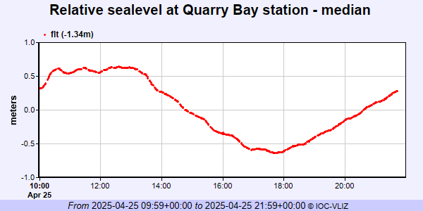 PSMSL Annual Mean Sea Level for '1674' 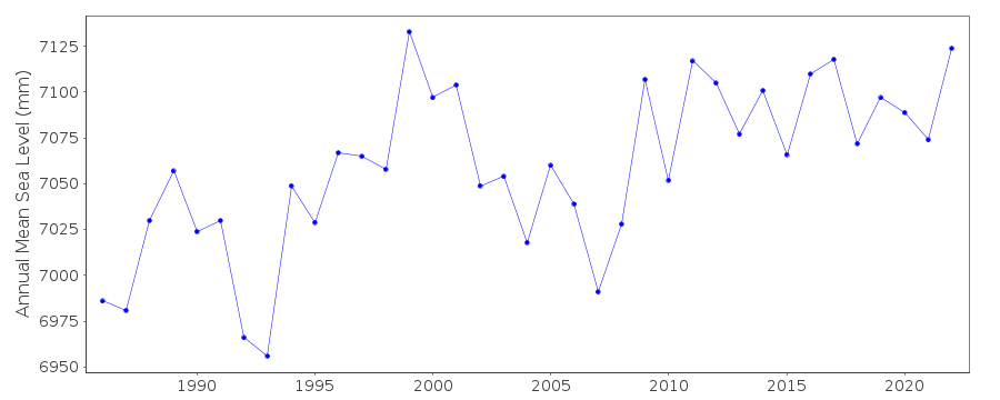 PSMSL Annual Mean Sea Level for '1693'  PSMSL Annual Mean Sea Level for '1891' 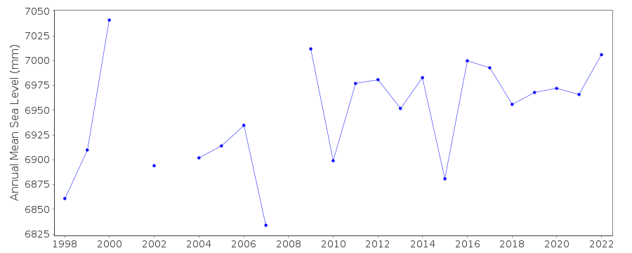 PSMSL Annual Mean Sea Level for '333' 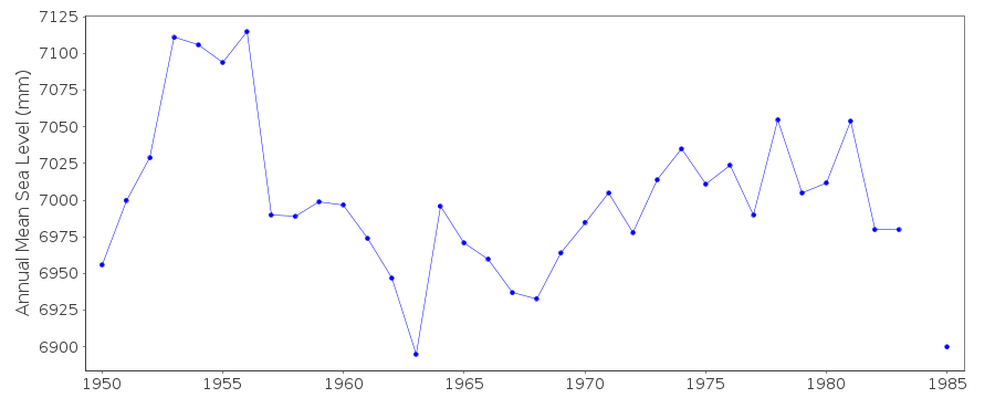 PSMSL Monthly Mean Sea Level for '333' 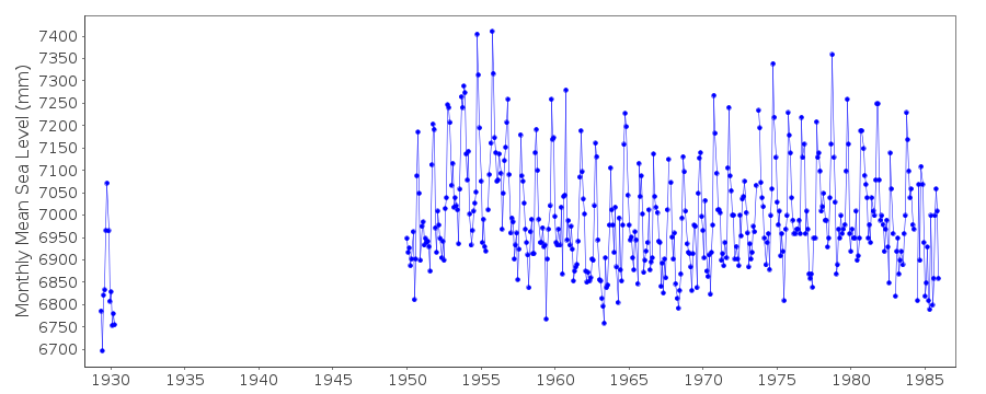
|
|
|