 |
SEALEVEL STATION CATALOG (SSC) |
|
|
|
|
|
| Station catalog metadata [edit] | [station overview] |
|---|
| SSC ID | SSC-pumo | | Station Name | Puerto Morelos | | Country | Mexico | | Latitude | 20.86813 | | Longitude | -86.86684 | | DateLastModified | 2021-12-10 17:05:38 |
| Linked codes |
|---|
| Codes | Location | Latitude | Longitude | Sensors | IOC: pumo | Puerto Morelos, Q. R. | 20.86813 | -86.86684 | flt |
IOC: pumo2 | Puerto Morelos | 20.86813 | -86.86684 | prs, rad, bat |
UHSLC: 860 | Puerto Moreles | 20.8683 | -86.8667 | N/A |
PTWC: pum2 | Puerto_Morelos_MX | 20.8681 | -86.8668 | flt, rad |
PTWC: pumo | Puerto_Morelos_MX | 20.8681 | -86.8668 | flt |
SONEL_GPS: 3265 | PUERTO MORELOS | 20.86850000 | -86.86820000 | N/A |
SONEL_GPS: 3544 | PUERTO MORELOS | 20.86811667 | -86.86685833 | N/A |
SONEL_TG: 3543 | PUERTO MORELOS | 20.86811700 | -86.86685800 | N/A |
| Distributed metadata source: IOC Sea Level Station Monitoring Facility pumo |
|---|
| Status | Operational |
| Local Contact | Universidad Nacional Autónoma de México ( Mexico ) |
| Other Contact | International Tsunami Information Center Caribbean Office ( USA ) |
| Connection | FTP box |
| Country | Mexico |
| Sensor 1 | |
| Type of sensor | flt |
| Sampling rate (min) | 1 |
| Distributed metadata source: IOC Sea Level Station Monitoring Facility pumo2 |
|---|
| GTS station code | 010F1446 |
| GTS message type | SOMX10 |
| Status | Operational |
| Local Contact | Universidad Nacional Autónoma de México ( Mexico ) |
| Other Contact | UNAVCO by EarthsScope ( USA ) |
| Other Contact | International Tsunami Information Center Caribbean Office ( USA ) |
| Connection | GTS message |
| Country | Mexico |
| Sensor 1 | |
| Type of sensor | prs |
| Sampling rate (min) | 1 |
| Sensor 2 | |
| Type of sensor | rad |
| Sampling rate (min) | 1 |
| Sensor 3 | |
| Type of sensor | bat |
| Sampling rate (min) | 5 |
| Distributed metadata source: PTWC COMP META file |
| DCP ID | 0101963A |
| WMO | SOMX10 |
| Samp Rate | 1 |
| Num# Samp | 10 |
| Unit | M |
| Scale | 1.0000 |
| Xmt Int. | 015 |
| Fst Min. | 0003 |
| HAR | 0 |
| Owner | UNAM |
| Distributed metadata source: UHSLC |
| UHSLC id | 860 |
| SSC id | pumo |
| UHSLC geojson | https://uhslc.soest.hawaii.edu/data/meta.geojson |
| Research quality data version a | 2007-10-22 - 2013-06-26 |
| RQ basin | atlantic |
IOC Sea Level Station Monitoring Facility - realtime graph for 'pumo' 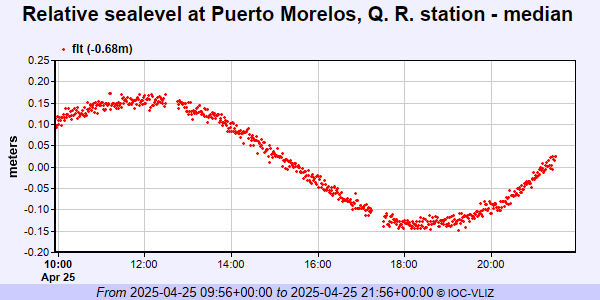 IOC Sea Level Station Monitoring Facility - realtime graph for 'pumo2' 
|
|
|