 |
SEALEVEL STATION CATALOG (SSC) |
|
|
|
|
|
| Station catalog metadata [edit] | [station overview] |
|---|
| SSC ID | SSC-ptro | | Station Name | Port Royal | | Country | Jamaica | | Latitude | 17.93333 | | Longitude | -76.85 | | DateLastModified | 2015-10-22 19:02:29 |
| Distributed metadata source: IOC Sea Level Station Monitoring Facility ptro |
|---|
| GTS station code | 92405008 |
| GTS message type | SOJM10 |
| Status | Down |
| Local Contact | Jamaican Meteorological Service ( Jamaica ) |
| Other Contact | UNAVCO by EarthsScope ( USA ) |
| Other Contact | International Tsunami Information Center Caribbean Office ( USA ) |
| Connection | GTS message |
| Country | Jamaica |
| Sensor 1 | |
| Type of sensor | prs |
| Sampling rate (min) | 1 |
| Sensor 2 | |
| Type of sensor | rad |
| Sampling rate (min) | 1 |
| Sensor 3 | |
| Type of sensor | bat |
| Sampling rate (min) | 5 |
| Distributed metadata source: GLOSS Station Handbook |
|---|
| Time Zone | 075W, GMT - 5hrs | | Ocean | Atlantic | | Operational | Yes | | Responsible country | Jamaica | | Other relevant codes | UHSLC 782 |
| Distributed metadata source: PTWC COMP META file |
| DCP ID | 92405008 |
| WMO | SOJM10 |
| Samp Rate | 1 |
| Num# Samp | 5 |
| Unit | m |
| Scale | 1.0000 |
| Xmt Int. | 005 |
| Fst Min. | 0001 |
| HAR | 0 |
| Owner | JMS |
| Distributed metadata source: UHSLC |
| UHSLC id | 782 |
| SSC id | ptro |
| GLOSS id | 210 |
| UHSLC geojson | https://uhslc.soest.hawaii.edu/data/meta.geojson |
| Research quality data version a | 1965-01-01 - 1971-12-31 |
| RQ basin | atlantic |
| Distributed metadata source: PSMSL |
| Name | KINGSTON |
| UHSLC ID | 782 |
| Is RLR | N |
| Has RLR Diagram | N link |
| QC Flag | N |
| Old ID | 932/001 |
| Last Updated | 2003-01-14 |
| Supplier | C.P.A.C.C. / M.A.C.C. |
| Address | Regional Archiving Centre, University of the West Indies, St. Augustine, TRINIDAD AND TOBAGO |
| Metric Start | 2001 |
| Metric End | 2001 |
| Metric Completeness | 16.7 |
| Download metric sea level data. | Use only with extreme caution. |
| Name | PORT ROYAL |
| GLOSS id | 210 |
| UHSLC ID | 782 |
| SONEL id | 3018 |
| Is RLR | Y |
| Has RLR Diagram | Y link |
| QC Flag | N |
| Old ID | 932/011 |
| Last Updated | null |
| Supplier | N.O.A.A. / N.O.S. |
| Address | N.O.A.A. / N.O.S., N/oes33, Ssmc4, Room 6531, 1305 East-West Highway, Silver Spring, , MD 20910, UNITED STATES |
| Metric Start | 1954 |
| Metric End | 1969 |
| Metric Completeness | 98.4 |
| RLR Start | 1954 |
| RLR End | 1969 |
| RLR Completeness | 98.4 |
| Download metric sea level data. | Use only with extreme caution. |
IOC Sea Level Station Monitoring Facility - realtime graph for 'ptro'  PSMSL Annual Mean Sea Level for '2003'  PSMSL Annual Mean Sea Level for '744' 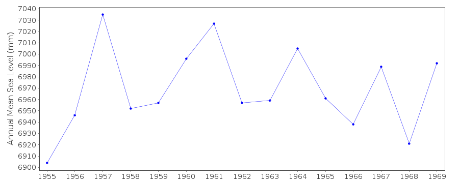 PSMSL Monthly Mean Sea Level for '744' 
|
|
|