 |
SEALEVEL STATION CATALOG (SSC) |
|
|
|
|
|
| Station catalog metadata [edit] | [station overview] |
|---|
| SSC ID | SSC-ptpl | | Station Name | Puerto Plata | | Country | Dominican Republic | | Latitude | 19.798794 | | Longitude | -70.702011 | | DateLastModified | 2015-10-22 19:02:29 |
| Linked codes |
|---|
| Codes | Location | Latitude | Longitude | Sensors | IOC: ptpl | Puerto Plata | 19.798794 | -70.702011 | prs, rad, ra2, bat, sw1, sw2 |
UHSLC: 777 | Puerto Plata | 19.79875 | -70.70205 | N/A |
PTWC: ppla | Puerto_Plata_DO | 19.7988 | -70.7020 | prs, ra2, rad |
PSMSL: 2343 | PUERTO PLATA B | 19.798000000000002 | -70.702 | N/A |
PSMSL: 577 | PUERTO PLATA | 19.816667 | -70.7 | N/A |
SONEL_GPS: 3556 | PUERTO PLATA | 19.75763056 | -70.56585000 | N/A |
SONEL_TG: 3555 | PUERTO PLATA | 19.81666700 | -70.70000000 | N/A |
| Distributed metadata source: IOC Sea Level Station Monitoring Facility ptpl |
|---|
| GTS station code | 301434061820970 |
| GTS message type | SZXX01 |
| Status | Operational |
| Local Contact | Oficina Nacional de Meteorología (Dominican Republic) |
| Other Contact | University of Hawaii Sea Level Center ( USA ) |
| Other Contact | Puerto Rico Seismic Network ( USA ) |
| Other Contact | International Tsunami Information Center Caribbean Office ( USA ) |
| Connection | GTS message |
| Country | Dominican Republic |
| Sensor 1 | |
| Type of sensor | prs |
| Sampling rate (min) | 1 |
| Sensor 2 | |
| Type of sensor | rad |
| Sampling rate (min) | 1 |
| Sensor 3 | |
| Type of sensor | ra2 |
| Sampling rate (min) | 1 |
| Sensor 4 | |
| Type of sensor | bat |
| Sampling rate (min) | 5 |
| Sensor 5 | |
| Type of sensor | sw1 |
| Sampling rate (min) | 60 |
| Sensor 6 | |
| Type of sensor | sw2 |
| Sampling rate (min) | 60 |
| Distributed metadata source: PTWC COMP META file |
| DCP ID | 301434061820970 |
| WMO | SZXX01 |
| Samp Rate | 1 |
| Num# Samp | 5 |
| Unit | M |
| Scale | 1.0000 |
| Xmt Int. | 005 |
| Fst Min. | 0001 |
| HAR | 1 |
| Owner | UHSLC |
| Distributed metadata source: UHSLC |
| UHSLC id | 777 |
| SSC id | ptpl |
| UHSLC geojson | https://uhslc.soest.hawaii.edu/data/meta.geojson |
| Research quality data version a | 2010-06-22 - 2017-09-04 |
| RQ basin | atlantic |
| Fast delivery | 2010-06-22 - 2026-06-30 |
| Distributed metadata source: PSMSL |
| Name | PUERTO PLATA B |
| UHSLC ID | 777 |
| Is RLR | Y |
| Has RLR Diagram | Y link |
| QC Flag | N |
| Old ID | 936/020 |
| Last Updated | 2023-03-07 |
| Supplier | UNIVERSITY OF HAWAII SEA LEVEL CENTER |
| Address | University of Hawaii Sea Level Center, Department of Oceanography Division of Natural Sciences, 1000 Pope Road, Honolulu, Hawaii 96822, UNITED STATES |
| Metric Start | 2010 |
| Metric End | 2017 |
| Metric Completeness | 89.6 |
| RLR Start | 2010 |
| RLR End | 2017 |
| RLR Completeness | 89.6 |
| Download metric sea level data. | Use only with extreme caution. |
| Name | PUERTO PLATA |
| UHSLC ID | 777 |
| SONEL id | 3556 |
| Is RLR | Y |
| Has RLR Diagram | Y link |
| QC Flag | Y |
| Old ID | 936/021 |
| Last Updated | null |
| Supplier | N.O.A.A. / N.O.S. |
| Address | N.O.A.A. / N.O.S., N/oes33, Ssmc4, Room 6531, 1305 East-West Highway, Silver Spring, , MD 20910, UNITED STATES |
| Metric Start | 1949 |
| Metric End | 1969 |
| Metric Completeness | 73.4 |
| RLR Start | 1949 |
| RLR End | 1969 |
| RLR Completeness | 73.4 |
| Download metric sea level data. | Use only with extreme caution. |
IOC Sea Level Station Monitoring Facility - realtime graph for 'ptpl' 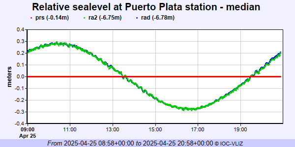 PSMSL Annual Mean Sea Level for '2343' 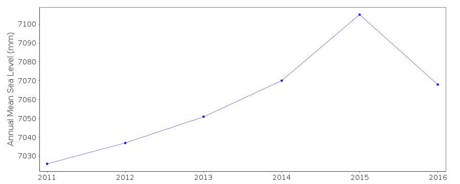 PSMSL Annual Mean Sea Level for '577'  PSMSL Monthly Mean Sea Level for '577' 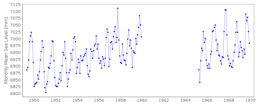
|
|
|