 |
SEALEVEL STATION CATALOG (SSC) |
|
|
|
|
|
| Station catalog metadata [edit] | [station overview] |
|---|
| SSC ID | SSC-ptlu | | Station Name | Port Louis | | Country | Mauritius | | Latitude | -20.15716 | | Longitude | 57.5043 | | DateLastModified | 2015-10-22 19:02:29 |
| Linked codes |
|---|
| Codes | Location | Latitude | Longitude | Sensors | IOC: ptlu | Pt.Louis | -20.15716 | 57.5043 | enc, prs, bat, sw1, sw2, rad |
GLOSS: 18 | Port Louis Harbour | -20.15 | 57.5 | Float |
UHSLC: 103 | Port Louis | -20.15721 | 57.50429 | N/A |
PTWC: ptlu | Port_luis_MU | -20.1572 | 57.5043 | prs, rad, enc |
PSMSL: 1673 | PORT LOUIS II | -20.15 | 57.5 | N/A |
PSMSL: 477 | PORT LOUIS | -20.15 | 57.5 | N/A |
SONEL_GPS: 2350 | PORT LOUIS | -20.29707590 | 57.49703615 | N/A |
SONEL_TG: 2351 | PORT LOUIS | -20.15725500 | 57.50429400 | N/A |
| Distributed metadata source: IOC Sea Level Station Monitoring Facility ptlu |
|---|
| GTS station code | 165B3038 |
| GTS message type | SXXX32 |
| Status | Operational |
| Local Contact | Mauritius Meteorological Services ( Mauritius ) |
| Other Contact | University of Hawaii Sea Level Center ( USA ) |
| Connection | GTS message |
| Country | Mauritius |
| Sensor 1 | |
| Type of sensor | prs |
| Sampling rate (min) | 1 |
| Sensor 2 | |
| Type of sensor | rad |
| Sampling rate (min) | 1 |
| Sensor 3 | |
| Type of sensor | enc |
| Sampling rate (min) | 6 |
| Sensor 4 | |
| Type of sensor | sw1 |
| Sampling rate (min) | 60 |
| Sensor 5 | |
| Type of sensor | sw2 |
| Sampling rate (min) | 60 |
| Sensor 6 | |
| Type of sensor | bat |
| Sampling rate (min) | 6 |
| Distributed metadata source: GLOSS Station Handbook |
|---|
| Time Zone | 060E, GMT + 4hrs | | Ocean | Indian | | Operational | Yes | | Responsible country | Mauritius | | Additional parameters | Mean Sea Level Pressure | | Tide gauge benchmarks | 1. 3m mark on tide staff
2. One brass bolt at edge of wharf of tide gauge
3. A bolt on the gauge
| | Benchmark relationships | 3m mark tied to the National Primary Levelling Network and Fundamental benchmark TTP30. The 3m mark is 1.6788m above Admiralty Chart Datum. The bolt on the gauge is 3.0488m above Admiralty Chart Datum. (February 1987 onwards) | | Auxiliary benchmarks | One bolt flush with wall located about 7.5m west of station. | | Other relevant information | Munro tide gauge in a stone building, corner of Quay D, dismantled in early 1970s. Zero of recorder corresponds to a marked level situated seven feet below the level of the Quay. This datum point denotes the level of the mean low water at spring tides and was selected in 1929 after taking the average of the low water spring tide levels over a 48 month period. Local levellings are undertaken at intervals of 6 months. | | Other relevant codes | UHSLC 103 | | Nearest Met. station | Meteorological station, Vacoas |
| Distributed metadata source: PTWC COMP META file |
| DCP ID | 165B3038 |
| WMO | SXXX32 |
| Samp Rate | 6 |
| Num# Samp | 10 |
| Unit | M |
| Scale | 1.0000 |
| Xmt Int. | 006 |
| Fst Min. | 0001 |
| HAR | 1 |
| Owner | UHSLC |
| Distributed metadata source: UHSLC |
| UHSLC id | 103 |
| SSC id | ptlu |
| GLOSS id | 18 |
| UHSLC geojson | https://uhslc.soest.hawaii.edu/data/meta.geojson |
| Research quality data version a | 1942-01-01 - 1947-12-31 |
| Research quality data version b | 1964-03-01 - 1965-12-31 |
| Research quality data version c | 1986-08-01 - 2023-11-09 |
| RQ basin | indian |
| Fast delivery | 1986-08-01 - 2026-05-31 |
| Distributed metadata source: PSMSL |
| Name | PORT LOUIS II |
| GLOSS id | 18 |
| UHSLC ID | 103 |
| SONEL id | 2350 |
| Is RLR | Y |
| Has RLR Diagram | Y link |
| QC Flag | N |
| Old ID | 450/012 |
| Last Updated | 2026-01-23 |
| Supplier | METEOROLOGICAL SERVICES, MAURITIUS |
| Address | Meteorological Services, Meteorological Services Headquarters, St. Paul Road, Vacoas, MAURITIUS |
| Metric Start | 1986 |
| Metric End | 2025 |
| Metric Completeness | 96.9 |
| RLR Start | 1986 |
| RLR End | 2025 |
| RLR Completeness | 96.9 |
| Download metric sea level data. | Use only with extreme caution. |
| Name | PORT LOUIS |
| GLOSS id | 18 |
| UHSLC ID | 103 |
| Is RLR | Y |
| Has RLR Diagram | Y link |
| QC Flag | N |
| Old ID | 450/011 |
| Last Updated | 1991-06-12 |
| Supplier | METEOROLOGICAL SERVICES, MAURITIUS |
| Address | Meteorological Services, Meteorological Services Headquarters, St. Paul Road, Vacoas, MAURITIUS |
| Metric Start | 1942 |
| Metric End | 1965 |
| Metric Completeness | 75.7 |
| RLR Start | 1942 |
| RLR End | 1965 |
| RLR Completeness | 75.7 |
| Download metric sea level data. | Use only with extreme caution. |
IOC Sea Level Station Monitoring Facility - realtime graph for 'ptlu' 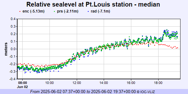 PSMSL Annual Mean Sea Level for '1673' 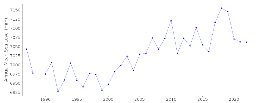 PSMSL Annual Mean Sea Level for '477' 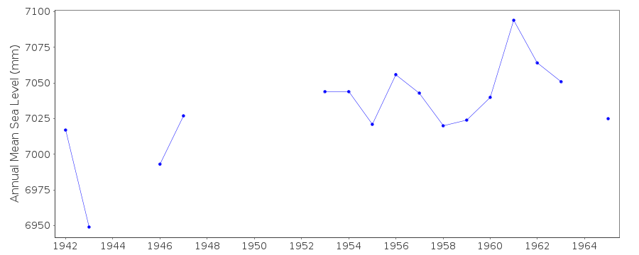 PSMSL Monthly Mean Sea Level for '477' 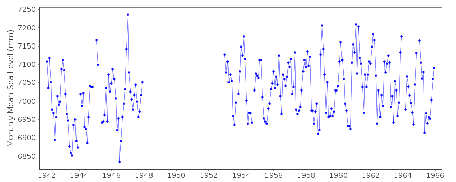
|
|
|