 |
SEALEVEL STATION CATALOG (SSC) |
|
|
|
|
|
| Station catalog metadata [edit] | [station overview] |
|---|
| SSC ID | SSC-ptga | | Station Name | Point Galeota | | Country | Trinidad and Tobago | | Latitude | 10.1380556 | | Longitude | -60.9919444 | | DateLastModified | 2015-10-22 19:02:29 |
| Linked codes |
|---|
| Codes | Location | Latitude | Longitude | Sensors | IOC: gale | Galeota | 10.1387333 | -61.00195 | rad |
IOC: ptga | Point Galeota | 10.1380556 | -60.9919444 | rad |
PTWC: ptga | | | | |
PSMSL: 2008 | GUAYAGUAYARE | 10.133333 | -61.0 | N/A |
| Distributed metadata source: IOC Sea Level Station Monitoring Facility gale |
|---|
| GTS station code | A9C013C0 |
| GTS message type | SOTD10 |
| Status | Operational |
| Local Contact | Land and Surveys Division, Hydrographic Unit ( Trinidad and Tobago ) |
| Other Contact | Caribbean Community Climate Change Centre ( Trinidad and Tobago ) |
| Other Contact | International Tsunami Information Center Caribbean Office ( USA ) |
| Connection | GTS message |
| Country | Trinidad & Tobago |
| Sensor 1 | |
| Type of sensor | rad |
| Sampling rate (min) | 10 |
| Distributed metadata source: IOC Sea Level Station Monitoring Facility ptga |
|---|
| Status | Down |
| Local Contact | Land and Surveys Division, Hydrographic Unit ( Trinidad and Tobago ) |
| Other Contact | Caribbean Community Climate Change Centre ( Trinidad and Tobago ) |
| Connection | GTS message |
| Country | Trinidad & Tobago |
| Sensor 1 | |
| Type of sensor | rad |
| Sampling rate (min) | 10 |
| Distributed metadata source: PTWC COMP META file |
| DCP ID | |
| WMO | |
| Samp Rate | |
| Num# Samp | |
| Unit | |
| Scale | |
| Xmt Int. | |
| Fst Min. | |
| HAR | |
| Owner | |
| Distributed metadata source: PSMSL |
| Name | GUAYAGUAYARE |
| Is RLR | N |
| Has RLR Diagram | N link |
| QC Flag | N |
| Old ID | 890/031 |
| Last Updated | 2003-01-14 |
| Supplier | C.P.A.C.C. / M.A.C.C. |
| Address | Regional Archiving Centre, University of the West Indies, St. Augustine, TRINIDAD AND TOBAGO |
| Metric Start | 2001 |
| Metric End | 2001 |
| Metric Completeness | 41.7 |
| Download metric sea level data. | Use only with extreme caution. |
IOC Sea Level Station Monitoring Facility - realtime graph for 'gale' 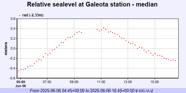 IOC Sea Level Station Monitoring Facility - realtime graph for 'ptga'  PSMSL Annual Mean Sea Level for '2008'  PSMSL Monthly Mean Sea Level for '2008' 
|
|
|