 |
SEALEVEL STATION CATALOG (SSC) |
|
|
|
|
|
| Station catalog metadata [edit] | [station overview] |
|---|
| SSC ID | SSC-ptbl | | Station Name | Port Blair | | Country | India | | Latitude | 11.68333 | | Longitude | 92.76666 | | DateLastModified | 2015-10-22 19:02:29 |
| Distributed metadata source: IOC Sea Level Station Monitoring Facility ptbl |
|---|
| GTS station code | 43332 |
| GTS message type | SZZZ34 |
| Status | Operational |
| Local Contact | Indian National Centre for Ocean Information Services ( India ) |
| Connection | FTP box |
| Country | India |
| Sensor 1 | |
| Type of sensor | prs |
| Sampling rate (min) | 1 |
| Distributed metadata source: GLOSS Station Handbook |
|---|
| Ocean | Indian | | Operational | No | | Responsible country | India | | Data acquisition rate | Continuous recording | | Tide gauge benchmarks | BMIE GTS situated behind the Transport Office of the Marine Department | | Benchmark relationships | 5.30m above chart datum (1952) | | Other relevant information | GPS and real time data available |
| Distributed metadata source: PTWC COMP META file |
| DCP ID | 1234AAAB |
| WMO | FTPI00 |
| Samp Rate | 1 |
| Num# Samp | 10 |
| Unit | m |
| Scale | 1.0000 |
| Xmt Int. | 010 |
| Fst Min. | 0000 |
| HAR | 0 |
| Owner | INCO |
| Distributed metadata source: UHSLC |
| UHSLC id | 908 |
| SSC id | ptbl |
| GLOSS id | 38 |
| UHSLC geojson | https://uhslc.soest.hawaii.edu/data/meta.geojson |
| Fast delivery | 2022-11-01 - 2026-05-31 |
| Distributed metadata source: PSMSL |
| Name | PORT BLAIR |
| GLOSS id | 38 |
| UHSLC ID | 908 |
| SONEL id | 2070 |
| Is RLR | Y |
| Has RLR Diagram | Y link |
| QC Flag | N |
| Old ID | 540/001 |
| Last Updated | 2026-06-09 |
| Supplier | SURVEY OF INDIA |
| Address | Survey of India, Geodetic and Research Branch, 17 E.C. Road, Dehra Dun , PIN 248 001, INDIA |
| Metric Start | 1916 |
| Metric End | 2025 |
| Metric Completeness | 23.6 |
| RLR Start | 1916 |
| RLR End | 1964 |
| RLR Completeness | 28.7 |
| Download metric sea level data. | Use only with extreme caution. |
IOC Sea Level Station Monitoring Facility - realtime graph for 'ptbl' 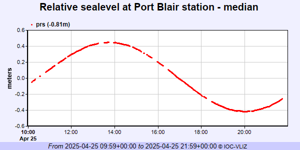 PSMSL Annual Mean Sea Level for '206' 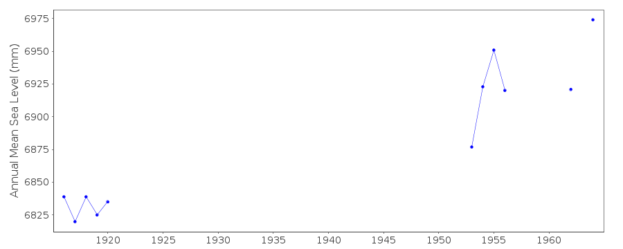 PSMSL Monthly Mean Sea Level for '206' 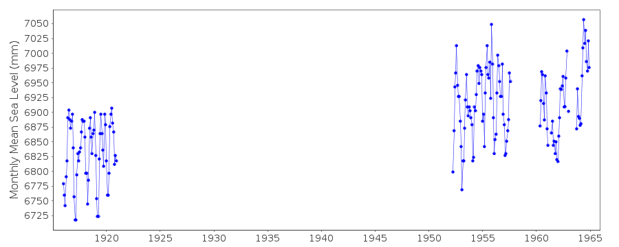
|
|
|