 |
SEALEVEL STATION CATALOG (SSC) |
|
|
|
|
|
| Station catalog metadata [edit] | [station overview] |
|---|
| SSC ID | SSC-prud | | Station Name | Prudhoe Bay, Alaska | | Country | United States | | Latitude | 70.388 | | Longitude | -148.51 | | DateLastModified | 2015-10-22 19:02:29 |
| Distributed metadata source: IOC Sea Level Station Monitoring Facility prud |
|---|
| Status | Operational |
| Local Contact | National Ocean Service-NOAA ( USA ) |
| Connection | WEB service |
| Country | USA |
| Sensor 1 | |
| Type of sensor | wls |
| Sampling rate (min) | 1 |
| Distributed metadata source: IOC Sea Level Station Monitoring Facility prud2 |
|---|
| GTS station code | 33A4A9FE |
| GTS message type | SXXX03 |
| Status | Operational |
| Local Contact | National Ocean Service-NOAA ( USA ) |
| Connection | GTS message |
| Country | USA |
| Sensor 1 | |
| Type of sensor | pwl |
| Sampling rate (min) | 1 |
| Distributed metadata source: GLOSS Station Handbook |
|---|
| Time Zone | 135W, GMT - 9hrs | | Ocean | Arctic | | Operational | Yes | | Data acquisition rate | 6 minute intervals | | Additional parameters | Air/sea temperature, barometric pressure, wind sensors | | Tide gauge benchmarks | The benchmark is the high point on top of the sheet pile bulkhead where two pieces seam together on West Dock #2. Benchmark is designated 'unstamped 2'. | | Benchmark relationships | TGBM = 7.68 feet above mean lower low water (154 HW/155 LW 1980-1981)
TGBM = 7.33 feet above mean sea level (154 HW/155 LW 1980-1981)
TGBM = 7.08 feet above mean high water (154 HW/155 LW 1980-1981) | | Auxiliary benchmarks | Movement seen between 'steel pin' and 'state 1' and cell 6B and digibulb stop. BM Bridge installed 1993. | | Other relevant information | Using acoustic in the ice free season and a bubbler gauge when there is ice while the gauge is rebuilt. 1976-1989 data collected during ice-free months only (usually July, August and September) | | Other relevant codes | UHSLC 579A |
| Distributed metadata source: PTWC COMP META file |
| DCP ID | 33A4A9FE |
| WMO | SXXX20 |
| Samp Rate | 6 |
| Num# Samp | 1 |
| Unit | M |
| Scale | 1.0000 |
| Xmt Int. | 006 |
| Fst Min. | 0002 |
| HAR | 0 |
| Owner | NOS |
| Distributed metadata source: UHSLC |
| UHSLC id | 579 |
| SSC id | prud |
| GLOSS id | 151 |
| UHSLC geojson | https://uhslc.soest.hawaii.edu/data/meta.geojson |
| Research quality data version a | 1989-05-01 - 2022-12-31 |
| RQ basin | pacific |
| Fast delivery | 1989-05-01 - 2026-05-31 |
| Distributed metadata source: PSMSL |
| Name | PRUDHOE BAY, ALASKA |
| GLOSS id | 151 |
| UHSLC ID | 579 |
| SONEL id | 2677 |
| Is RLR | Y |
| Has RLR Diagram | Y link |
| QC Flag | N |
| Old ID | 821/002 |
| Last Updated | 2026-01-28 |
| Supplier | N.O.A.A. / N.O.S. |
| Address | N.O.A.A. / N.O.S., N/oes33, Ssmc4, Room 6531, 1305 East-West Highway, Silver Spring, , MD 20910, UNITED STATES |
| Metric Start | 1994 |
| Metric End | 2025 |
| Metric Completeness | 96.1 |
| RLR Start | 1994 |
| RLR End | 2025 |
| RLR Completeness | 96.1 |
| Download metric sea level data. | Use only with extreme caution. |
IOC Sea Level Station Monitoring Facility - realtime graph for 'prud' 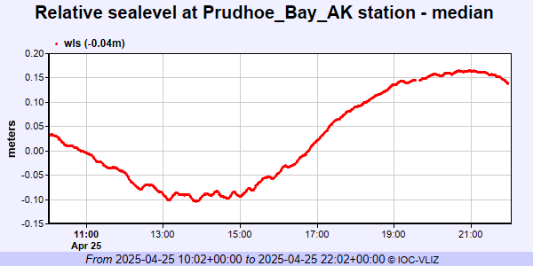 IOC Sea Level Station Monitoring Facility - realtime graph for 'prud2' 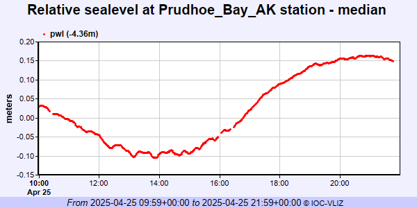 PSMSL Annual Mean Sea Level for '1857' 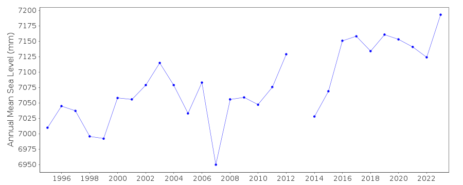 PSMSL Monthly Mean Sea Level for '1857' 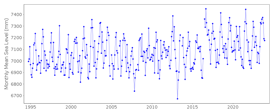
|
|
|