 |
SEALEVEL STATION CATALOG (SSC) |
|
|
|
|
|
| Station catalog metadata [edit] | [station overview] |
|---|
| SSC ID | SSC-prog | | Station Name | Progreso | | Country | Mexico | | Latitude | 21.3 | | Longitude | -89.65 | | DateLastModified | 2015-10-22 19:02:29 |
| Distributed metadata source: IOC Sea Level Station Monitoring Facility prog |
|---|
| Status | Operational |
| Local Contact | Universidad Nacional Autónoma de México ( Mexico ) |
| Connection | FTP box |
| Country | Mexico |
| Sensor 1 | |
| Type of sensor | rad |
| Sampling rate (min) | 1 |
| Distributed metadata source: IOC Sea Level Station Monitoring Facility prog2 |
|---|
| GTS station code | 01029134 |
| GTS message type | SOMX10 |
| Status | Operational |
| Local Contact | Universidad Nacional Autónoma de México ( Mexico ) |
| Other Contact | International Tsunami Information Center Caribbean Office ( USA ) |
| Connection | GTS message |
| Country | Mexico |
| Sensor 1 | |
| Type of sensor | rad |
| Sampling rate (min) | 1 |
| Sensor 2 | |
| Type of sensor | bat |
| Sampling rate (min) | 15 |
| Distributed metadata source: GLOSS Station Handbook |
|---|
| Time Zone | 090W, GMT - 6hrs | | Ocean | Atlantic | | Operational | No | | Responsible country | Mexico | | Additional parameters | Sea temperature, sea density | | Auxiliary benchmarks | Aux#1: It is near south edge of western half of pier, 0.54ft from north east edge of iron bollard, 4.4ft north of south edge of pier.
Aux#2: It is 0.33ft west of west of face of concrete curb and 0.4ft south edge, between lamp post #34 and #35.
|
| Distributed metadata source: PTWC COMP META file |
| DCP ID | 01029134 |
| WMO | SOMX10 |
| Samp Rate | 1 |
| Num# Samp | 15 |
| Unit | M |
| Scale | 1.0000 |
| Xmt Int. | 015 |
| Fst Min. | 0014 |
| HAR | 1 |
| Owner | UNAM |
| Distributed metadata source: UHSLC |
| UHSLC id | 721 |
| SSC id | prog |
| GLOSS id | 213 |
| UHSLC geojson | https://uhslc.soest.hawaii.edu/data/meta.geojson |
| Research quality data version a | 1980-01-01 - 1984-12-31 |
| Research quality data version b | 1999-06-03 - 2004-12-19 |
| Research quality data version c | 2012-05-16 - 2013-06-05 |
| RQ basin | atlantic |
| Distributed metadata source: PSMSL |
| Name | PROGRESO |
| GLOSS id | 213 |
| UHSLC ID | 721 |
| SONEL id | 2954 |
| Is RLR | Y |
| Has RLR Diagram | Y link |
| QC Flag | N |
| Old ID | 920/001 |
| Last Updated | 2015-06-24 |
| Supplier | SERVICIO MAREOGRAFICO NACIONAL, MEXICO |
| Address | Servicio Mareografico Nacional, Instituto de Geofisica, Ciudad Universitaria, Delegacion de Coyoacan, 04510 Mexico D.F., MEXICO |
| Metric Start | 1952 |
| Metric End | 2013 |
| Metric Completeness | 53.8 |
| RLR Start | 1952 |
| RLR End | 2013 |
| RLR Completeness | 53.8 |
| Download metric sea level data. | Use only with extreme caution. |
IOC Sea Level Station Monitoring Facility - realtime graph for 'prog' 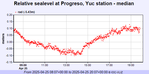 IOC Sea Level Station Monitoring Facility - realtime graph for 'prog2' 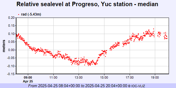 PSMSL Annual Mean Sea Level for '690'  PSMSL Monthly Mean Sea Level for '690' 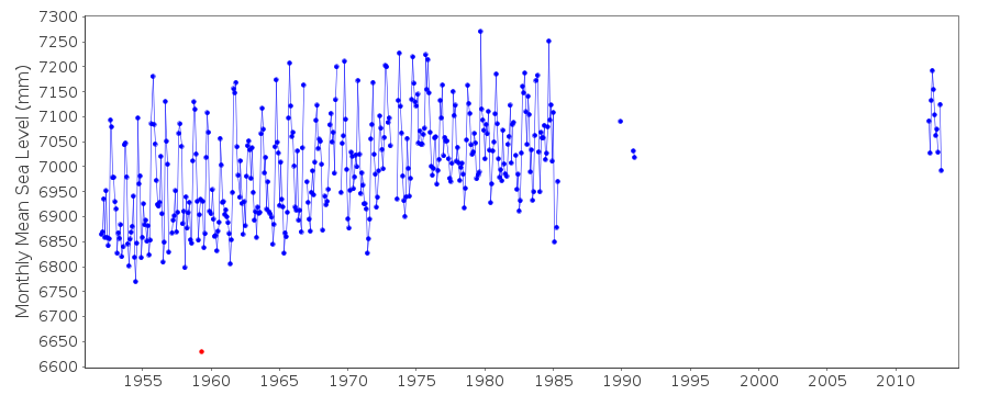
|
|
|