 |
SEALEVEL STATION CATALOG (SSC) |
|
|
|
|
|
| Station catalog metadata [edit] | [station overview] |
|---|
| SSC ID | SSC-pors | | Station Name | Port Stanvac | | Country | Australia | | Latitude | -35.1086 | | Longitude | 138.467 | | DateLastModified | 2015-10-22 19:02:29 |
| Distributed metadata source: IOC Sea Level Station Monitoring Facility pors |
|---|
| GTS station code | 61583 |
| GTS message type | SZAU01 |
| Status | Down |
| Local Contact | National Tidal Centre/Australian Bureau of Meteorology ( Australia ) |
| Connection | GTS message |
| Country | Australia |
| Sensor 1 | |
| Type of sensor | prs |
| Sampling rate (min) | 1 |
| Distributed metadata source: PTWC COMP META file |
| DCP ID | |
| WMO | |
| Samp Rate | |
| Num# Samp | |
| Unit | |
| Scale | |
| Xmt Int. | |
| Fst Min. | |
| HAR | |
| Owner | |
| Distributed metadata source: UHSLC |
| UHSLC id | 100 |
| SSC id | pors |
| UHSLC geojson | https://uhslc.soest.hawaii.edu/data/meta.geojson |
| Research quality data version a | 1992-06-23 - 2010-11-30 |
| RQ basin | indian |
| Distributed metadata source: PSMSL |
| Name | PORT STANVAC |
| UHSLC ID | 100 |
| SONEL id | 2978 |
| Is RLR | Y |
| Has RLR Diagram | Y link |
| QC Flag | N |
| Old ID | 680/298 |
| Last Updated | 2011-10-13 |
| Supplier | NATIONAL TIDAL CENTRE |
| Address | National Tidal Centre, Bureau of Meteorology, PO Box 421, Kent Town 5071, South Australia, AUSTRALIA |
| Metric Start | 1980 |
| Metric End | 2010 |
| Metric Completeness | 59.7 |
| RLR Start | 1993 |
| RLR End | 2010 |
| RLR Completeness | 99.5 |
| Download metric sea level data. | Use only with extreme caution. |
IOC Sea Level Station Monitoring Facility - realtime graph for 'pors'  PSMSL Annual Mean Sea Level for '1506'  PSMSL Monthly Mean Sea Level for '1506' 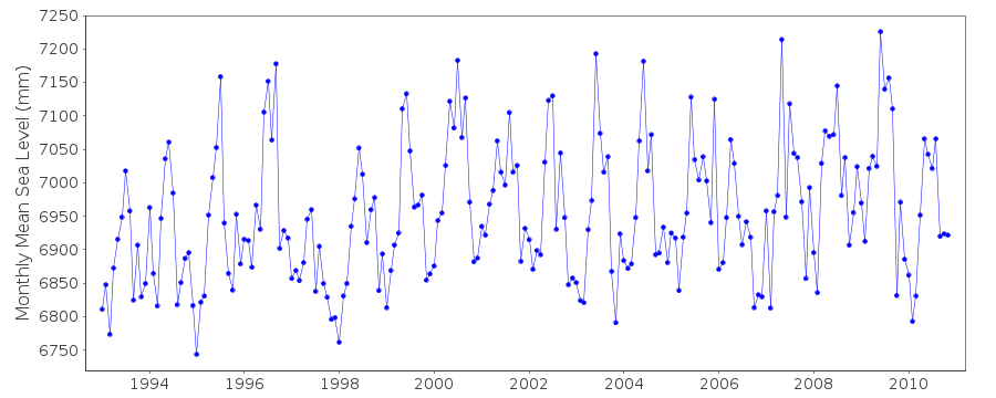
|
|
|