 |
SEALEVEL STATION CATALOG (SSC) |
|
|
|
|
|
| Station catalog metadata [edit] | [station overview] |
|---|
| SSC ID | SSC-poam | | Station Name | Ponta da Madeira | | Country | Brazil | | Latitude | -2.56666 | | Longitude | -44.36666 | | DateLastModified | 2015-10-22 19:02:29 |
| Distributed metadata source: GLOSS Station Handbook |
|---|
| Time Zone | 045W, GMT - 3hrs | | Ocean | Atlantic | | Operational | Yes | | Responsible country | Brazil | | Data acquisition rate | Hourly | | Tide gauge benchmarks | RN-P(CVRD) - bronze mark at a small pilar, near the tide gauge on the right. It has the no. 91374 printed in red colour. | | Benchmark relationships | Tide Gauge Zero (TGZ) = chart datum
TGZ = 913.7cm below TGBM
TGZ = 343.0cm below mean sea level
| | Auxiliary benchmarks | BM-3 (CVRD) - set on a concrete box between the railway and the road, near the mineral patio. | | Nearest Met. station | 00101 - Ponta da Madeira |
| Distributed metadata source: UHSLC |
| UHSLC id | 715 |
| SSC id | poam |
| GLOSS id | 200 |
| UHSLC geojson | https://uhslc.soest.hawaii.edu/data/meta.geojson |
| Research quality data version a | 1988-01-01 - 2009-02-01 |
| RQ basin | atlantic |
| Distributed metadata source: PSMSL |
| Name | MADEIRA |
| GLOSS id | 200 |
| UHSLC ID | 715 |
| Is RLR | Y |
| Has RLR Diagram | Y link |
| QC Flag | N |
| Old ID | 874/155 |
| Last Updated | 2017-11-14 |
| Supplier | DIRECTOR OF HYDROGRAPHY AND NAVIGATION (DHN) |
| Address | Director of Hydrography and Naviagation, Rua Barao de Jaceguai, , S/No - Ponta da Armacao, BRAZIL |
| Metric Start | 1988 |
| Metric End | 2008 |
| Metric Completeness | 74.6 |
| RLR Start | 1988 |
| RLR End | 2008 |
| RLR Completeness | 74.6 |
| Download metric sea level data. | Use only with extreme caution. |
PSMSL Annual Mean Sea Level for '1736' 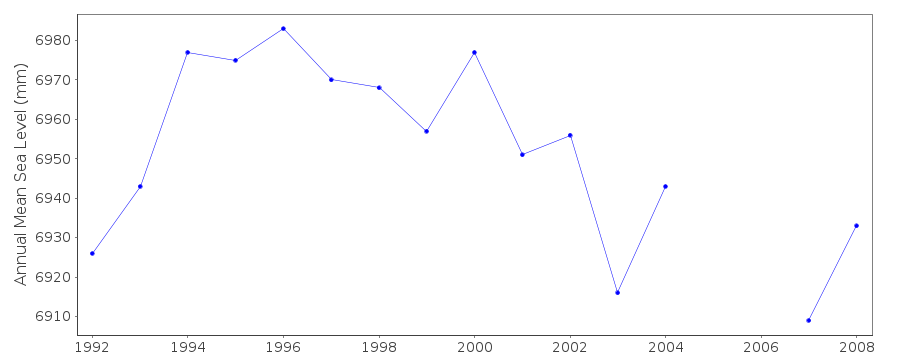 PSMSL Monthly Mean Sea Level for '1736' 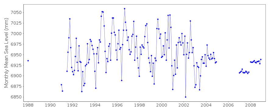
|
|
|