 |
SEALEVEL STATION CATALOG (SSC) |
|
|
|
|
|
| Station catalog metadata [edit] | [station overview] |
|---|
| SSC ID | SSC-pine | | Station Name | Piney Point | | Country | United States | | Latitude | 38.133333 | | Longitude | -76.533333 | | DateLastModified | 2015-10-22 19:02:29 |
| Linked codes |
|---|
| Codes | Location | Latitude | Longitude | Sensors | PSMSL: 971 | PINEY POINT, MARYLAND | 38.133333 | -76.533333 | N/A |
| Distributed metadata source: PSMSL |
| Name | PINEY POINT, MARYLAND |
| Is RLR | Y |
| Has RLR Diagram | Y link |
| QC Flag | N |
| Old ID | 960/077 |
| Last Updated | null |
| Supplier | N.O.A.A. / N.O.S. |
| Address | N.O.A.A. / N.O.S., N/oes33, Ssmc4, Room 6531, 1305 East-West Highway, Silver Spring, , MD 20910, UNITED STATES |
| Metric Start | 1960 |
| Metric End | 1973 |
| Metric Completeness | 77.4 |
| RLR Start | 1960 |
| RLR End | 1973 |
| RLR Completeness | 77.4 |
| Download metric sea level data. | Use only with extreme caution. |
PSMSL Annual Mean Sea Level for '971' 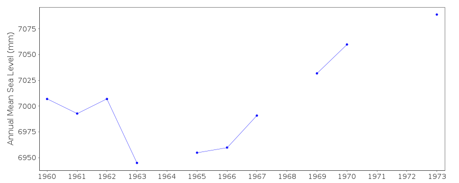 PSMSL Monthly Mean Sea Level for '971' 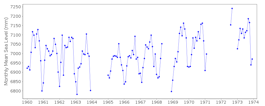
|
|
|