 |
SEALEVEL STATION CATALOG (SSC) |
|
|
|
|
|
| Station catalog metadata [edit] | [station overview] |
|---|
| SSC ID | SSC-penr | | Station Name | Penrhyn | | Country | Cook Islands | | Latitude | -9.001 | | Longitude | -158.051 | | DateLastModified | 2015-10-22 19:02:29 |
| Linked codes |
|---|
| Codes | Location | Latitude | Longitude | Sensors | IOC: penr | Penrhyn_CK | -9.001 | -158.051 | prs, rad, ra2, ra3, bat, sw1, sw2 |
GLOSS: 143 | Penrhyn | -8.59 | -158.06666 | Float |
UHSLC: 24 | Penrhyn | -8.97692 | -158.05303 | N/A |
PTWC: penr | Penrhyn_CK | -9.0010 | -158.0510 | prs, ra2, ra3, rad |
PSMSL: 1450 | PENRHYN | -9.016667 | -158.066667 | N/A |
SONEL_TG: 2846 | PENRHYN | -9.00100000 | -158.05100000 | N/A |
| Distributed metadata source: IOC Sea Level Station Monitoring Facility penr |
|---|
| GTS station code | 300434068595910 |
| GTS message type | SZXX01 |
| Status | Operational |
| Other Contact | University of Hawaii Sea Level Center ( USA ) |
| Connection | GTS message |
| Country | Cook Islands |
| Sensor 1 | |
| Type of sensor | prs |
| Sampling rate (min) | 1 |
| Sensor 2 | |
| Type of sensor | rad |
| Sampling rate (min) | 1 |
| Sensor 3 | |
| Type of sensor | ra2 |
| Sampling rate (min) | 1 |
| Sensor 4 | |
| Type of sensor | ra3 |
| Sampling rate (min) | 1 |
| Sensor 5 | |
| Type of sensor | bat |
| Sampling rate (min) | 5 |
| Sensor 6 | |
| Type of sensor | sw1 |
| Sampling rate (min) | 60 |
| Sensor 7 | |
| Type of sensor | sw2 |
| Sampling rate (min) | 60 |
| Distributed metadata source: GLOSS Station Handbook |
|---|
| Time Zone | 150W, GMT - 10hrs | | Ocean | Pacific | | Operational | Yes | | Tide gauge benchmarks | BM2: SS disc, no markings, at base of radio tower, 72.5ft west of BM1. | | Auxiliary benchmarks | BM3: SS disc, 'BM3' in concrete, 12ft west of tide staff along quay, 2 inches below surface elevation, concrete block 12x12 inches, 2ft from edge of quay. Likely to be covered by loose sand and rocks.
BM1: SS disk marked 'BM 1 1977' in concrete 3ft N of tide well set in base of tide station; in cement supporting Handar antenna. Destroyed Sept 1989.
Concrete slab broken later repaired - level has changed.
| | Other relevant information | Backup gauge on site: Handar Encoder (July 1986 - onwards).
Daily values calculated using 119-point convolution filter (Bloomfield, 1976) centred on noon applied to the hourly data with respective periods of the 95, 50 and 5% amplitude points at 124.0, 60.2 and 40.2 hours.
| | Other relevant codes | UHSLC 024 |
| Distributed metadata source: PTWC COMP META file |
| DCP ID | 300434068595910 |
| WMO | SZXX01 |
| Samp Rate | 1 |
| Num# Samp | 1 |
| Unit | M |
| Scale | 1.0000 |
| Xmt Int. | 005 |
| Fst Min. | 0001 |
| HAR | 1 |
| Owner | UHSLC |
| Distributed metadata source: UHSLC |
| UHSLC id | 024 |
| SSC id | penr |
| GLOSS id | 143 |
| UHSLC geojson | https://uhslc.soest.hawaii.edu/data/meta.geojson |
| Research quality data version a | 1977-04-16 - 2024-12-31 |
| RQ basin | pacific |
| Fast delivery | 1977-04-16 - 2026-05-31 |
| Distributed metadata source: PSMSL |
| Name | PENRHYN |
| GLOSS id | 143 |
| UHSLC ID | 24 |
| Is RLR | Y |
| Has RLR Diagram | Y link |
| QC Flag | N |
| Old ID | 775/001 |
| Last Updated | 2020-01-28 |
| Supplier | UNIVERSITY OF HAWAII SEA LEVEL CENTER |
| Address | University of Hawaii Sea Level Center, Department of Oceanography Division of Natural Sciences, 1000 Pope Road, Honolulu, Hawaii 96822, UNITED STATES |
| Metric Start | 1977 |
| Metric End | 2018 |
| Metric Completeness | 95.4 |
| RLR Start | 1977 |
| RLR End | 2018 |
| RLR Completeness | 95.4 |
| Download metric sea level data. | Use only with extreme caution. |
IOC Sea Level Station Monitoring Facility - realtime graph for 'penr' 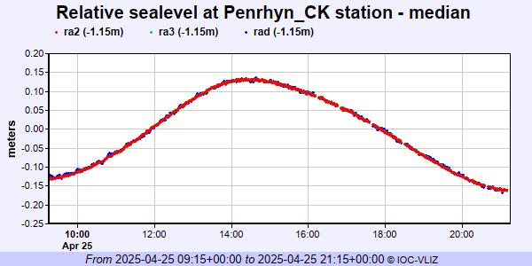 PSMSL Annual Mean Sea Level for '1450'  PSMSL Monthly Mean Sea Level for '1450' 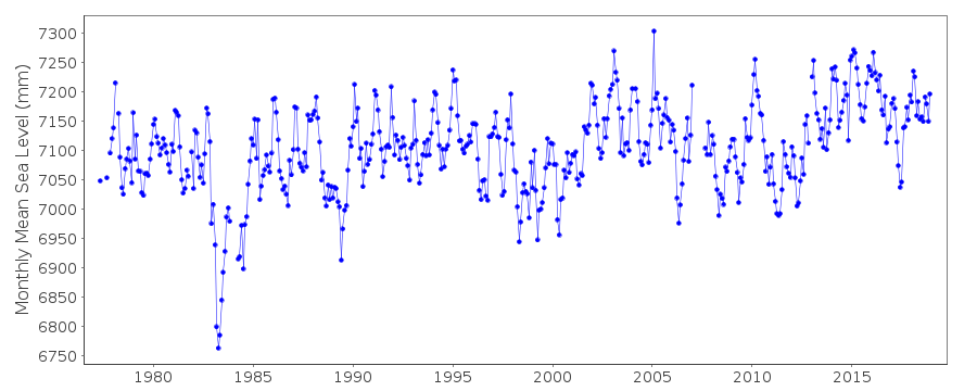
|
|
|