 |
SEALEVEL STATION CATALOG (SSC) |
|
|
|
|
|
| Station catalog metadata [edit] | [station overview] |
|---|
| SSC ID | SSC-pdas | | Station Name | Ponta Delgada | | Country | Portugal | | Latitude | 37.73 | | Longitude | -25.68 | | DateLastModified | 2015-10-22 19:02:29 |
| Linked codes |
|---|
| Codes | Location | Latitude | Longitude | Sensors | IOC: pdas | Ponta_Delgada_Azor | 37.73 | -25.68 | prs, rad, ra2, bat, sw1, sw2 |
GLOSS: 245 | Ponta Delgado, Azores | 37.4416 | -25.4027 | Float, Acoustic |
UHSLC: 211 | Ponta Delgada | 37.7356 | -25.6714 | N/A |
PTWC: pdas | Ponta_Delgada_PT | 37.7357 | -25.6714 | prs, rad, ra2 |
PSMSL: 1885 | PONTA DELGADA 2 | 37.733333 | -25.666667 | N/A |
PSMSL: 258 | PONTA DELGADA | 37.735583 | -25.671408 | N/A |
SONEL_GPS: 811 | PONTA DELGADA | 37.74769974 | -25.66279984 | N/A |
SONEL_TG: 1982 | PONTA DELGADA | 37.73329926 | -25.66670036 | N/A |
| Distributed metadata source: IOC Sea Level Station Monitoring Facility pdas |
|---|
| GTS station code | 354271CC |
| GTS message type | SEPO40 |
| Status | Operational |
| Local Contact | Instituto Hidrográfico ( Portugal ) |
| Other Contact | University of Hawaii Sea Level Center ( USA ) |
| Connection | GTS message |
| Country | Portugal |
| Sensor 1 | |
| Type of sensor | prs |
| Sampling rate (min) | 1 |
| Sensor 2 | |
| Type of sensor | rad |
| Sampling rate (min) | 1 |
| Sensor 3 | |
| Type of sensor | ra2 |
| Sampling rate (min) | 5 |
| Sensor 4 | |
| Type of sensor | sw1 |
| Sampling rate (min) | 60 |
| Sensor 5 | |
| Type of sensor | sw2 |
| Sampling rate (min) | 60 |
| Sensor 6 | |
| Type of sensor | bat |
| Sampling rate (min) | 5 |
| Distributed metadata source: GLOSS Station Handbook |
|---|
| Time Zone | 015W, GMT - 1hr | | Ocean | Atlantic | | Operational | Yes | | Responsible country | Portugal | | Data acquisition rate | Continuous analogue record | | Tide gauge benchmarks | NP - benchmark bolt at the root of pier | | Benchmark relationships | Tide gauge zero (TGZ) = Portuguese Hydrographic Institute Chart Datum
TGZ = 3.000m below NP
| | Auxiliary benchmarks | MN 7/83 is 2.748m above Chart Datum
MC is 2.812m above Chart Datum
| | Other relevant codes | UHSLC 211 |
| Distributed metadata source: PTWC COMP META file |
| DCP ID | 354271CC |
| WMO | SEPO40 |
| Samp Rate | 5 |
| Num# Samp | 2 |
| Unit | M |
| Scale | 1.0000 |
| Xmt Int. | 005 |
| Fst Min. | 0000 |
| HAR | 1 |
| Owner | UHSLC |
| Distributed metadata source: UHSLC |
| UHSLC id | 211 |
| SSC id | pdas |
| GLOSS id | 245 |
| UHSLC geojson | https://uhslc.soest.hawaii.edu/data/meta.geojson |
| Research quality data version a | 1978-05-19 - 2024-12-31 |
| RQ basin | atlantic |
| Fast delivery | 1978-05-19 - 2026-05-31 |
| Distributed metadata source: PSMSL |
| Name | PONTA DELGADA 2 |
| GLOSS id | 245 |
| UHSLC ID | 211 |
| Is RLR | Y |
| Has RLR Diagram | Y link |
| QC Flag | N |
| Old ID | 360/002 |
| Last Updated | 2023-03-07 |
| Supplier | N.O.A.A. / N.O.S. |
| Address | N.O.A.A. / N.O.S., N/oes33, Ssmc4, Room 6531, 1305 East-West Highway, Silver Spring, , MD 20910, UNITED STATES |
| Metric Start | 1978 |
| Metric End | 2012 |
| Metric Completeness | 70.7 |
| RLR Start | 1978 |
| RLR End | 2012 |
| RLR Completeness | 70.7 |
| Download metric sea level data. | Use only with extreme caution. |
| Name | PONTA DELGADA |
| GLOSS id | 245 |
| UHSLC ID | 211 |
| SONEL id | 811 |
| Is RLR | Y |
| Has RLR Diagram | Y link |
| QC Flag | N |
| Old ID | 360/001 |
| Last Updated | 2019-08-13 |
| Supplier | HYDROGRAPHIC INSTITUTE |
| Address | Hydrographic Institute, Rua das Trinas 49, 1249-093 Lisboa, PORTUGAL |
| Metric Start | 1924 |
| Metric End | 2018 |
| Metric Completeness | 63.0 |
| RLR Start | 1978 |
| RLR End | 2018 |
| RLR Completeness | 74.0 |
| Download metric sea level data. | Use only with extreme caution. |
IOC Sea Level Station Monitoring Facility - realtime graph for 'pdas' 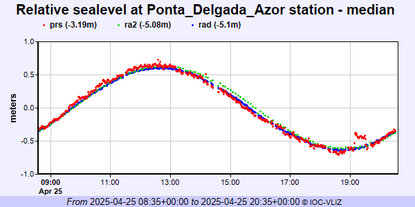 PSMSL Annual Mean Sea Level for '1885' 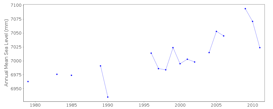 PSMSL Annual Mean Sea Level for '258' 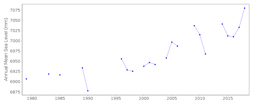 PSMSL Monthly Mean Sea Level for '258' 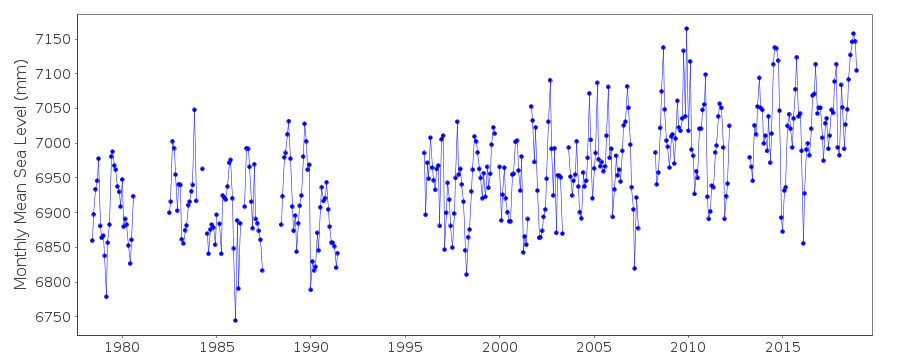
|
|
|