 |
SEALEVEL STATION CATALOG (SSC) |
|
|
|
|
|
| Station catalog metadata [edit] | [station overview] |
|---|
| SSC ID | SSC-pada | | Station Name | Padang | | Country | Indonesia | | Latitude | -0.95 | | Longitude | 100.3667 | | DateLastModified | 2015-10-22 19:02:29 |
| Linked codes |
|---|
| Codes | Location | Latitude | Longitude | Sensors | IOC: pada | Padang | -0.95 | 100.3667 | prs, rad, ra2, ras, bat, sw1, sw2 |
IOC: padn | Padang2 | -0.95 | 100.366667 | prs, rad, ra2, ras, bat, sw1, sw2 |
GLOSS: 45 | Padang (Telu Bayuk) | -1 | 100.36666 | Float |
UHSLC: 107 | Padang | -0.9963 | 100.37565 | N/A |
PTWC: pada | Padang_ID | -0.9500 | 100.3667 | prs, ra2, rad, ras |
PTWC: padn | | | | |
PSMSL: 1686 | PADANG II (TELUK BAYUR) | -0.95 | 100.366667 | N/A |
PSMSL: 2193 | PADANG B | -0.996667 | 100.375 | N/A |
PSMSL: 274 | PADANG I (TELUK BAYUR) | -0.966667 | 100.333333 | N/A |
SONEL_GPS: 2944 | N/A | | | N/A |
SONEL_GPS: 3100 | PADANG | -0.94384400 | 100.36900000 | N/A |
SONEL_TG: 2810 | PADANG | -0.99608000 | 100.37550000 | N/A |
| Distributed metadata source: IOC Sea Level Station Monitoring Facility pada |
|---|
| GTS station code | 301434060404960 |
| GTS message type | SZXX01 |
| Status | Operational |
| Local Contact | Geospacial Agency of Indonesia ( Indonesia ) |
| Other Contact | University of Hawaii Sea Level Center ( USA ) |
| Connection | GTS message |
| Country | Indonesia |
| Sensor 1 | |
| Type of sensor | prs |
| Sampling rate (min) | 1 |
| Sensor 2 | |
| Type of sensor | rad |
| Sampling rate (min) | 1 |
| Sensor 3 | |
| Type of sensor | ra2 |
| Sampling rate (min) | 1 |
| Sensor 4 | |
| Type of sensor | ras |
| Sampling rate (min) | 1 |
| Sensor 5 | |
| Type of sensor | bat |
| Sampling rate (min) | 5 |
| Sensor 6 | |
| Type of sensor | sw1 |
| Sampling rate (min) | 60 |
| Sensor 7 | |
| Type of sensor | sw2 |
| Sampling rate (min) | 60 |
| Distributed metadata source: IOC Sea Level Station Monitoring Facility padn |
|---|
| Status | Down |
| Local Contact | Geospacial Agency of Indonesia ( Indonesia ) |
| Other Contact | University of Hawaii Sea Level Center ( USA ) |
| Connection | BGAN |
| Country | Indonesia |
| Sensor 1 | |
| Type of sensor | prs |
| Sampling rate (min) | 1 |
| Sensor 2 | |
| Type of sensor | rad |
| Sampling rate (min) | 1 |
| Sensor 3 | |
| Type of sensor | ra2 |
| Sampling rate (min) | 1 |
| Sensor 4 | |
| Type of sensor | ras |
| Sampling rate (min) | 1 |
| Sensor 5 | |
| Type of sensor | bat |
| Sampling rate (min) | 5 |
| Sensor 6 | |
| Type of sensor | sw1 |
| Sampling rate (min) | 60 |
| Sensor 7 | |
| Type of sensor | sw2 |
| Sampling rate (min) | 60 |
| Distributed metadata source: GLOSS Station Handbook |
|---|
| Time Zone | 105E, GMT + 7hrs | | Ocean | Indian | | Operational | Yes | | Responsible country | Indonesia | | Data acquisition rate | Digitising interval 15 minutes | | Other relevant information | PSMSL hold data from another gauge (PSMSL ref. 560/031) from 1925-1931. | | Other relevant codes | UHSLC 107 |
| Distributed metadata source: PTWC COMP META file |
| DCP ID | 301434060404960 |
| WMO | SXXX01 |
| Samp Rate | 1 |
| Num# Samp | 5 |
| Unit | M |
| Scale | 1.0000 |
| Xmt Int. | 005 |
| Fst Min. | 0001 |
| HAR | 1 |
| Owner | UHSLC |
| Distributed metadata source: UHSLC |
| UHSLC id | 107 |
| SSC id | pada |
| GLOSS id | 45 |
| UHSLC geojson | https://uhslc.soest.hawaii.edu/data/meta.geojson |
| Research quality data version a | 1986-11-16 - 2004-04-18 |
| Research quality data version b | 2005-12-07 - 2018-12-31 |
| RQ basin | indian |
| Fast delivery | 2005-12-07 - 2026-05-31 |
| Distributed metadata source: PSMSL |
| Name | PADANG II (TELUK BAYUR) |
| GLOSS id | 45 |
| UHSLC ID | 107 |
| SONEL id | 3100 |
| Is RLR | N |
| Has RLR Diagram | N link |
| QC Flag | N |
| Old ID | 560/032 |
| Last Updated | 2006-07-07 |
| Supplier | BAKOSURTANAL |
| Address | BAKOSURTANAL, Jl Raya Jakarta-Bogar Km 46, Cibinong 16911, INDONESIA |
| Metric Start | 1986 |
| Metric End | 1998 |
| Metric Completeness | 50.0 |
| Download metric sea level data. | Use only with extreme caution. |
| Name | PADANG B |
| GLOSS id | 45 |
| UHSLC ID | 107 |
| Is RLR | Y |
| Has RLR Diagram | Y link |
| QC Flag | N |
| Old ID | 560/033 |
| Last Updated | 2020-01-29 |
| Supplier | UNIVERSITY OF HAWAII SEA LEVEL CENTER |
| Address | University of Hawaii Sea Level Center, Department of Oceanography Division of Natural Sciences, 1000 Pope Road, Honolulu, Hawaii 96822, UNITED STATES |
| Metric Start | 2005 |
| Metric End | 2018 |
| Metric Completeness | 90.5 |
| RLR Start | 2005 |
| RLR End | 2018 |
| RLR Completeness | 90.5 |
| Download metric sea level data. | Use only with extreme caution. |
| Name | PADANG I (TELUK BAYUR) |
| GLOSS id | 45 |
| UHSLC ID | 107 |
| Is RLR | N |
| Has RLR Diagram | N link |
| QC Flag | N |
| Old ID | 560/031 |
| Last Updated | null |
| Supplier | INSTITUTE OF HYDRAULIC ENGINEERING |
| Address | Institute of Hydraulic Engineering, Jl. Ir. H. Juanda 193, Bandung 40135, INDONESIA |
| Metric Start | 1925 |
| Metric End | 1931 |
| Metric Completeness | 100.0 |
| Download metric sea level data. | Use only with extreme caution. |
IOC Sea Level Station Monitoring Facility - realtime graph for 'pada' 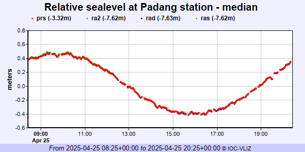 IOC Sea Level Station Monitoring Facility - realtime graph for 'padn'  PSMSL Annual Mean Sea Level for '1686'  PSMSL Annual Mean Sea Level for '2193' 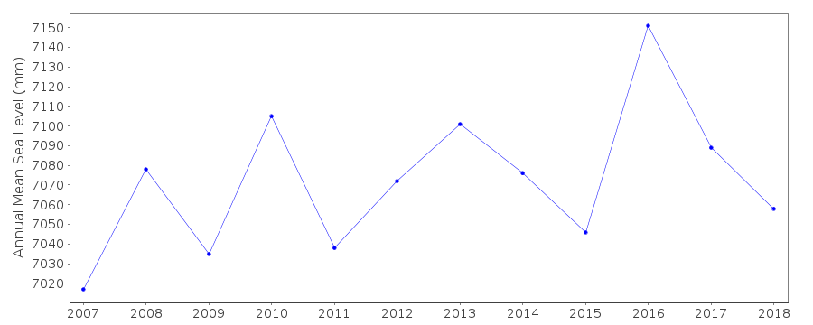 PSMSL Annual Mean Sea Level for '274'  PSMSL Monthly Mean Sea Level for '274' 
|
|
|