 |
SEALEVEL STATION CATALOG (SSC) |
|
|
|
|
|
| Station catalog metadata [edit] | [station overview] |
|---|
| SSC ID | SSC-ofun | | Station Name | Ofunato | | Country | Japan | | Latitude | 39 | | Longitude | 141.75 | | DateLastModified | 2015-10-22 19:02:29 |
| Distributed metadata source: IOC Sea Level Station Monitoring Facility ofun |
|---|
| GTS station code | OFUNATO |
| GTS message type | SWJP40 |
| Status | Operational |
| Local Contact | Japan Meteorological Agency ( Japan ) |
| Connection | GTS message |
| Country | Japan |
| Sensor 1 | |
| Type of sensor | rad |
| Sampling rate (min) | 1 |
| Distributed metadata source: GLOSS Station Handbook |
|---|
| Time Zone | 135E, GMT + 9 hrs | | Ocean | Pacific | | Operational | Yes | | Responsible country | Japan | | Data acquisition rate | Continuous recording | | Tide gauge benchmarks | Japan Met. Agency Benchmark bolt inside tide gauge hut adjacent to stilling well | | Benchmark relationships | Tide Gauge Zero (TGZ) = 1.838m below Tokyo Peil (Mean Sea Level of Tokyo Bay)
TGZ = 5.329m below TGBM (from 1973 onwards)
| | Auxiliary benchmarks | Tide Station BM 1.629m above Tokyo Peil (1997). | | Other relevant information | The TGBM is on top of the stilling well. Another benchmark is near the station which is used to decide the height of the TGBM and monitor the height of the tide station. This second benchmark is levelled in to the nearest first class benchmark which is part of the network operated by the Geographical Survey Institute, Ministry of Construction. Heights of benchmarks are described as above Tokyo Peil (TP). | | Other relevant codes | UHSLC 351 | | Nearest Met. station | Ofunato |
| Distributed metadata source: PTWC COMP META file |
| DCP ID | OFUN |
| WMO | SWJP40 |
| Samp Rate | 1 |
| Num# Samp | 10 |
| Unit | F |
| Scale | 1.0000 |
| Xmt Int. | 010 |
| Fst Min. | 0009 |
| HAR | 1 |
| Owner | JMA |
| Distributed metadata source: UHSLC |
| UHSLC id | 351 |
| SSC id | ofun |
| GLOSS id | 87 |
| UHSLC geojson | https://uhslc.soest.hawaii.edu/data/meta.geojson |
| Research quality data version a | 1963-07-31 - 2023-12-31 |
| RQ basin | pacific |
| Fast delivery | 1963-07-31 - 2026-05-31 |
| Distributed metadata source: PSMSL |
| Name | OFUNATO I |
| GLOSS id | 87 |
| UHSLC ID | 351 |
| SONEL id | 800 |
| Is RLR | Y |
| Has RLR Diagram | Y link |
| QC Flag | N |
| Old ID | 642/021 |
| Last Updated | null |
| Supplier | JAPAN METEOROLOGICAL AGENCY |
| Address | Japan Meteorological Agency, 3-6-9 Toranomon, Minato City, Tokyo, JAPAN |
| Metric Start | 1965 |
| Metric End | 1973 |
| Metric Completeness | 92.6 |
| RLR Start | 1965 |
| RLR End | 1973 |
| RLR Completeness | 92.6 |
| Download metric sea level data. | Use only with extreme caution. |
| Name | OFUNATO II |
| GLOSS id | 87 |
| UHSLC ID | 351 |
| SONEL id | 800 |
| Is RLR | Y |
| Has RLR Diagram | Y link |
| QC Flag | Y |
| Old ID | 642/022 |
| Last Updated | 2026-04-07 |
| Supplier | JAPAN METEOROLOGICAL AGENCY |
| Address | Japan Meteorological Agency, 3-6-9 Toranomon, Minato City, Tokyo, JAPAN |
| Metric Start | 1974 |
| Metric End | 2025 |
| Metric Completeness | 97.8 |
| RLR Start | 1974 |
| RLR End | 2025 |
| RLR Completeness | 97.8 |
| Download metric sea level data. | Use only with extreme caution. |
IOC Sea Level Station Monitoring Facility - realtime graph for 'ofun' 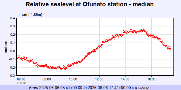 PSMSL Annual Mean Sea Level for '1140' 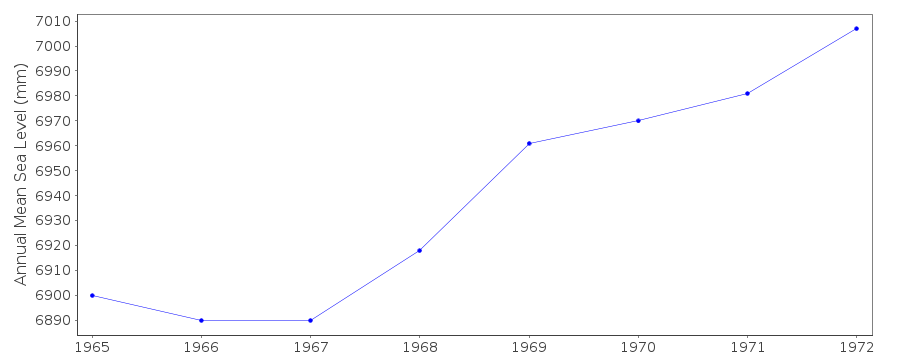 PSMSL Annual Mean Sea Level for '1364' 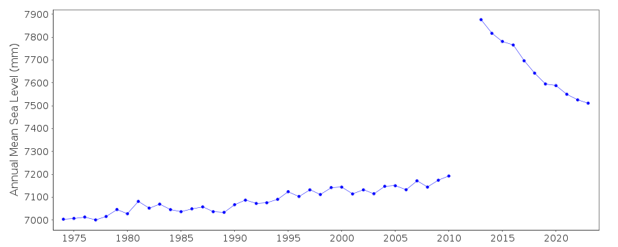 PSMSL Monthly Mean Sea Level for '1364' 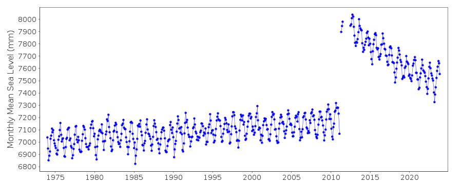
|
|
|