 |
SEALEVEL STATION CATALOG (SSC) |
|
|
|
|
|
| Station catalog metadata [edit] | [station overview] |
|---|
| SSC ID | SSC-oche | | Station Name | Ocheongdo | | Country | South Korea | | Latitude | 36.117222 | | Longitude | 125.984722 | | DateLastModified | 2015-10-22 19:02:29 |
| Linked codes |
|---|
| Codes | Location | Latitude | Longitude | Sensors | PSMSL: 2046 | EOCHEONGDO | 36.117222 | 125.984722 | N/A |
| Distributed metadata source: PSMSL |
| Name | EOCHEONGDO |
| Is RLR | Y |
| Has RLR Diagram | Y link |
| QC Flag | N |
| Old ID | 620/018 |
| Last Updated | 2026-04-10 |
| Supplier | KOREA HYDROGRAPHIC AND OCEANOGRAPHIC AGENCY (KHOA) |
| Address | Korea Hydrographic and Oceanographic Agency (KHOA), 351, Haeyang-ro, Yeongdo-gu, Busan, Republic of Korea, KOREA, REPUBLIC OF |
| Metric Start | 2008 |
| Metric End | 2024 |
| Metric Completeness | 100.0 |
| RLR Start | 2008 |
| RLR End | 2024 |
| RLR Completeness | 100.0 |
| Download metric sea level data. | Use only with extreme caution. |
PSMSL Annual Mean Sea Level for '2046' 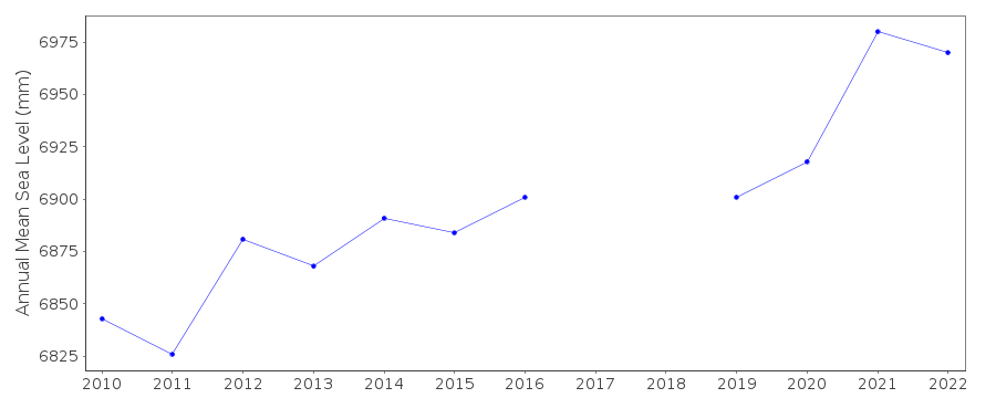 PSMSL Monthly Mean Sea Level for '2046' 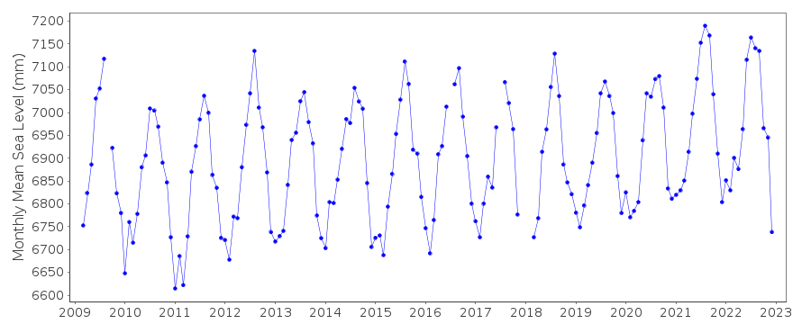
|
|
|