 |
SEALEVEL STATION CATALOG (SSC) |
|
|
|
|
|
| Station catalog metadata [edit] | [station overview] |
|---|
| SSC ID | SSC-nyal | | Station Name | Ny Ålesund | | Country | Norway | | Latitude | 78.933333 | | Longitude | 11.95 | | DateLastModified | 2015-10-22 19:02:29 |
| Distributed metadata source: IOC Sea Level Station Monitoring Facility nyal |
|---|
| Status | Operational |
| Local Contact | Norwegian Hydrographic Service ( Norway ) |
| Connection | WEB service |
| Country | Norway |
| Sensor 1 | |
| Type of sensor | flt |
| Sampling rate (min) | 10 |
| Distributed metadata source: GLOSS Station Handbook |
|---|
| Time Zone | GMT+ 2 hrs | | Data acquisition rate | Sampling rate 30 sec | | Auxiliary benchmarks | RLR (1994) is 20.5m below TGBM Fundamentalpunkt for Svalbard
Add 5.00m to data to refer to RLR 1994 | | Other relevant information | CGPS since 1993. GPS receiver is installed near the VLBI-station ( Very long baseline Interferometry) which is located 1.5km from tide gauge.
GPS receiver type Serial num. Firmware version Antenna type Radome
CGPS from 1993: AOABenchmark ACT 2020 3.3.32.2 AOAD/M_B Dome
CGPS from 1997: AOA Benchmark ACT 2023 3.3.32.2 ASH 701073.3 Snow |
| Distributed metadata source: UHSLC |
| UHSLC id | 823 |
| SSC id | nyal |
| GLOSS id | 345 |
| UHSLC geojson | https://uhslc.soest.hawaii.edu/data/meta.geojson |
| Research quality data version a | 1976-08-30 - 2018-12-30 |
| RQ basin | atlantic |
| Fast delivery | 1976-08-30 - 2026-05-31 |
| Distributed metadata source: PSMSL |
| Name | NY-ALESUND |
| GLOSS id | 345 |
| UHSLC ID | 823 |
| SONEL id | 4471 |
| Is RLR | Y |
| Has RLR Diagram | Y link |
| QC Flag | N |
| Old ID | 025/021 |
| Last Updated | 2026-01-30 |
| Supplier | NORWEGIAN MAPPING AUTHORITY |
| Address | Norwegian Mapping Authority, Hydrographic Service , Po. Box 60, 4001 Stavanger, NORWAY |
| Metric Start | 1976 |
| Metric End | 2025 |
| Metric Completeness | 95.0 |
| RLR Start | 1976 |
| RLR End | 2025 |
| RLR Completeness | 89.2 |
| Download metric sea level data. | Use only with extreme caution. |
IOC Sea Level Station Monitoring Facility - realtime graph for 'nyal' 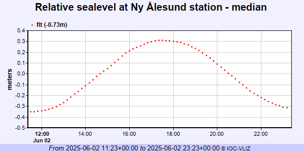 PSMSL Annual Mean Sea Level for '1421' 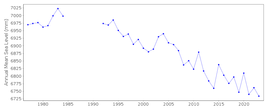 PSMSL Monthly Mean Sea Level for '1421' 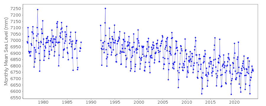
|
|
|