 |
SEALEVEL STATION CATALOG (SSC) |
|
|
|
|
|
| Station catalog metadata [edit] | [station overview] |
|---|
| SSC ID | SSC-nshi | | Station Name | North Shields | | Country | United Kingdom | | Latitude | 55.01 | | Longitude | -1.44 | | DateLastModified | 2015-10-22 19:02:29 |
| Distributed metadata source: IOC Sea Level Station Monitoring Facility nshi |
|---|
| Status | Operational |
| Local Contact | National Oceanography Centre ( UK ) |
| Connection | FTP box |
| Country | UK |
| Sensor 1 | |
| Type of sensor | bub |
| Sampling rate (min) | 15 |
| Distributed metadata source: PSMSL |
| Name | TYNEMOUTH |
| Is RLR | N |
| Has RLR Diagram | N link |
| QC Flag | N |
| Old ID | 170/051 |
| Last Updated | null |
| Supplier | N.O.C. |
| Address | British Oceanographic Data Centre, National Oceanography Centre, Joseph Proudman Building, 6 Brownlow Street, Liverpool, L3 5DA, UNITED KINGDOM |
| Metric Start | 1947 |
| Metric End | 1956 |
| Metric Completeness | 40.0 |
| Download metric sea level data. | Use only with extreme caution. |
| Name | NORTH SHIELDS |
| SONEL id | 2427 |
| Is RLR | Y |
| Has RLR Diagram | Y link |
| QC Flag | N |
| Old ID | 170/053 |
| Last Updated | 2025-02-19 |
| Supplier | ENVIRONMENT AGENCY |
| Address | Environment Agency, Horizon House, Deanery Road, BS1 5AH, Bristol, UNITED KINGDOM |
| Metric Start | 1895 |
| Metric End | 2024 |
| Metric Completeness | 91.3 |
| RLR Start | 1895 |
| RLR End | 2024 |
| RLR Completeness | 91.3 |
| Download metric sea level data. | Use only with extreme caution. |
IOC Sea Level Station Monitoring Facility - realtime graph for 'nshi' 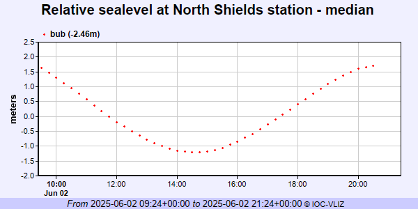 PSMSL Annual Mean Sea Level for '533'  PSMSL Annual Mean Sea Level for '95' 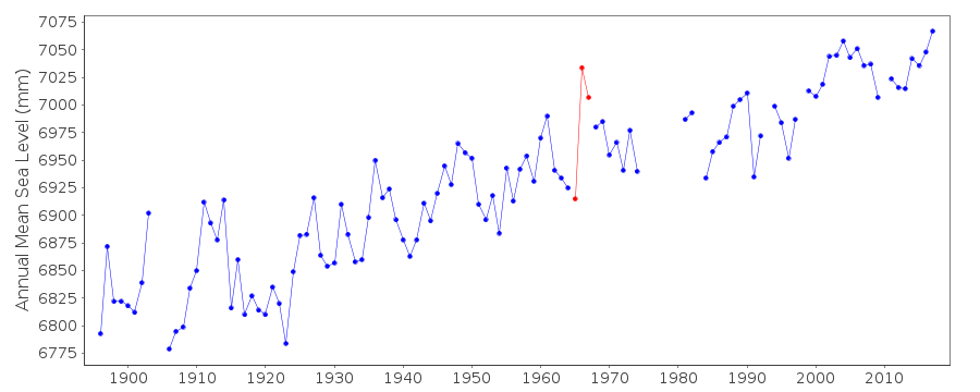 PSMSL Monthly Mean Sea Level for '95' 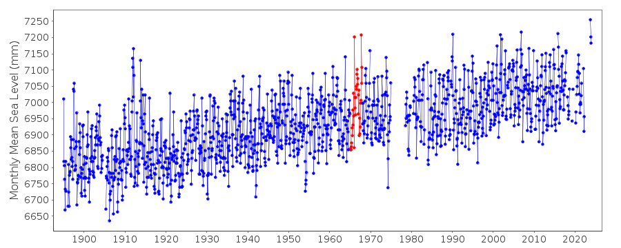
|
|
|