 |
SEALEVEL STATION CATALOG (SSC) |
|
|
|
|
|
| Station catalog metadata [edit] | [station overview] |
|---|
| SSC ID | SSC-nosy | | Station Name | Nosy-Be | | Country | Madagascar | | Latitude | -13.4 | | Longitude | 48.28333 | | DateLastModified | 2015-10-22 19:02:29 |
| Distributed metadata source: GLOSS Station Handbook |
|---|
| Time Zone | 045E, GMT + 3hrs | | Ocean | Indian | | Operational | Yes | | Responsible country | Madagascar | | Additional parameters | Temperature and salinity | | Tide gauge benchmarks | Tide gauge benchmark is situated on a flush bracket in the front of the tide gauge on the quay. | | Benchmark relationships | Tide gauge zero (TGZ) = zero hydrographic
TGZ = 4.72m below TGBM
TGBM = 3.02m below disc SH: material reference set on the entrance of the wharf (from 1987 onwards)
| | Auxiliary benchmarks | Disc SH set on the entrance of the CNRO wharf 7.74m above zero hydrographic | | Other relevant information | PSMSL hold data from another gauge at Nosy-Be (PSMSL Code 440/001 1958- 1968, 1970-1972). | | Other relevant codes | UHSLC 150 | | Nearest Met. station | Fascene Airport Nosy-Be |
| Distributed metadata source: UHSLC |
| UHSLC id | 150 |
| SSC id | nosy |
| GLOSS id | 15 |
| UHSLC geojson | https://uhslc.soest.hawaii.edu/data/meta.geojson |
| Research quality data version a | 1958-01-01 - 2014-10-05 |
| RQ basin | indian |
| Distributed metadata source: PSMSL |
| Name | NOSY-BE II |
| GLOSS id | 15 |
| UHSLC ID | 150 |
| SONEL id | 4363 |
| Is RLR | N |
| Has RLR Diagram | N link |
| QC Flag | N |
| Old ID | 440/002 |
| Last Updated | 2012-01-16 |
| Supplier | C.N.R.O., MADAGASCAR |
| Address | Centre National de Recherches Oceanographique, B.P. 68, 207 Nosy-be, MADAGASCAR |
| Metric Start | 1987 |
| Metric End | 1999 |
| Metric Completeness | 54.5 |
| Download metric sea level data. | Use only with extreme caution. |
| Name | NOSY-BE |
| GLOSS id | 15 |
| UHSLC ID | 150 |
| Is RLR | Y |
| Has RLR Diagram | Y link |
| QC Flag | N |
| Old ID | 440/001 |
| Last Updated | null |
| Supplier | SERVICE HYD. ET OCEAN. DE LA MARINE |
| Address | SHOM, 13 rue de Chatelier, 29200 BREST , FRANCE |
| Metric Start | 1958 |
| Metric End | 1972 |
| Metric Completeness | 72.2 |
| RLR Start | 1958 |
| RLR End | 1972 |
| RLR Completeness | 72.2 |
| Download metric sea level data. | Use only with extreme caution. |
PSMSL Annual Mean Sea Level for '1712'  PSMSL Annual Mean Sea Level for '926' 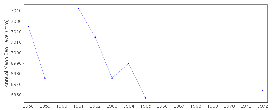 PSMSL Monthly Mean Sea Level for '926' 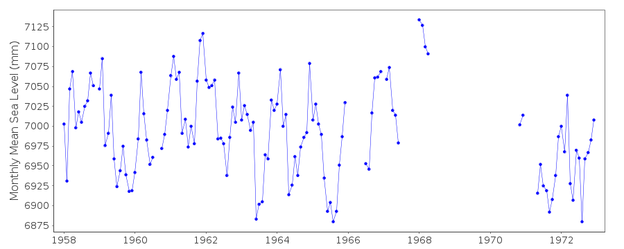
|
|
|