 |
SEALEVEL STATION CATALOG (SSC) |
|
|
|
|
|
| Station catalog metadata [edit] | [station overview] |
|---|
| SSC ID | SSC-norf | | Station Name | Norfolk Island | | Country | Australia | | Latitude | -29.06666 | | Longitude | 167.95 | | DateLastModified | 2015-10-22 19:02:29 |
| Linked codes |
|---|
| Codes | Location | Latitude | Longitude | Sensors | IOC: kjni | Kingston_Jetty_Norfolk_Is | -29.0591 | 167.9536 | rad |
GLOSS: 124 | Norfolk Is. | -29.06666 | 167.95 | Float |
UHSLC: 62 | Norfolk Island | -29.0667 | 167.9333 | N/A |
PSMSL: 1129 | NORFOLK ISLAND II | -29.066667 | 167.933333 | N/A |
PSMSL: 821 | NORFOLK ISLAND | -29.058333 | 167.953611 | N/A |
SONEL_GPS: 2925 | NORFOLK ISLAND | -29.04335190 | 167.93882980 | N/A |
SONEL_TG: 2843 | NORFOLK ISLAND | -29.05833500 | 167.95356600 | N/A |
| Distributed metadata source: IOC Sea Level Station Monitoring Facility kjni |
|---|
| GTS station code | 57700 |
| GTS message type | SZPA01 |
| Status | Operational |
| Local Contact | National Tidal Centre/Australian Bureau of Meteorology ( Australia ) |
| Connection | GTS message |
| Country | Norfolk Island |
| Sensor 1 | |
| Type of sensor | rad |
| Sampling rate (min) | 1 |
| Distributed metadata source: GLOSS Station Handbook |
|---|
| Ocean | Pacific | | Operational | Yes | | Responsible country | Australia | | Data acquisition rate | 15 minute samples | | Tide gauge benchmarks | BM 1: the top of a concrete block protruding about 0.3m above ground level and marked ZNI. It is surrounded by a rectangular concrete collar which shows latitude, longitude & height in feet above MSL. | | Benchmark relationships | Tide Gauge Zero (TGZ) = 5.432m below BM 1 (1965 onwards) | | Auxiliary benchmarks | BMR 8290 3092
NMV/C/443: small piece of blue metal gravel embedded in and protruding slightly above the concrete top of the sea wall.
NMV/C/444 & NMV/C/445: centres of triangles carved in flat concrete on the top of the sea wall of the jetty, with their numbers next to them.
TRIG 'M': drill hole in a damaged concrete block.
| | Other relevant information | Float/stilling well analogue gauge 1965-1985.
Geocentric measurement: Precise ephemeris, single point doppler fix ('M') in 1977.
PSMSL also hold data from another gauge at Norfolk Island (PSMSL Code 680/092 1965-1966, 1969-1987).
| | Other relevant codes | NTF port no. 57700, UHSLC 062 | | Nearest Met. station | Norfolk Island Airport |
| Distributed metadata source: UHSLC |
| UHSLC id | 062 |
| SSC id | norf |
| GLOSS id | 124 |
| UHSLC geojson | https://uhslc.soest.hawaii.edu/data/meta.geojson |
| Research quality data version a | 1985-11-13 - 1987-12-31 |
| Research quality data version b | 1994-02-01 - 1999-12-31 |
| RQ basin | pacific |
| Distributed metadata source: PSMSL |
| Name | NORFOLK ISLAND II |
| GLOSS id | 124 |
| UHSLC ID | 62 |
| Is RLR | N |
| Has RLR Diagram | N link |
| QC Flag | N |
| Old ID | 680/092 |
| Last Updated | 1993-05-24 |
| Supplier | NATIONAL TIDAL FACILITY |
| Address | National Tidal Facility, G.P.O. Box 2100, S.A. 5001, Adelaide , AUSTRALIA |
| Metric Start | 1965 |
| Metric End | 1987 |
| Metric Completeness | 60.1 |
| Download metric sea level data. | Use only with extreme caution. |
| Name | NORFOLK ISLAND |
| GLOSS id | 124 |
| UHSLC ID | 62 |
| SONEL id | 2925 |
| Is RLR | Y |
| Has RLR Diagram | Y link |
| QC Flag | N |
| Old ID | 680/091 |
| Last Updated | 2016-09-28 |
| Supplier | NATIONAL TIDAL CENTRE |
| Address | National Tidal Centre, Bureau of Meteorology, PO Box 421, Kent Town 5071, South Australia, AUSTRALIA |
| Metric Start | 1957 |
| Metric End | 2015 |
| Metric Completeness | 47.0 |
| RLR Start | 1994 |
| RLR End | 2015 |
| RLR Completeness | 92.0 |
| Download metric sea level data. | Use only with extreme caution. |
IOC Sea Level Station Monitoring Facility - realtime graph for 'kjni'  PSMSL Annual Mean Sea Level for '1129'  PSMSL Annual Mean Sea Level for '821' 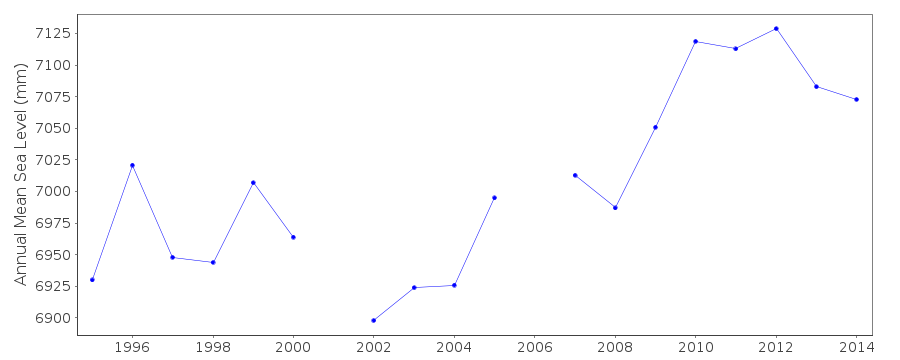 PSMSL Monthly Mean Sea Level for '821' 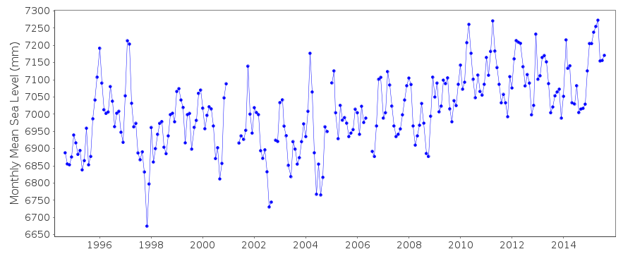
|
|
|