 |
SEALEVEL STATION CATALOG (SSC) |
|
|
|
|
|
| Station catalog metadata [edit] | [station overview] |
|---|
| SSC ID | SSC-newl | | Station Name | Newlyn | | Country | United Kingdom | | Latitude | 50.103 | | Longitude | -5.54275 | | DateLastModified | 2015-10-22 19:02:29 |
| Distributed metadata source: IOC Sea Level Station Monitoring Facility newl |
|---|
| Status | Down |
| Local Contact | National Oceanography Centre ( UK ) |
| Connection | FTP box |
| Country | UK |
| Sensor 1 | |
| Type of sensor | flt |
| Sampling rate (min) | 0.1667 |
| Sensor 2 | |
| Type of sensor | bub |
| Sampling rate (min) | 0.1667 |
| Distributed metadata source: IOC Sea Level Station Monitoring Facility newl2 |
|---|
| Status | Operational |
| Local Contact | National Oceanography Centre ( UK ) |
| Connection | FTP box |
| Country | UK |
| Sensor 1 | |
| Type of sensor | bub |
| Sampling rate (min) | 15 |
| Distributed metadata source: IOC Sea Level Station Monitoring Facility newl3 |
|---|
| Status | Operational |
| Local Contact | National Oceanography Centre ( UK ) |
| Connection | FTP box |
| Country | UK |
| Sensor 1 | |
| Type of sensor | rad |
| Sampling rate (min) | 1 |
| Sensor 2 | |
| Type of sensor | ra2 |
| Sampling rate (min) | 1 |
| Sensor 3 | |
| Type of sensor | atm |
| Sampling rate (min) | 15 |
| Distributed metadata source: GLOSS Station Handbook |
|---|
| Time Zone | 000E, GMT | | Ocean | Atlantic | | Operational | Yes | | Additional parameters | Sea temperature | | Tide gauge benchmarks | Ordnance Survey Benchmark bolt inside tide gauge hut, adjacent to stilling well. Ordnance Survey grid reference: SW 4677 2856. | | Benchmark relationships | TGZ = Admiralty Chart Datum (ACD)
TGZ = 3.05m below Ordnance Datum Newlyn (ODN)
TGZ = 7.8012m below TGBM (from 1988 onwards)
| | Auxiliary benchmarks | AUX 1: Flush bracket 1565 on NW face of South Pier wall 17.8m SW of tidal observatory. OS grid reference: SW 4673 2851
AUX 2: Flush bracket 1520 on NW face of wall on SE side of South Pier Road. OS grid reference: SW 4659 2841
| | Other relevant codes | UHSLC 294 | | Nearest Met. station | St. Mawgan |
| Distributed metadata source: UHSLC |
| UHSLC id | 294 |
| SSC id | newl |
| GLOSS id | 241 |
| UHSLC geojson | https://uhslc.soest.hawaii.edu/data/meta.geojson |
| Research quality data version a | 1915-04-22 - 2016-12-31 |
| RQ basin | atlantic |
| Fast delivery | 1915-04-22 - 2016-12-31 |
| Distributed metadata source: PSMSL |
| Name | NEWLYN |
| GLOSS id | 241 |
| UHSLC ID | 294 |
| SONEL id | 753 |
| Is RLR | Y |
| Has RLR Diagram | Y link |
| QC Flag | N |
| Old ID | 170/161 |
| Last Updated | 2026-02-19 |
| Supplier | ENVIRONMENT AGENCY |
| Address | Environment Agency, Horizon House, Deanery Road, BS1 5AH, Bristol, UNITED KINGDOM |
| Metric Start | 1915 |
| Metric End | 2025 |
| Metric Completeness | 97.4 |
| RLR Start | 1915 |
| RLR End | 2025 |
| RLR Completeness | 97.4 |
| Download metric sea level data. | Use only with extreme caution. |
IOC Sea Level Station Monitoring Facility - realtime graph for 'newl'  IOC Sea Level Station Monitoring Facility - realtime graph for 'newl2' 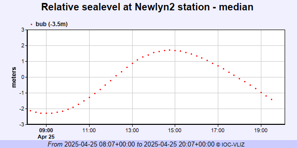 IOC Sea Level Station Monitoring Facility - realtime graph for 'newl3' 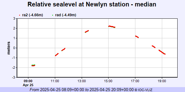 PSMSL Annual Mean Sea Level for '202' 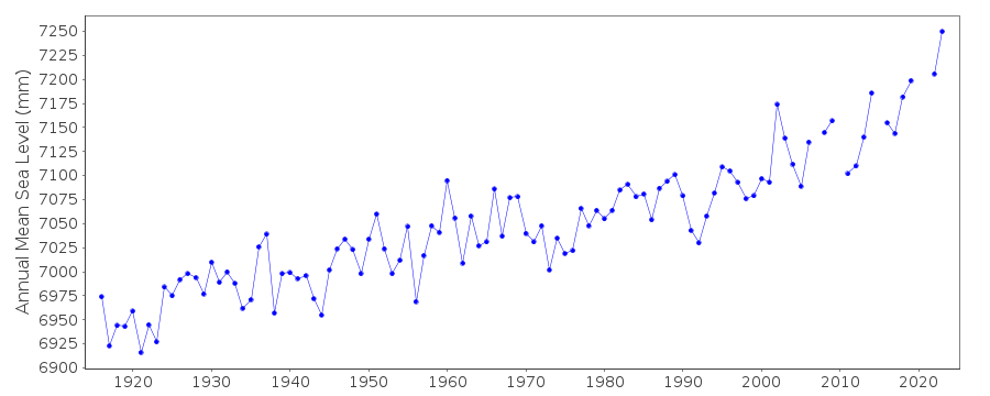 PSMSL Monthly Mean Sea Level for '202' 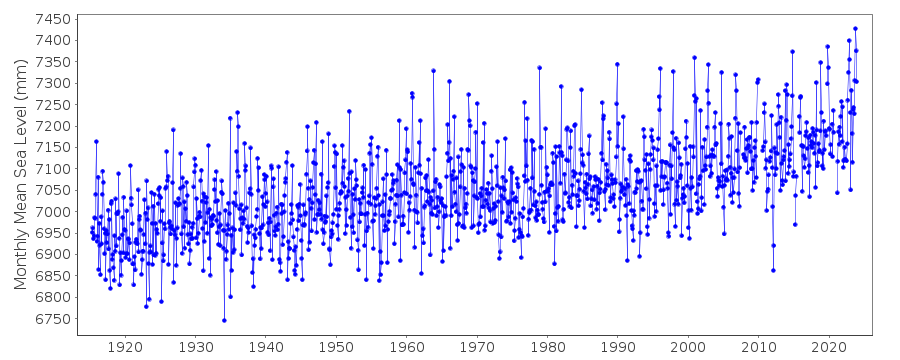
|
|
|