 |
SEALEVEL STATION CATALOG (SSC) |
|
|
|
|
|
| Station catalog metadata [edit] | [station overview] |
|---|
| SSC ID | SSC-napt | | Station Name | Port Napier | | Country | New Zealand | | Latitude | -39.4756612 | | Longitude | 176.920066 | | DateLastModified | 2015-10-22 19:02:29 |
| Linked codes |
|---|
| Codes | Location | Latitude | Longitude | Sensors | IOC: napt | Port Napier | -39.4756612 | 176.920066 | prs |
UHSLC: 668 | Napier | -39.4833 | 176.9167 | N/A |
PTWC: napt | Port_Napier_NZ | -39.4757 | 176.9201 | prs |
PSMSL: 1750 | NAPIER | -39.4755 | 176.91998 | N/A |
| Distributed metadata source: IOC Sea Level Station Monitoring Facility napt |
|---|
| GTS station code | NAPT |
| GTS message type | SZNZ01 |
| Status | Operational |
| Local Contact | Land Information New Zealand ( New Zealand ) |
| Connection | GTS message |
| Country | New Zealand |
| Sensor 1 | |
| Type of sensor | prs |
| Sampling rate (min) | 1 |
| Distributed metadata source: PTWC COMP META file |
| DCP ID | NAPT |
| WMO | SZNZ01 |
| Samp Rate | 1 |
| Num# Samp | 6 |
| Unit | M |
| Scale | 1.0000 |
| Xmt Int. | 003 |
| Fst Min. | 0000 |
| HAR | 1 |
| Owner | GNS |
| Distributed metadata source: UHSLC |
| UHSLC id | 668 |
| SSC id | napt |
| UHSLC geojson | https://uhslc.soest.hawaii.edu/data/meta.geojson |
| Research quality data version a | 1989-01-01 - 2024-12-31 |
| RQ basin | pacific |
| Distributed metadata source: PSMSL |
| Name | NAPIER |
| UHSLC ID | 668 |
| Is RLR | Y |
| Has RLR Diagram | Y link |
| QC Flag | N |
| Old ID | 690/009 |
| Last Updated | 2026-02-17 |
| Supplier | LAND INFORMATION NEW ZEALAND (LINZ) |
| Address | Land Information New Zealand , 155 The Terrace, PO 5501, Wellington 6145, NEW ZEALAND |
| Metric Start | 1989 |
| Metric End | 2025 |
| Metric Completeness | 85.8 |
| RLR Start | 1989 |
| RLR End | 2025 |
| RLR Completeness | 85.8 |
| Download metric sea level data. | Use only with extreme caution. |
IOC Sea Level Station Monitoring Facility - realtime graph for 'napt' 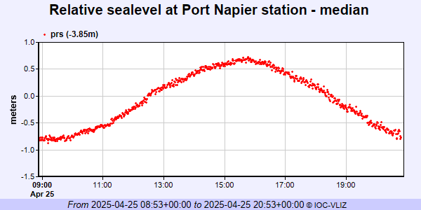 PSMSL Annual Mean Sea Level for '1750' 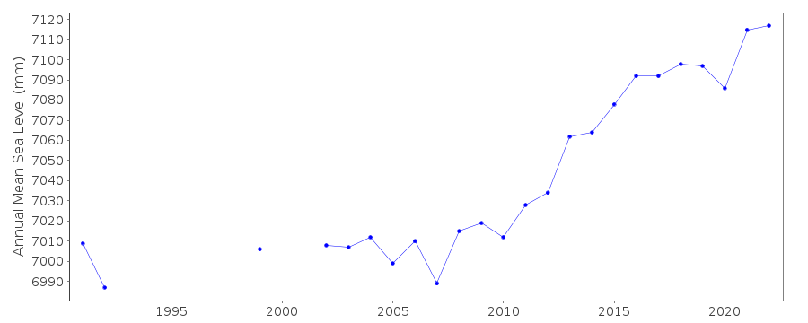 PSMSL Monthly Mean Sea Level for '1750' 
|
|
|