 |
SEALEVEL STATION CATALOG (SSC) |
|
|
|
|
|
| Station catalog metadata [edit] | [station overview] |
|---|
| SSC ID | SSC-moul | | Station Name | Moulmein | | Country | Myanmar | | Latitude | 16.4833 | | Longitude | 97.6166 | | DateLastModified | 2015-10-22 19:02:29 |
| Linked codes |
|---|
| Codes | Location | Latitude | Longitude | Sensors | IOC: moul | Moulmein | 16.4833 | 97.6166 | prs, rad, enc, bat, sw1, sw2 |
GLOSS: 141 | Moulmein (Mawlamyine) | 16.48333 | 97.61666 | |
UHSLC: 906 | Moulmein | 16.46557 | 97.62193 | N/A |
PTWC: moul | Moulmein_MM | 16.4654 | 97.6219 | prs, rad, enc |
PSMSL: 2266 | MOULMEIN II | 16.465 | 97.621667 | N/A |
PSMSL: 747 | MOULMEIN | 16.483333 | 97.616667 | N/A |
SONEL_TG: 2845 | MOULMEIN | 16.48330000 | 97.61660000 | N/A |
| Distributed metadata source: IOC Sea Level Station Monitoring Facility moul |
|---|
| GTS station code | 0650AFA4 |
| GTS message type | SZBM40 |
| Status | Down |
| Local Contact | Department of Meteorology and Hydrology ( Myanmar ) |
| Other Contact | University of Hawaii Sea Level Center ( USA ) |
| Connection | GTS message |
| Country | Myanmar |
| Sensor 1 | |
| Type of sensor | prs |
| Sampling rate (min) | 1 |
| Sensor 2 | |
| Type of sensor | rad |
| Sampling rate (min) | 1 |
| Sensor 3 | |
| Type of sensor | enc |
| Sampling rate (min) | 6 |
| Sensor 4 | |
| Type of sensor | sw1 |
| Sampling rate (min) | 60 |
| Sensor 5 | |
| Type of sensor | sw2 |
| Sampling rate (min) | 60 |
| Sensor 6 | |
| Type of sensor | bat |
| Sampling rate (min) | 6 |
| Distributed metadata source: GLOSS Station Handbook |
|---|
| Ocean | Indian | | Operational | No | | Responsible country | Myanmar | | Tide gauge benchmarks | Benchmark in the verandah of the Telegraph Office | | Benchmark relationships | Admiralty Chart Datum (ACD) is 7.3m below Port Survey Datum (PSD) from 1965 onwards |
| Distributed metadata source: PTWC COMP META file |
| DCP ID | 0650AFA4 |
| WMO | SZBM40 |
| Samp Rate | 6 |
| Num# Samp | 3 |
| Unit | M |
| Scale | 1.0000 |
| Xmt Int. | 006 |
| Fst Min. | 0000 |
| HAR | 0 |
| Owner | UHSLC |
| Distributed metadata source: UHSLC |
| UHSLC id | 906 |
| SSC id | moul |
| GLOSS id | 141 |
| UHSLC geojson | https://uhslc.soest.hawaii.edu/data/meta.geojson |
| Research quality data version a | 2006-12-01 - 2020-06-13 |
| RQ basin | indian |
| Fast delivery | 2006-12-01 - 2023-06-14 |
| Distributed metadata source: PSMSL |
| Name | MOULMEIN II |
| GLOSS id | 141 |
| UHSLC ID | 906 |
| Is RLR | Y |
| Has RLR Diagram | Y link |
| QC Flag | Y |
| Old ID | 530/022 |
| Last Updated | 2023-03-07 |
| Supplier | UNIVERSITY OF HAWAII SEA LEVEL CENTER |
| Address | University of Hawaii Sea Level Center, Department of Oceanography Division of Natural Sciences, 1000 Pope Road, Honolulu, Hawaii 96822, UNITED STATES |
| Metric Start | 2006 |
| Metric End | 2018 |
| Metric Completeness | 76.9 |
| RLR Start | 2006 |
| RLR End | 2018 |
| RLR Completeness | 76.9 |
| Download metric sea level data. | Use only with extreme caution. |
| Name | MOULMEIN |
| GLOSS id | 141 |
| UHSLC ID | 906 |
| Is RLR | Y |
| Has RLR Diagram | Y link |
| QC Flag | N |
| Old ID | 530/021 |
| Last Updated | null |
| Supplier | SURVEY OF INDIA |
| Address | Survey of India, Geodetic and Research Branch, 17 E.C. Road, Dehra Dun , PIN 248 001, INDIA |
| Metric Start | 1954 |
| Metric End | 1964 |
| Metric Completeness | 97.7 |
| RLR Start | 1954 |
| RLR End | 1964 |
| RLR Completeness | 97.7 |
| Download metric sea level data. | Use only with extreme caution. |
IOC Sea Level Station Monitoring Facility - realtime graph for 'moul'  PSMSL Annual Mean Sea Level for '2266' 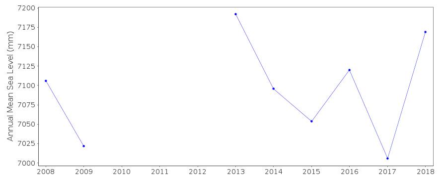 PSMSL Annual Mean Sea Level for '747' 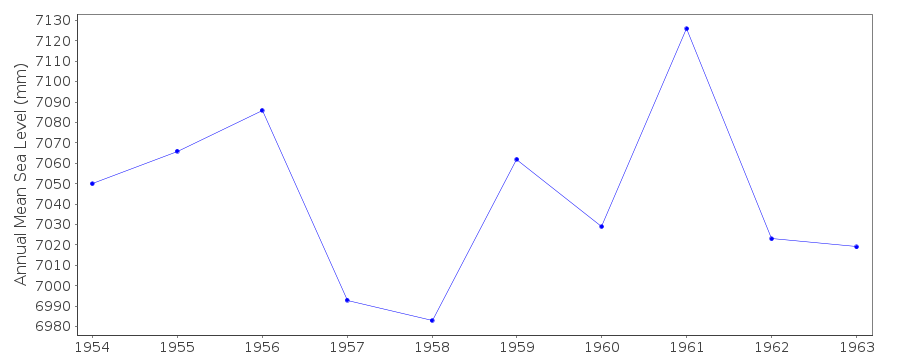 PSMSL Monthly Mean Sea Level for '747' 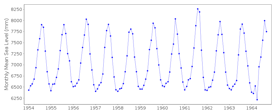
|
|
|