 |
SEALEVEL STATION CATALOG (SSC) |
|
|
|
|
|
| Station catalog metadata [edit] | [station overview] |
|---|
| SSC ID | SSC-momb | | Station Name | Mombasa | | Country | Kenya | | Latitude | -4.067 | | Longitude | 39.65 | | DateLastModified | 2015-10-22 19:02:29 |
| Linked codes |
|---|
| Codes | Location | Latitude | Longitude | Sensors | IOC: momb | Mombasa | -4.069663 | 39.657247 | prs, rad, ra2, bat, sw1, sw2 |
GLOSS: 8 | Mombasa | -4.05 | 39.66666 | Float, Pressure, Radar |
UHSLC: 101 | Mombasa | -4.06999 | 39.65732 | N/A |
PTWC: momb | Mombasa_KE | -4.0701 | 39.6573 | prs, rad, ra2 |
PSMSL: 2183 | MOMBASA II | -4.066667 | 39.65 | N/A |
PSMSL: 370 | MOMBASA | -4.066667 | 39.65 | N/A |
SONEL_TG: 2794 | MOMBASA | -4.06700000 | 39.65000000 | N/A |
SONEL_TG: 3583 | MOMBASA | -4.06666700 | 39.65000000 | N/A |
| Distributed metadata source: IOC Sea Level Station Monitoring Facility momb |
|---|
| GTS station code | 22ADF72A |
| GTS message type | SXXX33 |
| Status | Operational |
| Local Contact | Kenya Marine and Fisheries Research Institute ( Kenya ) |
| Other Contact | University of Hawaii Sea Level Center ( USA ) |
| Connection | GTS message |
| Country | Kenya |
| Sensor 1 | |
| Type of sensor | prs |
| Sampling rate (min) | 1 |
| Sensor 2 | |
| Type of sensor | rad |
| Sampling rate (min) | 3 |
| Sensor 3 | |
| Type of sensor | ra2 |
| Sampling rate (min) | 5 |
| Sensor 4 | |
| Type of sensor | sw1 |
| Sampling rate (min) | 60 |
| Sensor 5 | |
| Type of sensor | sw2 |
| Sampling rate (min) | 60 |
| Sensor 6 | |
| Type of sensor | bat |
| Sampling rate (min) | 15 |
| Distributed metadata source: GLOSS Station Handbook |
|---|
| Time Zone | 045E, GMT + 3hrs | | Ocean | Indian | | Operational | Yes | | Responsible country | Kenya | | Data acquisition rate | Hourly intervals | | Tide gauge benchmarks | BM@ is a bolt fixed on the tide staff at 3.8m above tide staff zero. | | Benchmark relationships | Tide gauge zero (TGZ) = Admiralty Chart Datum - 0.942m
TGZ = East African Railways Datum - 0.912m
TGZ = Survey of Kenya Datum - 2.790m (from 1989)
TGZ = 3.800m below BM@
| | Auxiliary benchmarks | BM1 (TGZ is 5.683m below BM1 - June 1989)
BM2 (TGZ is 5.850m below BM2 - June 1989)
BM3 (TGZ is 13.883m below BM3 - April 1987)
BM N-3 (TGZ is 6.226m below TGZ - June 1989)
| | Other relevant information | Munro gauge was located at different place in the same port until 1976. Valeport pneumatic gauge situated 350km to the north of Lamu since December 1988. | | Other relevant codes | UHSLC 101 | | Nearest Met. station | Mombasa International Airport |
| Distributed metadata source: PTWC COMP META file |
| DCP ID | 22ADF72A |
| WMO | SXXX33 |
| Samp Rate | 5 |
| Num# Samp | 6 |
| Unit | M |
| Scale | 1.0000 |
| Xmt Int. | 015 |
| Fst Min. | 0006 |
| HAR | 1 |
| Owner | UHSLC |
| Distributed metadata source: UHSLC |
| UHSLC id | 101 |
| SSC id | momb |
| GLOSS id | 8 |
| UHSLC geojson | https://uhslc.soest.hawaii.edu/data/meta.geojson |
| Research quality data version a | 1986-06-17 - 2024-12-31 |
| RQ basin | indian |
| Fast delivery | 1986-06-17 - 2026-05-31 |
| Distributed metadata source: PSMSL |
| Name | MOMBASA II |
| GLOSS id | 8 |
| UHSLC ID | 101 |
| Is RLR | Y |
| Has RLR Diagram | Y link |
| QC Flag | N |
| Old ID | 470/002 |
| Last Updated | 2020-01-29 |
| Supplier | UNIVERSITY OF HAWAII SEA LEVEL CENTER |
| Address | University of Hawaii Sea Level Center, Department of Oceanography Division of Natural Sciences, 1000 Pope Road, Honolulu, Hawaii 96822, UNITED STATES |
| Metric Start | 1986 |
| Metric End | 2018 |
| Metric Completeness | 75.5 |
| RLR Start | 1986 |
| RLR End | 2018 |
| RLR Completeness | 75.5 |
| Download metric sea level data. | Use only with extreme caution. |
| Name | MOMBASA |
| GLOSS id | 8 |
| UHSLC ID | 101 |
| Is RLR | N |
| Has RLR Diagram | N link |
| QC Flag | N |
| Old ID | 470/001 |
| Last Updated | null |
| Supplier | KENYA MARINE AND FISHERIES RESEARCH LAB. |
| Address | Kenya Marine and Fisheries Research Institute, Mombasa Laboratory, P.O. Box 81651-80100, Mombasa, KENYA |
| Metric Start | 1932 |
| Metric End | 1975 |
| Metric Completeness | 10.0 |
| Download metric sea level data. | Use only with extreme caution. |
IOC Sea Level Station Monitoring Facility - realtime graph for 'momb' 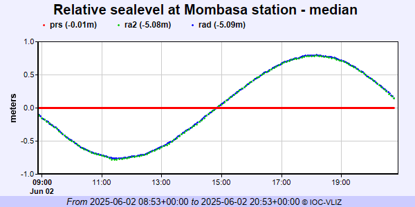 PSMSL Annual Mean Sea Level for '2183' 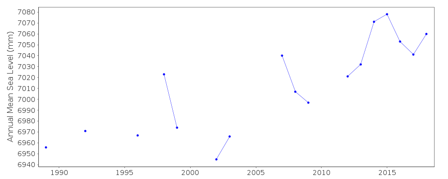 PSMSL Annual Mean Sea Level for '370'  PSMSL Monthly Mean Sea Level for '370' 
|
|
|